From A(storia) to B(rookings) Down the Oregon Coast

As another summer comes to a close, I am enjoying looking back at some photos from the past few months. In mid-August we had the chance to spend two weeks in Oregon, most of which we spent along the spectacular Oregon Coast. While not my first trip to the coast, this was my first time visiting some of the more remote southern sections of the coast, and over the course of the two weeks we were actually able to drive the entire Oregon section of Highway 101, all the way from Washington to California.
We began the trip in Astoria, gazing at the mouth of the Columbia River in Fort Stevens State Park and visiting the site of Fort Clatsop, quarters for the Lewis & Clark Expedition during the winter of 1805-1806. From there we travelled south to visit with friends in Rockaway Beach for several nights before continuing on to Newport and then heading inland for other adventures. A few days later we returned to the coast at the mouth of the Rogue River in Gold Beach, just 45 minutes or so north of the California border. After a quick drive into the Golden State, we began moving north, through Coos Bay, Bandon, Florence, and the Oregon Dunes before returning to Newport. After a final few days in the Lincoln City area, it was back up the Columbia River Gorge to Washington and back to work! Here are some of my favorite images from the trip, arranged from north to south:

Late afternoon light on the beach in Rockaway Beach, Oregon. The northern third of the Oregon Coast is characterized by long stretches of wide, sandy beach. Sand is relatively abundant here thanks to the Columbia River, though the supply has been greatly diminished since dams started popping up on the Columbia beginning in the mid 1900s.

I had been hoping to do some night sky photography from the beach, but despite relatively benign daytime weather, most nights looked something like this, with dense mist and fog enveloping the shore. Here, lights from Rockaway Beach illuminate the fog.

Sunset from Rockaway Beach, Oregon.

Sunset from Rockaway Beach, Oregon.

Brown pelican (Pelecanus occidentalis) and Pacific harbor seals (Phoca vitulina) on Salishan Spit near Lincoln City, Oregon.

Thor’s Well is an interesting feature within the Cape Perpetua Scenic Area near Yachats. A ~10 foot wide hole in the rocky coastline, the Well connects to the open ocean via a small cave. The well alternately drains and fills as the waves roll in and out. Watching the water roll into the Well and waves crashing against the rocks was a mesmerizing experience.

Scattered bogs along the Oregon Coast host rare patches of Darlingtonia californica, the California Pitcher Plant. One of the few species of carnivorous plants native to the Pacific Northwest, the translucent patches on the leaves supposedly confuse insects trying to escape from inside the plants.

Darlingtonia californica

What at first glance appear to be rocks sticking up out of the water are actually the remains of a massive tree stump in Sunset Bay near North Bend. Large concentrations of dead trees, often partially buried in sand, are found all up and down the Oregon Coast, and are often referred to as “Ghost Forests”. Some of these trees, particularly the ones found in coastal estuaries, appear to have been killed by rapid subsidence associated with large earthquakes along the Cascadia Subduction Zone just offshore. Analysis and dating of these trees have revealed that large “megathrust” earthquakes are a regular occurrence in the Pacific Northwest. In the case of the trees seen here in Sunset Bay, it appears to be unclear if earthquakes or more run-of-the-mill processes (such as coastal erosion) are the culprit.

These tilted rocks at Shore Acres State Park near North Bend have appeared in many a geology textbook! Shore Acres is home to one of the world’s most striking examples of what geologists call an “angular unconformity,” where flat-lying sedimentary rocks (visible in upper left) rest directly on top of older, tilted sedimentary rocks. The boundary between the flat rocks and the tilted rocks represents a large chunk of geologic time missing from the rock record. Several hundred years ago, geologists recognized angular unconformities as some of the first strong evidence of the Earth’s immense age, as they require multiple cycles of sediment deposition, burial, uplift, and erosion in order to form.

Sea lions and seals hauled out on Shell Rock near Simpson Reef. Interpretive signs at this overlook proclaimed that this is the largest haul-out site for sea lions on the Oregon Coast.

Coastal sand dunes mirror the clouds at Myers Creek Beach south of Gold Beach, Oregon

Sunset at Arch Rock, between Brookings and Gold Beach, Oregon

A closer view of Arch Rock.

The first quarter moon hovers over sea stacks along the Oregon Coast south of Gold Beach, Oregon.

A late afternoon view of Lone Rock Beach and Twin Rocks from the Cape Ferrelo Viewpoint near Brookings, Oregon.
Backpacking the Olympic Coast

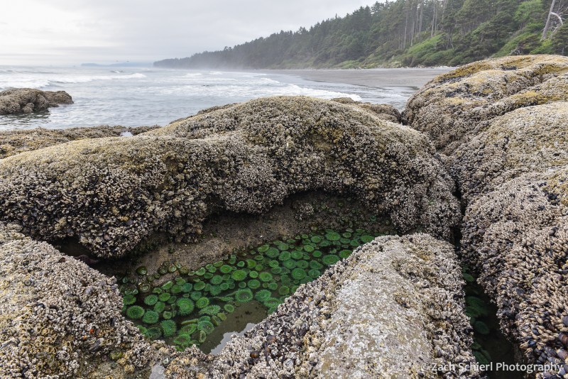
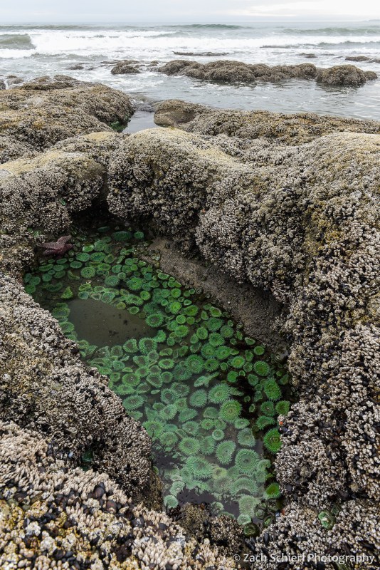
A tidepool filled with giant green anemones (Anthopleura xanthogrammica) along the coast of Washington in Olympic National Park.
Living in the desert of central Washington, it can be easy to forget that we live in a state with over 3,000 miles of coastline. While the high volcanic peaks of the Cascades are visible from our backyard (and thus remind us of their presence daily), the damp shores of the Pacific remain out of sight and out of mind most of the time.
Our most recent summer trip took us all the way to Washington’s western edge for a short backpacking trip along the coast in Olympic National Park. Coastal backpacking comes with a few unique challenges. For starters, predicting the weather along the coast is notoriously difficult, in part due to the relative lack of surface weather observations over the eastern Pacific and Gulf of Alaska, where most of our storm systems approach from. This fact ended up rearing its head on the final night of our trip.
Perhaps even more importantly, safe coastal backpacking requires that you know how to read a tide chart. The Washington coast experiences a fairly large tidal range, up to 10-12 feet during certain parts of the month. That’s enough to make vast sandy beaches completely disappear. A successful trip requires acute awareness of the timing and magnitude of the twice-daily high and low tides. The coast features many headlands (rocky outcroppings that jut out into the sea, often without any sort of “beach” whatsoever) that can only be traversed when the tide is below a certain level. Getting the timing wrong can (at best) result in having to sit on the beach for hours waiting for the tide to go out or (at worst) getting trapped in a dangerous situation as the tide rises and cuts off your escape route.
As this would be our first coastal backpacking trip, we obtained a permit for a fairly short and straightforward route beginning at Rialto Beach, heading north past the famous Hole-in-the-Wall, and eventually camping for two nights on the beach near the Chilean Memorial, the site of a shipwreck that killed 18 sailors all the way back in 1920. The terrain along this section of the coast was quite variable, ranging from long stretches of soft, sandy beach, to the slightly more annoying cobble and pebble beaches, to large boulder fields and headlands that were somewhat difficult to navigate with a heavy backpack:
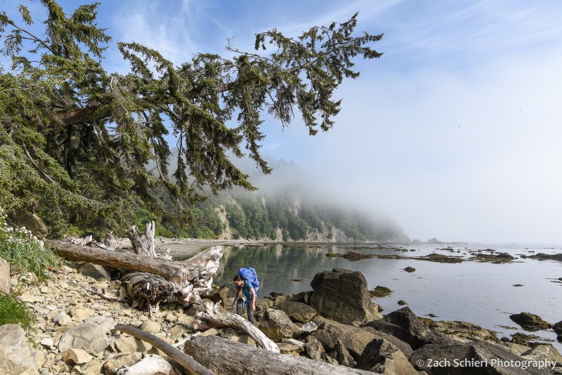
Picking our way along the rocky Olympic coast en route to our campsite at Chilean Memorial.

Tilted layers of sediment have been planed off by wave action near Hole-in-the-Wall, Olympic National Park, Washington.

Cape Johnson, Olympic National Park, Washington. With not much beach to speak of, this is a great example of a spot where being aware of the tide situation is essential!
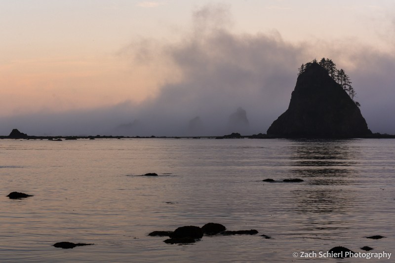
After a little more than four miles of hiking, we arrived at the small, unnamed cove home to the Chilean Memorial and found a campsite just above the high-tide line among large pieces of driftwood. This sheltered cove made for a relatively quiet and peaceful camp, as the myriad rocks and sea stacks just offshore caught the brunt of the surf, limiting the amount of wave action reaching the beach. We enjoyed watching the landscape of the cove change over the next few days as the mist and tides repeatedly swallowed up and revealed the sea stacks and small rocky islands. We quickly discovered that the largest sea stack (pictured below) was connected to the mainland via a rocky isthmus at low tide, and ended up hiking out to it one evening to look back on our campsite.
View out into the Pacific Ocean at sunset from our campsite on the Chilean Memorial beach in Olympic National Park, Washington

Looking back toward the Chilean Memorial beach and Cape Johnson from the base of the large sea stack in the previous photo.
While we had our fair share of clouds and mist, it did clear up enough on one evening to reveal the night sky. The moon was just past full, so the Milky Way was only barely visible, but it was still fun to see the southern stars rise and set over the Pacific:
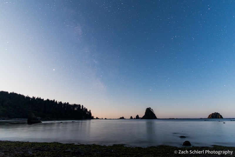
A faint hint of the Milky Way reveals itself despite the light cast by the rising moon (just behind the trees at left).

Enjoying a driftwood campfire on the beach.
Our trip came just a few days after the full moon, meaning that the low tides were some of the lowest of the month. These so-called “negative tides” are the best for exploring tide pools along the coast, as they reveal a greater variety of sea squishies:

Two giant green anemones in a tidepool in Olympic National Park, Washington.

A crowded tidepool containing multi-colored aggregating anemones (Anthopleura elegantissima) in Olympic National Park, Washington
A tidepool filled with giant green anemones along the coast of Washington in Olympic National Park.
In addition to the living tidepool organisms, we also observed large quantities of dead jellyfish (at least three different species) washed up on the beaches, including several massive (~2 foot wide) lion’s mane jellies:

A deceased (?) lion’s mane jellyfish (Cyanea capillata) washed up on the beach in Olympic National Park, one of many, many such jellies we found on our trip.
For our third and final night, the original plan was to hike most of the way back to the car and camp along Rialto Beach near Hole-in-the-Wall. Prior to departure, the weather forecast for this night had called for a fairly robust storm coming in off the Pacific. With an ailing tent that has become somewhat more, shall we say, permeable than one would desire, we briefly debated whether to just call it quits to avoid the chance of getting soaked. Surprisingly, we were able to get enough cell service on the beach to check an updated weather forecast, which showed a drastically reduced chance of rain and little precipitation expected. Consequently, we decided to stick with the original plan and set up camp in the trees at the north end of Rialto Beach. Our decision to stay was quickly validated as we observed a number of whales spouting and breaching throughout the afternoon just offshore.

Our final campsite along Rialto Beach. From this vantage point, we saw a number of whales (likely humpbacks) spouting and breaching off-shore throughout the afternoon and evening.
12 hours later, at 3 AM, when I was emerging from the tent for the third time to re-secure our tarp and shelter in the face of driving rain, wind, and large, deafening waves crashing up against the bluff just a few feet from our tent, I wasn’t so sure. A great example of the fickle coastal weather I suppose, and a good character building experience as Calvin’s dad would say.
While intense, the storm was brief, and by morning the skies were clearing, making for a pleasant stroll down Rialto Beach back to the car. All in all, the trip was a refreshing change of scenery from our predominantly mountain-based adventures the rest of the summer!

Benign clouds greeted us in the wake of the storm for our short hike out to the car on the final morning.
Monterey, California: Famous for the Coast, Famous for the Cheese

Sunset at Fort Ord Dunes State Park
Did you know that Monterey Jack cheese takes it’s name from the city where it was first made by Spanish settlers and then later first commercially marketed by a Scottish immigrant? Neither did I. That is, until I came across a lovely, if somewhat small and water-logged (and apparently created on a home inkjet printer…) interpretive sign informing me of that fact on a recent hike to the top of the peak that now bear’s Jacks’ name:

The Sign
Located just outside of Monterey, CA, Jacks Peak is the highest point in Monterey County topping out at a whopping 1,068 feet above sea level. The sign left me curious, and wanting to learn more about this mysterious Jacks fellow and his delicious cheese. After much additional research, I am now able to present you with the following information:
1. There is actually a fair bit of ongoing, spirited debate over who exactly should be credited with first making “Monterey jack” cheese. And Julius Caesar is involved…somehow.
2. According to the Monterey County Historical Society, Monterey jack is one of just four varieties of cheese to have been invented (created? first made? can one really “invent” cheese?) in the United States. In other words, while the U.S. may be top dawg at spitting out fancy new electronic devices that start with a lower case “i”, we are seriously lacking when it comes to new innovation in the field of dairy products.
3. Due to it’s creamy texture, Monterey Jack is excellent for making grilled cheese sandwiches.
I probably could have kept this list going for a while but reading page after page about cheese made me hungry. Lacking any authentic Monterey jack, I instead “settled” for a large hunk of Tillamook aged medium white cheddar, a piece of cheese that was so tasty I seriously considering including a picture of it right after this period. In fact, I still am considering it.
Monterey is also famous for a number of other attractions, nearly all of which, sadly, have little or nothing to do with the cheese that so admirably and bears the city’s name. Most of them do, however, involve the ocean in some way or another which is a pretty good consolation prize if you ask me.

A boardwalk snakes through a field of invasive ice plant at Fort Ord Dunes State Park
Fort Ord Dunes State Park is one of the newer such attractions. Not new in the sense that the beach or the dunes itself are new (they’re quite old actually) but new in the sense that the land it occupies was for many years part of the Fort Ord U.S. Army post. In 1994, the Fort was closed and since then much of the land has been reclaimed and opened to recreational use. Over 10,000 acres were set aside by President Obama as Fort Ord National Monument 2012. A small strip of the beach and adjacent dunes just north of Monterey became Fort Ord Dunes State Park (pictured above) in 2009.

Looking south along the California coast from Point Lobos State Reserve
Clear on the other side of town is Point Lobos State Reserve, also part of the California State Park System. The scenery at Point Lobos is breathtaking to put it mildly. In slightly more concrete terms, it was WELL worth the drive back into town to withdraw some cash so we could pay pay the cash-only $10 entry fee to the park. Now, you can also park on the highway and walk in for free but in my humble opinion, $10 is a small price to pay to keep one of the most spectacular stretches of coastline in the world preserved for all to see. Like the nearby, and arguably more famous, 17-mile-drive and Pebble Beach area, the Point Lobos reserve protects rugged and rocky stretches of coastline, sheltered coves home to seals, sea lions, and sea otters, and one of the last remaining stands of Monterey cypress. What you won’t find here though is multi-million dollar mansions and immaculately manicured golf courses dotting the coast which in my view improves the scenery to a level that is beyond my ability to communicate via words.

One of only two remaining groves of Monterey cypress (Cupressus macrocarpa) trees on Earth, Point Lobos State Reserve

Wispy cirrus clouds hover above Lover’s Point in Monterey, CA

The hoards enjoy a beautiful winter sunset from Carmel Beach
Last but not least is Carmel Beach, located in the small hamlet of Carmel, which is distinctive in that it eschews street lamps and prohibits the wearing of shoes with heels higher than two inches. It is also one of the few towns in the U.S. to forgo street numbers. While you mull on that for a bit, take note that Carmel Beach is oriented almost directly towards the late afternoon sun, making it an ideal location to spend the end of your day watching our local nuclear fusion reactor dip below the apparent horizon of the Earth (that’s a more astronomically correct way of saying “sunset”). Note also that you won’t be alone. No matter though, just bring a blanket, a box of crackers, and some cheese and enjoy the show!

Sunset at Carmel Beach
