Monterey, California: Famous for the Coast, Famous for the Cheese

Sunset at Fort Ord Dunes State Park
Did you know that Monterey Jack cheese takes it’s name from the city where it was first made by Spanish settlers and then later first commercially marketed by a Scottish immigrant? Neither did I. That is, until I came across a lovely, if somewhat small and water-logged (and apparently created on a home inkjet printer…) interpretive sign informing me of that fact on a recent hike to the top of the peak that now bear’s Jacks’ name:

The Sign
Located just outside of Monterey, CA, Jacks Peak is the highest point in Monterey County topping out at a whopping 1,068 feet above sea level. The sign left me curious, and wanting to learn more about this mysterious Jacks fellow and his delicious cheese. After much additional research, I am now able to present you with the following information:
1. There is actually a fair bit of ongoing, spirited debate over who exactly should be credited with first making “Monterey jack” cheese. And Julius Caesar is involved…somehow.
2. According to the Monterey County Historical Society, Monterey jack is one of just four varieties of cheese to have been invented (created? first made? can one really “invent” cheese?) in the United States. In other words, while the U.S. may be top dawg at spitting out fancy new electronic devices that start with a lower case “i”, we are seriously lacking when it comes to new innovation in the field of dairy products.
3. Due to it’s creamy texture, Monterey Jack is excellent for making grilled cheese sandwiches.
I probably could have kept this list going for a while but reading page after page about cheese made me hungry. Lacking any authentic Monterey jack, I instead “settled” for a large hunk of Tillamook aged medium white cheddar, a piece of cheese that was so tasty I seriously considering including a picture of it right after this period. In fact, I still am considering it.
Monterey is also famous for a number of other attractions, nearly all of which, sadly, have little or nothing to do with the cheese that so admirably and bears the city’s name. Most of them do, however, involve the ocean in some way or another which is a pretty good consolation prize if you ask me.

A boardwalk snakes through a field of invasive ice plant at Fort Ord Dunes State Park
Fort Ord Dunes State Park is one of the newer such attractions. Not new in the sense that the beach or the dunes itself are new (they’re quite old actually) but new in the sense that the land it occupies was for many years part of the Fort Ord U.S. Army post. In 1994, the Fort was closed and since then much of the land has been reclaimed and opened to recreational use. Over 10,000 acres were set aside by President Obama as Fort Ord National Monument 2012. A small strip of the beach and adjacent dunes just north of Monterey became Fort Ord Dunes State Park (pictured above) in 2009.

Looking south along the California coast from Point Lobos State Reserve
Clear on the other side of town is Point Lobos State Reserve, also part of the California State Park System. The scenery at Point Lobos is breathtaking to put it mildly. In slightly more concrete terms, it was WELL worth the drive back into town to withdraw some cash so we could pay pay the cash-only $10 entry fee to the park. Now, you can also park on the highway and walk in for free but in my humble opinion, $10 is a small price to pay to keep one of the most spectacular stretches of coastline in the world preserved for all to see. Like the nearby, and arguably more famous, 17-mile-drive and Pebble Beach area, the Point Lobos reserve protects rugged and rocky stretches of coastline, sheltered coves home to seals, sea lions, and sea otters, and one of the last remaining stands of Monterey cypress. What you won’t find here though is multi-million dollar mansions and immaculately manicured golf courses dotting the coast which in my view improves the scenery to a level that is beyond my ability to communicate via words.

One of only two remaining groves of Monterey cypress (Cupressus macrocarpa) trees on Earth, Point Lobos State Reserve

Wispy cirrus clouds hover above Lover’s Point in Monterey, CA

The hoards enjoy a beautiful winter sunset from Carmel Beach
Last but not least is Carmel Beach, located in the small hamlet of Carmel, which is distinctive in that it eschews street lamps and prohibits the wearing of shoes with heels higher than two inches. It is also one of the few towns in the U.S. to forgo street numbers. While you mull on that for a bit, take note that Carmel Beach is oriented almost directly towards the late afternoon sun, making it an ideal location to spend the end of your day watching our local nuclear fusion reactor dip below the apparent horizon of the Earth (that’s a more astronomically correct way of saying “sunset”). Note also that you won’t be alone. No matter though, just bring a blanket, a box of crackers, and some cheese and enjoy the show!

Sunset at Carmel Beach
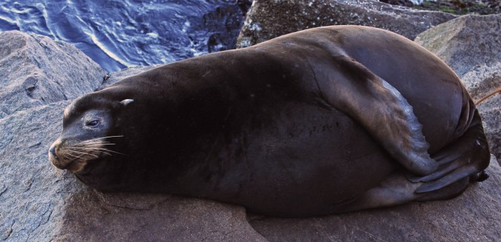
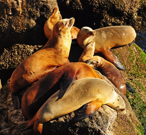
Sleepy Seals and Sea Lions
I’ve tried napping on rocks before. Apart from a nice long snooze on a flat, polished slab of gneiss along the Gunnison River this summer, I haven’t had a whole hell of a lot of success, but that’s a story for another day. After much thought, I can see only two possible ways in which one could enjoy a nice long nap on a rock: #1: you have an air mattress and pump with you (or a really thick ThermaRest), or #2: your internal organs are cushioned by a several inch thick layer of blubber. This collection of photos of seals and sea lions getting their beauty sleep in some seemingly uncomfortable positions deals predominantly with option #2. These creatures all call Monterey, CA their home and are content to take a siesta on just about any exposed knob of rock they can find. Either that or somebody accidentally dumped a semi-truck load of Ambien into the bay. Anyways, in summary, my quest to use the word “blubber” in a blog post is now complete and I’ll be going to bed now. In a nice, warm, soft, mostly level but with a slight sag in the middle, Queen-sized bed mind you.

Spotted Seal? Or moldy sausage?

Don’t let the passive appearance of this adorable sea lion fool you! Just moments later this enormous pile of blubber was actively trying to bite off a rivals head!

It’s really funny when the one on the bottom wakes up first
Can’t….keep….eyes….open…


Sea lions behave much like a viscous fluid; they take the shape of their surroundings.
The World’s Most Spectacular Meeting of Land and Sea: Big Sur, California

Big Sur coast looking south from Julia Pfeiffer Burns State Park
We interrupt the recent Colorado-centric nature of this website to bring you an important dispatch from the western shore of the North American continent, also known as the Golden State of California.
On a recent visit to Monterey, CA to visit my girlfriend, we decided to drive south along the famed Pacific Coast Highway and spend a night in the Big Sur region of central California. To invert the timeless words of Douglas Adams: “this has been widely regarded as a good move.” The local tourism bureaus like to tout the area as “The world’s most spectacular meeting of land and sea”. While I generally get somewhat uncomfortable and squirmy around such subjective superlatives, there is no denying that at Big Sur, the land does indeed meet the sea; as exemplified by the fact that, on more than one occasion, I would have quite easily been able to walk directly from solid earth into the ocean, had I chosen to do so. I didn’t choose to do so but the point is that I could have and I imagine it would have been quite a spectacular meeting if I had. Maybe next time.

Partington Cove, Big Sur

McWay Falls, Big Sur
The Big Sur region is home to a plethora of beautiful and intriguing attractions, of which we had time to sample only a smattering. California Highway 1 meanders its way through Big Sur, rarely in a manner which permits one to safely exceed 30 miles per hour, but almost always in a manner which provides spectacular views of the jagged coastal cliffs along the Pacific Ocean below. Fortunately, pullouts are ample, thus avoiding the need to try and enjoy the view while simultaneously keeping the car from punching through the guardrails and plunging into The Sea.
One of the highlights is Juila Pfeiffer Burns State park, home to a 80-foot high waterfall that plunges into an aquamarine cove surrounded on three sides by ragged sea cliffs. Big Sur also marks the southern extent of the range of the Coast Redwood. Although these trees are not nearly as large or prevalent here as they are further north along the California coast, small gulches and canyons along the coast harbor small, yet impressive groves of these stately conifers.

Michelle admiring the redwood trees along the Canyon Trail in Julia Pfeiffer Burns State Park.
From the “proof that spending time amongst a large quantity of tourists is never boring” department, I present the following tale as a humorous anecdote. Looking at the above pictures, It doesn’t exactly take a trained eye to notice that the natural environment of the Pacific Coast is wholly different than just about anywhere else in the country. Nevertheless, while milling about a trailhead in Julia Pfeiffer Burns State Park, I had the pleasure of overhearing an exchange between two other groups of hikers in which one group proudly informed the other that “this place really reminds us of the time we visited the red rocks in Sedona, Arizona. It’s amazing how similar it looks.” For those of you unfortunate enough to not be familiar with Northern Arizona, Sedona looks ABSOLUTELY NOTHING like the above pictures but instead more like this.
Lest you doubt my incredulity over the above comparison, let’s do a brief comparison of the landscapes shall we:
Big Sur |
Sedona |
|
|
Color of rocks |
Everything but red |
Red |
|
Vegetation |
Coast Redwoods, Monterey Pine, Laurel, Oak |
Pinyon pine, juniper, sagebrush, manzanita, cacti |
|
Ocean |
Yes |
Yes, 300 million years ago |
|
Annual precipitation |
42 inches |
19 inches |
|
Commonly observed fauna |
Seals, otters, whales, evil seagulls |
Squirrels, javelina, rattlesnakes |
|
Elevation |
Duh…it’s the sea |
4,300 feet |
|
Geologic features |
Sea cliffs, sea arches, mountains, waterfalls |
Buttes, mesas, canyons, plateaus |
|
Extremely pricy resorts and hotels |
Yes |
Yes |
|
Highway frequented by excruciatingly slow RV’s |
Yes |
Yes |
Alright, so maybe there are some similarities after all. But not the kind that would lead one to compare a wet, foggy shoreline to a labyrinth of redrock canyons and mesas in the middle of a desert. I wanted to say something along the lines of “what have all y’all been smoking?” or “excluding hallucinations, have you ever actually BEEN to Arizona?” but I kept my mouth shut and moved on.
And last but not least, enjoy a few pictures of the native inhabitants of the area:

Sea otter in Monterey Bay willing to work for his/her afternoon snack. We watched this otter floating on his back cracking open various sea critters for a good twenty minutes.

A bloom (or swarm…experts seem to disagree on the proper term for a group of jellyfish) of aquarium-bound jellyfish. We saw a whole bunch of these floating in the ocean from a pier in Monterey which sort of made me never want to go in the ocean again.
