Exploring the Mt. Adams Wilderness


Mt. Adams is the largest (by volume) and second highest volcano in the Cascade Range of Washington. Often overshadowed by its neighbors, Mt. Rainier, Mt. St. Helens, and Mt. Hood, we’ve taken a liking to Adams in part because its trails tend to be relatively deserted and in part because we have a fantastic view of the mountain’s east face from our neighborhood in the Yakima Valley. Recently we had the chance to complete a short backpacking trip on the north flank of the mountain which allowed us vantage points that far surpass anything we’ve seen on previous day hikes.
Our hike began and ended at a trailhead (Killen Creek) that is, as the crow flies, just 57 miles from our front door, but takes more than three hours to reach by car, giving some sense as to the relative remoteness of this area. Most of our ~20 mile loop was within the Mt. Adams Wilderness, a 48,000 acre wilderness area designated in 1964 with the original passage of the Wilderness Act.

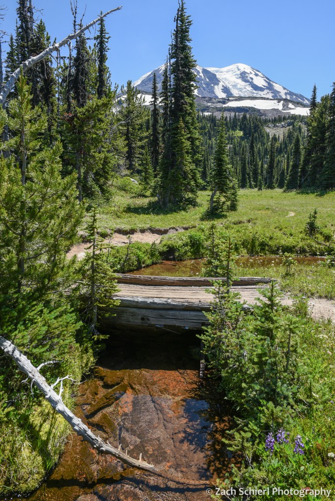
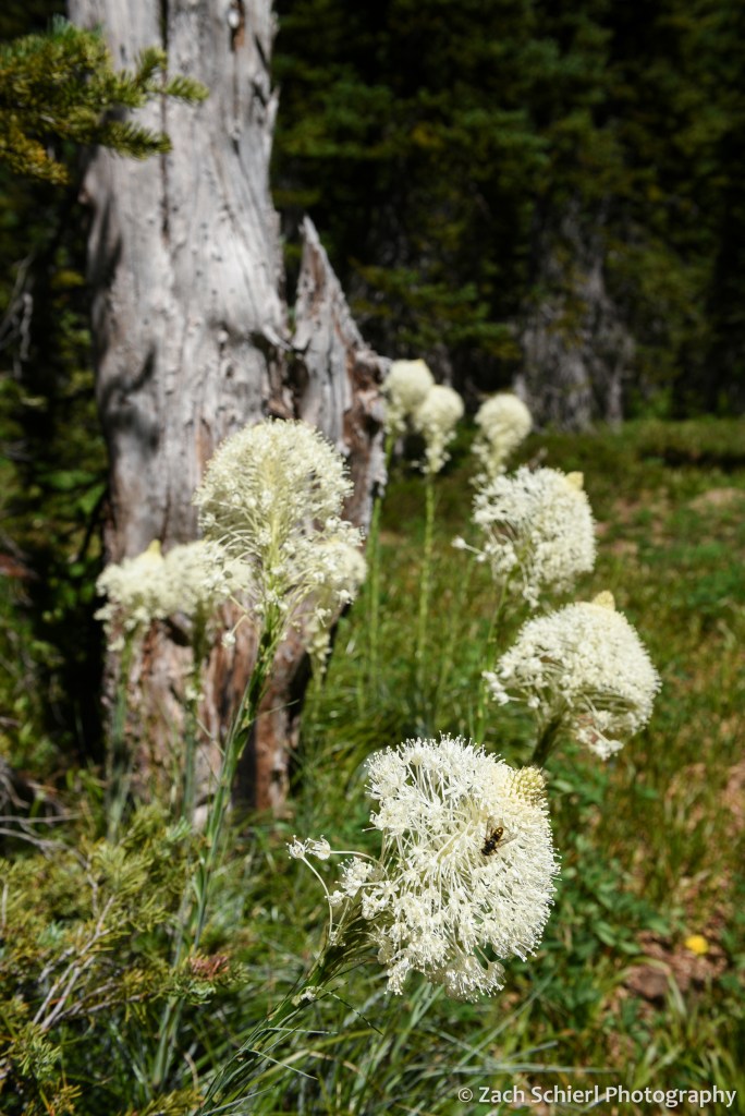
On our first night, we camped at just under 7,000 feet on the north flank of the mountain in one of the most spectacular alpine meadows I’ve seen. No matter which way I turned, the views were extraordinary. To our south, the crumbling volcanic edifice of Mt. Adams loomed large, with the Adams Glacier descending in a stunning icefall from the summit plateau. To the north, broad expanses of dense evergreen forest stretched off into the distance, leading the eye to the massive Mt. Rainier and the rugged skyline of the Goat Rocks on the horizon. To the west, the truncated cone of Mt. St. Helens was backlit by the setting sun. Several lingering snowfields surrounded our campsite, providing a nice source of clear, cold water. A variety of diminutive alpine wildflowers were in full bloom, and the low rumble of rock and ice fall high on the mountain occasionally punctuated the silence, with clouds of dust the only clue as to their location. While this location is reachable by a long day hike, spending the night and being able to explore and photograph in the late afternoon and evening light is one of my favorite things about backpacking!


On Day 2, we descended to the Pacific Crest Trail before working our way around to the northeast side of Mt. Adams, passing through a series of wildflower-filled meadows and crossing several inviting streams cascading down from melting snowfields and glaciers higher on the mountain. These meadows also hosted a robust population of mosquitos and other biting insects….not unexpected for the Cascades in July, but an annoyance nonetheless, especially for an Arizona-born desert rat like me!

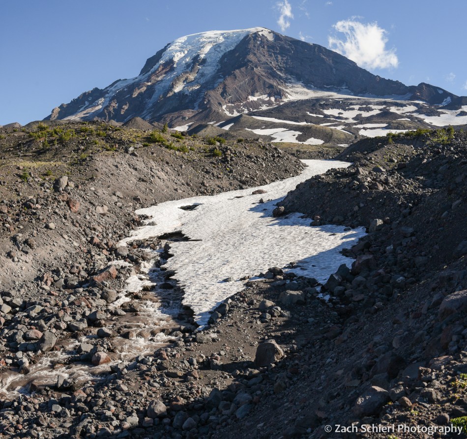
We had shared the trail with quite a few other hikers and backpackers on Day 1, but saw only a few other people from this point forward. Camp on night two was in a small clump of trees on the edge of a relatively recent lava flow. In contrast to the verdant alpine meadows of night one, this landscape was much more rugged, barren, and stark. After setting up our tent, we proceeded up the trail (with much lighter packs!) to find a spot for dinner. We quickly arrived at a stream crossing that we didn’t feel comfortable fording, so we left the trail behind and proceeded to pick our way up the rubbly bank until we arrived at a small knob with a spectacular view of the glaciers on Mt. Adams’ northeast face (Lava, Lyman, and Wilson). Here we enjoyed a delicious meal of instant mashed potatoes mixed with green chiles and an entire bag of bacon bits while listening to the roar of the creek.
Our best wildlife sighting of the trip actually occurred on the drive to the trailhead, when we happened upon a young barred owl sitting in the road. As we approached it flew into a nearby tree where it watched us warily for a few minutes before fleeing deeper into the forest:

Aside from this, we saw surprisingly little wildlife on this trip (unless you count mosquitos): only a few birds, chipmunks, squirrels, and a single marmot and mountain goat in the far distance from our first camp.
From our second camp, we were in a great position to catch sunrise on the final morning of our trip. There aren’t many things I’ll get up at 5:15 am for, but a Mt. Adams sunrise is definitely one of them!

After packing up, we hiked the eight downhill miles back to our car and drove back into the 100 degree blast furnace that is the Yakima Valley in late-July. We are thankful to have beautiful places like Mt. Adams so close to escape the heat this time of year!
Europe Part 7: Into the Albanian Alps

Links to previous posts: Part 1, Part 2, Part 3, Part 4, Part 5, Part 6
Albania wasn’t on our itinerary when we first sketched out this trip four years ago. Our flight back to North America would be departing from Rome, so we needed to get across the Adriatic Sea to Italy at some point. We didn’t want to retrace our steps back to Zagreb or Ljubljana, so we initially thought about continuing south to Greece and flying back to Rome from Athens. At some point during our trip planning though, we ran across some YouTube videos of people backpacking in the Albanian Alps and pretty quickly decided that we wanted to fit them into our itinerary. Plus we found some cheap flights from Tirana (Albania’s capital) to Rome, so Albania it was!
Albania is a fascinating nation with a history that sets it apart from the surrounding countries that we visited. The only country on our trip not part of the former Yugoslavia, Albania experienced a more isolating and brutal form of communism than its Yugoslav neighbors to the north. From 1944 to 1985, Albania was controlled by the dictator Enver Hoxha, and was almost entirely isolated from the international community, unlike the relatively open Yugoslavia. Communism fell in Albania in the early 1990s, and today it is a democracy, albeit a fledgling one. Arriving in Albania was definitely a little bit of a culture shock, even after almost a month of travelling. After three weeks of seeing Serbo-Croatian languages everywhere, we knew or at least recognized a lot of words so it was becoming a bit more familiar. Albanian is completely different, so it was sort of like starting the trip all over again. English was also widely spoken in the former Yugoslav republics (I swear the Slovenians spoke English better than we do…) but this was definitely not the case in Albania, especially in the more rural parts. There exists only a single guidebook for Albania, and overall it was much harder to find information and plan things in advance.
After out brief stop in Shkoder, we embarked on the final leg of our trip: a five day tour through the rugged Albanian Alps, also known as the Accursed Mountains. Our plan was to take minibuses and a ferry to the Valbona Valley, stay there for two nights, then hike over Valbona Pass to the village of Theth, where we would spend a few more nights before taking another minibus back to Shkoder and eventually Tirana to begin our journey home. While we were already travelling pretty light, we would need to carry all of our belongings with us over Valbona Pass so we ended up leaving some stuff behind at our hotel in Shkoder and picking it up on our way back through five days later.
We departed at 6:30 am on a minibus, the primary mode of public transportation in Albania. The minibus drove around Shkoder for close to an hour picking up other people until the bus was full, then we headed out of town and quickly started climbing up into the mountains. Our destination was the Komani Lake ferry terminal. The Valbona Valley, while not far from Shkoder as the crow flies, is not easy to get to. One option is an all day drive that apparently involves crossing the border into Kosovo and then back into Albania. Option 2 involves a two-hour drive to Komani Lake, followed by a 3-hour ferry ride, and then another minibus for the final hour to Valbona. We opted for the latter and a few hours after departure from Shkoder arrived in the tiny and very rural town of Komani. From here, the road, which had been very rough dirt for the last hour, was suddenly paved and lined with a sidewalk and streetlights. The road climbed up a steep grade littered with rockfall before entering a small tunnel bored into the side of the mountain. About halfway through the tunnel, cars and buses were stopped in the road letting people out. Our bus somehow managed to squeeze past a bunch of them (if you had asked me whether this tunnel was wide enough for two mini buses to pass each other, I would have said “hell no”), but eventually had to stop as well. We got out of the bus, grabbed our stuff, and walked out through the end of the tunnel, which emerges at the base of a huge cliff next to a ~30×30 foot patch of pavement wedged between the cliff face and the shoreline of Lake Komani, which is actually a reservoir.

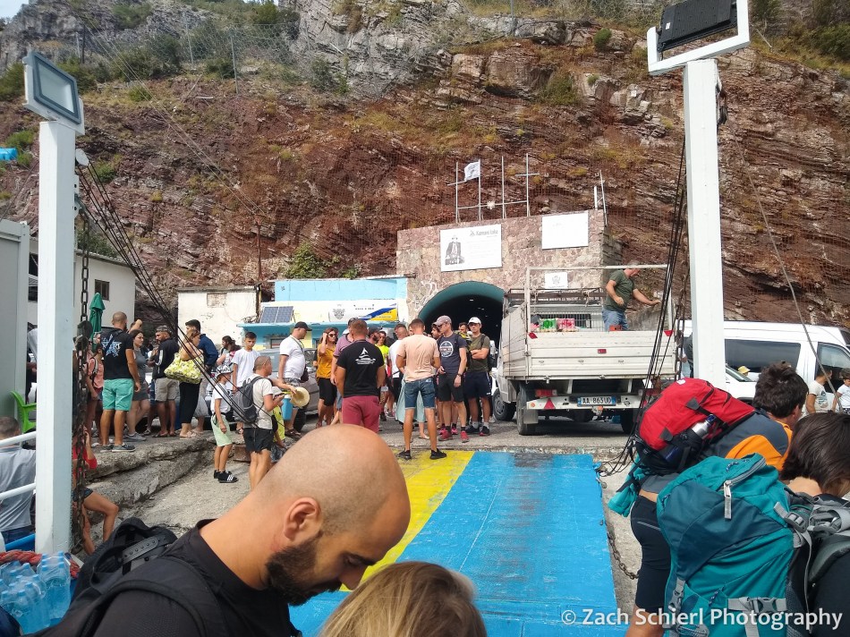
This was the ferry terminal and it was absolute chaos…probably the craziest scene I have experienced while travelling. It was jam packed with people, minibuses, full size buses, luggage, cars and trucks trying to get on (or off) one of more than a dozen boats of various sizes that were jostling for space along the shore. It was pretty wild. We pushed our way forward to the largest boat, Ferry Berisha (fun fact: named for a former prime minister and president of Albania who was banned from entering the U.S. in 2021 because of “involvement in significant corruption”), on which we had, in theory, paid for the trip in advance. The ferry employees didn’t seem to have any record of that though, and after a few minutes of trying to translate our argument into Albanian, they just let us on, probably just to keep the line moving more than anything else. The ferry was relatively small, with about 10 cars on the lower deck and a small passenger deck above with seats. The passenger seats were already quite full by the time we boarded so we ended up plopping down on the lower deck next to the cars. We estimated that there were well over a hundred people on the ferry and were somewhat surprised to see so many people headed to such a remote part of Albania. I guess we shouldn’t have been…after all, we found out about this area from a YouTube video. Mass tourism spares no corner of the world these days.
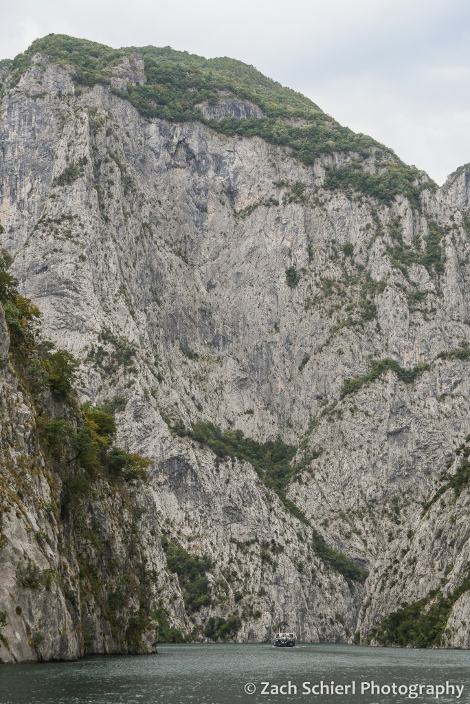
The ferry ride was very scenic, and reminded me a lot of the Black Canyon of the Gunnison in Colorado (specifically the Morrow Point Reservoir section where the National Park Service runs a boat tour.) Komani Lake is a very narrow reservoir that winds deeper and deeper into the Albanian Alps, with several thousand foot cliffs coming right down to the water in many spots. There were a number of small villages and houses along the shores that are apparently accessed only via ferry.

The ferry terminal where we disembarked was not quite as chaotic. Basically there were just a ton of mini buses standing ready to shuttle people the last hour to Valbona. Neither of us remember the drive that clearly because we were both nodding off. We were eventually dropped off at Guesthouse Demushi, our home for the next two nights. The setting was gorgeous. The guesthouse was on a mini-farm with a garden, fruit trees, flowers, lots of chickens running about, and, of course, stunning views of the high peaks in the Albanian Alps.

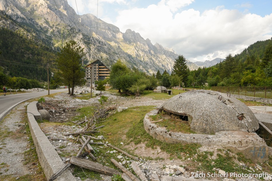
Valbona is not really a town per se, but rather a bunch of homes, farms, and guesthouses strung out along several miles of the Valbona River Valley. The road into the valley dead ended a few miles up valley from our guesthouse, turning into a hiking trail that we would take to Theth a few days later. Valbona was an incredibly beautiful albeit very perplexing place. We struggled to find a comparison to anywhere we’ve visited before. For starters, we weren’t quite sure where everyone that was on the ferry went, because the valley felt pretty deserted. There were a ton of little guesthouses (some with restaurants) scattered throughout the valley, but no other tourist infrastructure whatsoever: no stores, gas stations…nothing. The entire area is a national park, though if we hadn’t read that in advance, I don’t think we would have known. There is certainly no visitor center, and barely any signage whatsoever. It seemed like half the valley was under construction. There were a lot of half finished buildings (including a monstrosity of a hotel that seemed more out of place than any building I’ve seen in my life), many of which looked like they hadn’t been worked on in quite some time. The roadside and yards were also littered with decomposing, round, concrete bunkers, left over from Albania’s communist days when Enver Hoxha was paranoid about an attack and had several hundred thousand prefabricated bunkers built across the country. Sadly, there was also a ton of trash everywhere. It sort of felt like someone decided to build a little mountain resort town and then just abandoned the project halfway through. All in all, the built environment felt wildly incongruous with the natural setting.

The Valbona Valley is in extreme northern Albania, just a few miles from Montenegro and a few miles from Kosovo. After getting our bearings, we were excited to do some hiking the following day, however we struggled to find reliable information on hiking trails in the area or a weather forecast. My CalTopo mapping app showed a handful of trails, but I’m always loathe to rely entirely on electronics, especially in an unfamiliar area. (Oddly, we had full LTE cell service throughout the valley.) We couldn’t find a paper map, because the only person in the valley who sold them has apparently disappeared from the face of the Earth (a story for another time…)
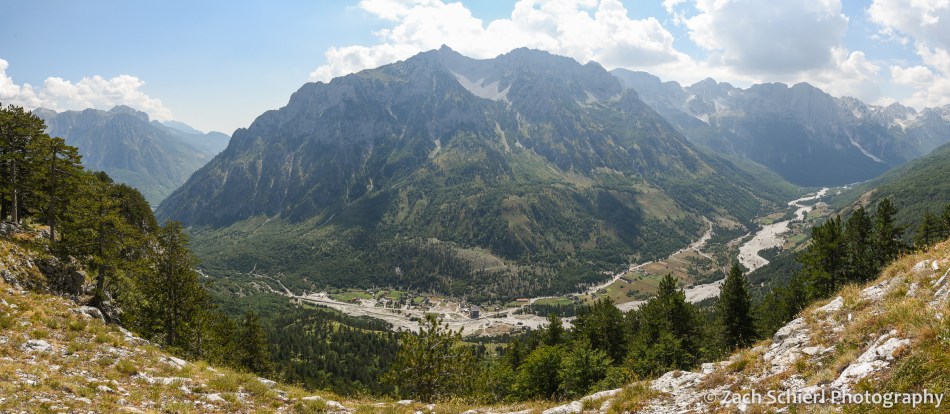
We ended up hiking a loop trail that a waiter had mentioned the night before at dinner, only part of which appeared on my digital map. The hike began with a gentle ascent to the village of Kukaj, perched a few hundred feet above the main valley in a little side drainage. From Kukaj, the hike got quite steep and we sweatily labored our way up the valley wall until we arrived at an amazing viewpoint where we could look both up and down the Valbona Valley. (See photo at top of post.) We spent close to an hour here enjoying the view before completing the loop and descending back to the valley floor. We got back the guesthouse not long before a pretty intense thunderstorm (and brief power outage) rolled through the valley.

The next day it was time to head across Valbona Pass to Theth! This day happened to be our 6th wedding anniversary, a date on which we’ve had some interesting adventures the last few years. In 2019 we rode a shuttle bus in Glacier National Park that ended with us filing a formal safety complaint with the National Park Service, then proceeded to nearly lose a wheel on our own car, necessitating a cross-border trip to a NAPA Auto Parts store in Cardston, Alberta. In 2020 we had a brush with hypothermia on a backpacking trip near Glacier Peak, only to return to our car and find that mice had trashed it during the few nights it was parked at the trailhead. In 2021 we were on a whitewater rafting trip on the Rogue River in Oregon, which actually went quite well save for the suffocating wildfire smoke that has become so common in late summer.
The day started with a delicious breakfast at Guesthouse Demushi, consisting of bread, butter, cheese, jam, eggs, etc…very traditional, tasty, and filling. After breakfast, we got a ride to the end of the paved road to save us a few miles of walking. We started early as we weren’t quite sure how long of a hike we had in store. Distance estimates we had seen online varied wildly, and while the route was well signed, like most other countries in Europe, Albanian trail signs give distances in hours, as opposed to, you know, an actual unit of distance like kilometers or miles. (As a former park ranger who has seen first hand the wide range in personal hiking speeds, this drives me crazy to no end!) Our best estimate was 8-10 miles.
It was a cool, overcast, and humid morning as we walked the mostly flat, gravelly river bottom for the first few miles to the village of Rragram. After Rragram, the grade started to steepen. While it was still overcast and fairly cool, it was extremely humid and I’m not sure if I’ve ever sweat so much in my life. Times like these make me grateful that we live in the desert! Before too long we arrived at one of two small cafes found along the trail. This has to be the ultimate paradox of hiking off the beaten path in Europe: it’s almost impossible to find out how long the trail actually is, but you can still buy a cold beer every few miles. Quite surreal. This first cafe had a thatched roof of leaves, a wide selection of cold drinks cooled by a natural spring, and a plush bathroom with an ornate running water system. (Prices for those drinks were the highest that we had seen since London, which I guess makes sense. Generally speaking, prices in Albania were quite low. Dinner for two with drinks set us back the equivalent of about $20 most nights. A soda here at the cafe was $5.) We enjoyed two sodas even though it was not yet 9 am, to replace the many electrolytes we had lost via sweat in the last two hours.
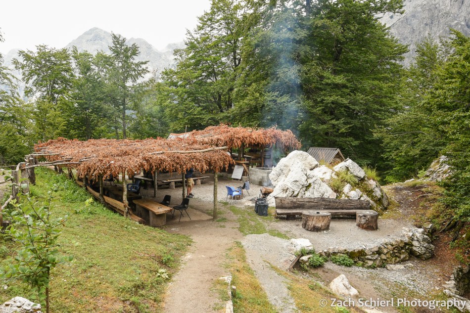
The trail from Valbona to Theth is without a doubt the most travelled in the Albanian Alps, but up until this point we had only seen one other group of people and were again starting to wonder where the heck everyone was. Apparently we were the early birds because while resting at the cafe, several larger groups caught up with us and we had plenty of company the rest of the day. After the cafe the hike got much more interesting as we began to ascend rocky slopes up toward the pass. The views really opened up and we could see back down the Valbona Valley towards where we had stayed the last few nights. Before we knew it, we were arriving at the pass, just as the clouds started to open up. Luckily we didn’t hear any thunder, but even so we didn’t stick around too long before beginning the descent to Theth. Half an hour later we arrived at cafe #2 where we waited out another heavy band of rain under a covered seating area while enjoying some fli, a traditional Albanian mountain pastry consisting of layers of Swedish-pancake-like dough with sugar and nuts.
From the second cafe it was a long, steep descent into Theth, mostly through dense beech forests with minimal views. In the final installment, more on Theth and our journey home!

Europe Part 2: The Julian Alps

From the beginning, Slovenia was one of the destinations that drew us to eastern Europe, specifically the Julian Alps in the western corner of the tiny country. Just south of the Austrian border, the Julian Alps are an eastern extension of the famous European mountain range that, while still well-visited, are more off-the-beaten path than the Swiss or Italian Alps.
After our stopover in London, we hopped a British Airways flight to the capital of Slovenia, Ljubljana (pronounced “lube-lee-ah-nah“). After sitting on the tarmac in London for awhile, we arrived just in time to pick up our only rental car of the trip, which we had reserved to facilitate a driving loop through the mountains in areas where public transportation was lacking. We were pretty tired and jet-lagged after several full days of travel, so it was probably good that: 1, Slovenians drive on the right and 2, that our first destination was only a 30 minute drive from the airport. As is par for the course with us, the “low tire pressure” indicator on our rental car illuminated less than 10 minutes into our late-night drive through the Slovenian countryside to Lake Bled, where we would be staying for the next three nights. A visual inspection revealed a tire that looked perfectly normal, so we pushed onward. (The light stayed illuminated for all five days that we had the car, but none of the tires were visibly flat so we rolled with it, literally and figuratively.)
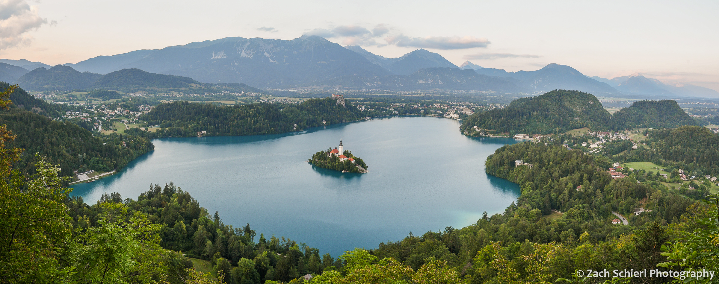
With nearly all of the Balkans to choose from, Josip Broz Tito, the president/dictator of the former Yugoslavia (which Slovenia was part of until 1991) chose Lake Bled as the location for his summer villa. It wasn’t hard to see why. Lake Bled was extremely beautiful and scenic, with deep blue water, a tiny island complete with picturesque church right in the middle, and a fairy tale castle perched on a cliff above the lake. The town of Bled, on the east shore of the lake, was quite busy, and overall the vibe reminded us of mountain towns like Aspen or Leavenworth (minus the castle). In what would be a theme of the entire trip, we encountered very few American tourists, but lots of English spoken, given that it serves as the default tongue for Europeans unfamiliar with each others’ languages.
Temperatures were toasty, in the high 80s to mid 90s, and the air was humid (by western US standards at least), so we spent as much time near or in the water as possible. We spent some time on the local swimming beach, and took a boat ride out to the island in the middle of the lake on a traditional wooden pletna rowboat:


Lake Bled sits at the foot of the Julian Alps and, despite the muggy conditions, we were determined to experience some of the fantastic hiking trails in the area. Our first hike took us on a short loop through the Pokljuka Gorge, a dry slot canyon carved into the ubiquitous limestone of the Julian Alps at the end of the last ice age. Exiting the slot canyon involved traversing a rickety little pathway bolted to the side of a cliff that I could have done without. The scenery was gorgeous though, and we encountered only a few others groups despite the proximity of the trailhead to bustling Bled.

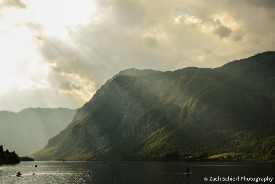
About 30 minutes up into the mountains from Lake Bled is the larger Lake Bohinj. We were under the impression that Bohinj was a quieter, less visited lake (one guidebook described it as “sleepy”), but the scene was just as nuts, if not more so, than Lake Bled. Despite some trouble finding parking, we ended up having a lovely swim in Lake Bohinj in the late afternoon. Neither Bled nor Bohinj allow motorized boats, which, despite the crowds, made both of them seem very tranquil and peaceful, in contrast to many similarly-sized lakes here in the US.
Later that evening, we rushed (literally) up to a spectacular overlook of Lake Bled from Mala Osojnica just in time for sunset (see photo at top of page). On our final morning in Bled, we drove about 30 minutes up into the mountains to hike Viševnik, a 2000 meter peak with amazing views of Triglav, the highest point in Slovenia. While only a few miles long, the trail shot straight up the side of the mountain, first along the margins of some ski slopes, then up a rocky chute, and then finally across broad grassy slopes with commanding views back toward Bled. We lost a few buckets of sweat, but the views of the sharp peaks hewn from bright white limestone were sublime. Thanks to a good map and well-signed trails, we were able to improvise a loop that took us on a more gradual descent back to the trailhead.

After a few days in Bled, we made the drive across the Julian Alps to the Soča River Valley via Vršič Pass. The gnarly road over the pass was built by Russian POWs during World War I to supply Austro–Hungarian troops on the front lines just over the pass. The road is narrow and steep, with 50 hairpin curves. We made a number of stops en route to admire the jagged peaks of the Alps and to let the engine (on the way up) and the brakes (on the way down) cool down a bit! On the downhill side of the pass, the road follows the beautiful Soča River Valley. As serene as the turquoise green river is today, this valley was home to some of the most intense fighting of WWI. Hundreds of thousands of Italian and Austro-Hungarian soldiers lost their lives in this valley and the surrounding mountains.

A few miles down the valley was the town of Bovec, our base for the next few nights. Bovec is known for being the adventure sports capital of Slovenia, with all manner of activities from rock climbing to canyoneering to whitewater rafting to zip lining to God knows what else. We did not partake (though our travel insurance policy did cover such activities!) in anything more adventurous than hiking however. Still somewhat jet-lagged and tired from our climb of Viševnik, we were fortunate that the prime hiking trail here was the relatively level Soča River Trail, a 20 km-long path that extends from the headwaters of the Soča all the way to Bovec. We hiked some of the more spectacular sections, including the portions along the Great and Small Soča River Gorges, where the river has carved a narrow slot into the limestone.

Just a little downstream from Bovec is the village of Kobarid, which figures prominently in Ernest Hemingway’s A Farewell to Arms, a novel based on his experiences as an ambulance driver on the Soča River front during WWI. (The area was part of Italy at the time; Kobarid is known as “Caporetto” in Italian.) Kobarid had a great little museum detailing the story of the WWI in the Soča River Valley. On a hill above town is an imposing mausoleum memorializing the thousands of Italian soldiers who died in the area over the course of the war.

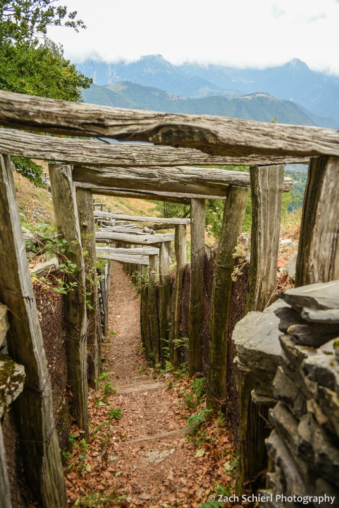
After five exciting days in the Julian Alps, it was time to head back to Ljubljana and return our rental car. En route, we detoured to a small outdoor museum on the border with Italy where you can walk through the remains of WWI trenches, bunkers, and tunnels on a high ridge overlooking the Soča River Valley. It was truly mind-boggling to imagine a massive war being fought in such rugged terrain, especially after seeing photos of the snowpack that accumulates in the winter.
Next up: a journey though three European capitals: Ljubljana, Zagreb, and Sarajevo!
