Wildflowers and Waterfalls of the Columbia River Gorge


Looking east along the Columbia River Gorge toward The Dalles on an alternately sunny & rainy March afternoon.
In the home stretch of its more than 1,000 mile-long journey from the Canadian Rockies to the Pacific Ocean, the Columbia River has carved a spectacular canyon that now forms the border between Oregon and Washington: the Columbia River Gorge. Nearly 100 miles in length, the Columbia River Gorge is one of the most unique landscapes in the Pacific Northwest, and home to some spectacular geology. Most of the gorge is carved into the Columbia River Basalts, layers upon layers of volcanic rock formed by vast lava flows that inundated most of central and eastern Washington about 16 million years ago. More recently, a series of large glacial outburst floods at the end of the last ice age broadened and re-shaped the gorge as they raged their way down the Columbia River to the Pacific Ocean, creating many of the landforms that we see today.
By the time the Columbia River enters the gorge, its elevation has already dropped to just 160 feet above sea level. The low elevation of the gorge makes it one of the warmest areas in the Pacific Northwest, and a prime destination for some early season camping. We recently spent three days in the Columbia River Gorge soaking up what passes for balmy weather this time of year around here.

An early spring view of the eastern Columbia River Gorge from Rowena Crest Overlook on the Oregon side of the gorge.

Motorcycle headlights illuminate the sweeping curves of the Historic Columbia River Highway just below Rowena Crest. The constellation of Canis Major sits just above the horizon. While the historic highway has been largely replaced by the much less charismatic I-84, large portions remain as backroads or hiking trails.
Two of the main attractions in the Columbia River Gorge are wildflowers and waterfalls. Even now, in mid-to-late March, the wildflower show was already in full swing, particularly in the drier, warmer, eastern reaches of the gorge:

Shooting stars (Dodecatheon sp.) are among the early blooming wildflowers in the eastern Columbia River Gorge. A yellow fritillary (Fritillaria pudica) lurks in the background.

Grass widows (Olsynium douglasii) are some of the earliest wildflowers to bloom in large numbers in the eastern Columbia River Gorge.

More grass widows…

Most grass widows are a vibrant pinkish purple color, but white petals are also found here and there.

Pungent desert parsley (Lomatium grayi) at Horsethief Butte.
One of the most remarkable sights in the Columbia River Gorge is experiencing the rapid change in environment as you drive through the gorge from east to west. The Dalles, located near the eastern end of the gorge, lies in the rain shadow of the Cascade Range and receives very little precipitation: just 14 inches annually. Here, the rocky slopes of the gorge are nearly devoid of any vegetation other than wildflowers and grasses. Just half an hour and a handful of freeway exists to the west, the average annual precipitation has increased to about 30 inches at Hood River, and ponderosa pine and Douglas fir cover the slopes. 20 more miles/minutes to the west, at Cascade Locks, annual precipitation rises to over 75 inches and the gorge is filled with the dense, shady, and mossy forests typically associated with the Pacific Northwest. In other words, you can travel from a true desert to a near-rainforest in less than an hour, while driving on a nearly flat interstate that hugs the shore of massive reservoirs created by dams along the lower Columbia River.

Large clusters of balsamroot (Balsamorhiza sp.) were beginning to flower in some of the drier, eastern parts of the Gorge, like these at Horsethief Butte.

An unknown species of fungus shares a decaying log with some moss. Scenes like this are common in the wetter, western half of the Columbia River Gorge.
The combination of dramatic terrain and copious precipitation at the western end of the Columbia River Gorge (particularly on the more mountainous Oregon side) combines to form some of the most spectacular waterfalls in the United States. As the aforementioned ice age floods flowed through the gorge on their way to the Pacific, they removed the lower ends of valleys belonging to the Columbia’s many tributary streams. Consequently, many of these tributaries enter the gorge several hundred feet above river level, terminating in spectacular plunges that carry their water into the Columbia River:

Latourell Falls plunges over a cliff of columnar basalt at the western end of the Columbia River Gorge, not far from Portland. This photo is a bit blurry; the trails to several of these waterfalls were busy, even on a somewhat chilly Tuesday in March, making it hard to set up a tripod for a steady shot.

Elowah Falls, Columbia River Gorge, Oregon. This shady alcove was heavily burned in the Eagle Creek Fire of 2017, but is already showing signs of re-growth.

Starvation Creek Falls, Columbia River Gorge, Oregon

Starvation Creek Falls, Columbia River Gorge, Oregon
Let’s be clear: with temperatures in the 40s and 50s and the nearly constant winds that blow through the gorge, it was no spring break in Florida, but after a long winter and with the Cascades still buried in snow for several more months, the greenery and signs of spring were a welcome sight. (Even though we did have our tent totally chewed up by an unknown animal…a first for us in many, many nights of camping throughout the west!)
Exploring the Eastern Slope


Late afternoon light in the William O. Douglas Wilderness, Wenatchee National Forest, Washington
After a summer of exploring the higher elevations of the Cascades in Washington and Oregon, our recent forays into the mountains have kept us closer to home. A highlight of fall in central Washington is the fall color display put on by the western and subalpine larch, a deciduous conifer that dots the drier slopes and sub-alpine areas of the eastern Cascades. We’ve taken two trips in the past few weeks to look for these gorgeous trees, but sadly arrived a bit early in both cases. Despite the poor timing, these trips took us to some great viewpoints and overlooks and allowed us to experience some amazing autumn sunrises and sunsets:

Sunset from Red Top, Wenatchee National Forest, Washington. Mt. Rainier is visible on the horizon at right.

Lingering wildfire smoke makes for a colorful sunset looking across the eastern foothills of the Cascades to Mt. Rainier.

Mt. Rainier rises above cliffs of basalt near Blewett Pass, Wenatchee National Forest, Washington.

A rainbow intersects the basalt canyons and plateaus of the eastern Cascade foothills, Wenatchee National Forest, Washington

Looking west toward the Cascade crest in the William O. Douglas Wilderness, Wenatchee National Forest, Washington

A peaceful campsite in the William O. Douglas Wilderness. Clouds sneaking over the Cascade crest to the west partially obscure the Milky Way, but not bright Jupiter.
Backpacking the Olympic Coast

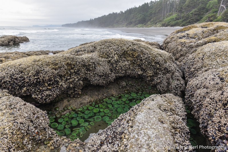
A tidepool filled with giant green anemones (Anthopleura xanthogrammica) along the coast of Washington in Olympic National Park.
Living in the desert of central Washington, it can be easy to forget that we live in a state with over 3,000 miles of coastline. While the high volcanic peaks of the Cascades are visible from our backyard (and thus remind us of their presence daily), the damp shores of the Pacific remain out of sight and out of mind most of the time.
Our most recent summer trip took us all the way to Washington’s western edge for a short backpacking trip along the coast in Olympic National Park. Coastal backpacking comes with a few unique challenges. For starters, predicting the weather along the coast is notoriously difficult, in part due to the relative lack of surface weather observations over the eastern Pacific and Gulf of Alaska, where most of our storm systems approach from. This fact ended up rearing its head on the final night of our trip.
Perhaps even more importantly, safe coastal backpacking requires that you know how to read a tide chart. The Washington coast experiences a fairly large tidal range, up to 10-12 feet during certain parts of the month. That’s enough to make vast sandy beaches completely disappear. A successful trip requires acute awareness of the timing and magnitude of the twice-daily high and low tides. The coast features many headlands (rocky outcroppings that jut out into the sea, often without any sort of “beach” whatsoever) that can only be traversed when the tide is below a certain level. Getting the timing wrong can (at best) result in having to sit on the beach for hours waiting for the tide to go out or (at worst) getting trapped in a dangerous situation as the tide rises and cuts off your escape route.
As this would be our first coastal backpacking trip, we obtained a permit for a fairly short and straightforward route beginning at Rialto Beach, heading north past the famous Hole-in-the-Wall, and eventually camping for two nights on the beach near the Chilean Memorial, the site of a shipwreck that killed 18 sailors all the way back in 1920. The terrain along this section of the coast was quite variable, ranging from long stretches of soft, sandy beach, to the slightly more annoying cobble and pebble beaches, to large boulder fields and headlands that were somewhat difficult to navigate with a heavy backpack:
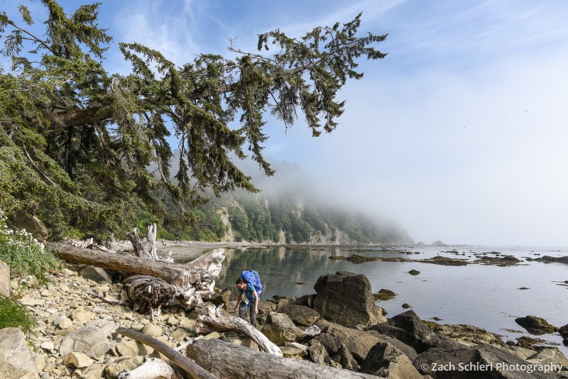
Picking our way along the rocky Olympic coast en route to our campsite at Chilean Memorial.

Tilted layers of sediment have been planed off by wave action near Hole-in-the-Wall, Olympic National Park, Washington.

Cape Johnson, Olympic National Park, Washington. With not much beach to speak of, this is a great example of a spot where being aware of the tide situation is essential!
After a little more than four miles of hiking, we arrived at the small, unnamed cove home to the Chilean Memorial and found a campsite just above the high-tide line among large pieces of driftwood. This sheltered cove made for a relatively quiet and peaceful camp, as the myriad rocks and sea stacks just offshore caught the brunt of the surf, limiting the amount of wave action reaching the beach. We enjoyed watching the landscape of the cove change over the next few days as the mist and tides repeatedly swallowed up and revealed the sea stacks and small rocky islands. We quickly discovered that the largest sea stack (pictured below) was connected to the mainland via a rocky isthmus at low tide, and ended up hiking out to it one evening to look back on our campsite.
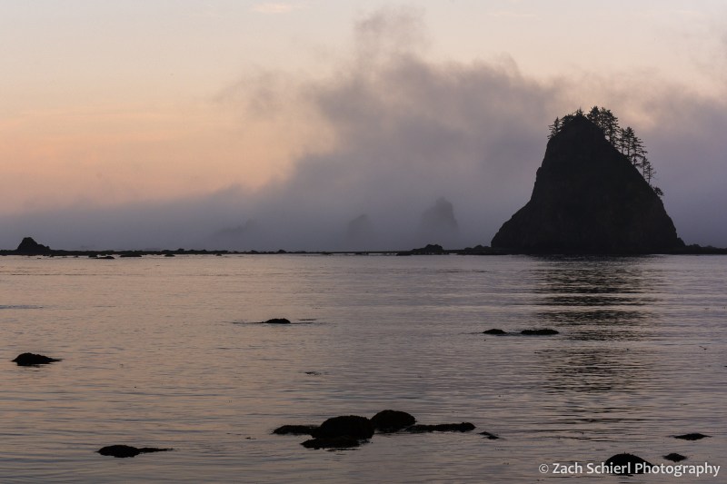
View out into the Pacific Ocean at sunset from our campsite on the Chilean Memorial beach in Olympic National Park, Washington

Looking back toward the Chilean Memorial beach and Cape Johnson from the base of the large sea stack in the previous photo.
While we had our fair share of clouds and mist, it did clear up enough on one evening to reveal the night sky. The moon was just past full, so the Milky Way was only barely visible, but it was still fun to see the southern stars rise and set over the Pacific:
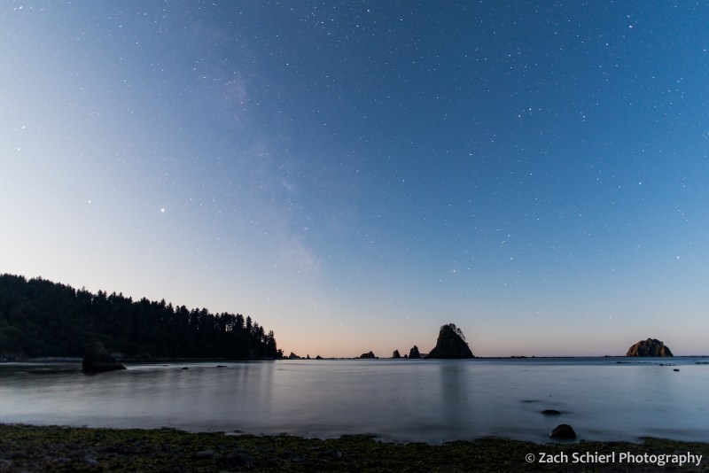
A faint hint of the Milky Way reveals itself despite the light cast by the rising moon (just behind the trees at left).

Enjoying a driftwood campfire on the beach.
Our trip came just a few days after the full moon, meaning that the low tides were some of the lowest of the month. These so-called “negative tides” are the best for exploring tide pools along the coast, as they reveal a greater variety of sea squishies:

Two giant green anemones in a tidepool in Olympic National Park, Washington.

A crowded tidepool containing multi-colored aggregating anemones (Anthopleura elegantissima) in Olympic National Park, Washington
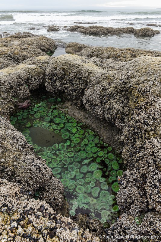
A tidepool filled with giant green anemones along the coast of Washington in Olympic National Park.
In addition to the living tidepool organisms, we also observed large quantities of dead jellyfish (at least three different species) washed up on the beaches, including several massive (~2 foot wide) lion’s mane jellies:

A deceased (?) lion’s mane jellyfish (Cyanea capillata) washed up on the beach in Olympic National Park, one of many, many such jellies we found on our trip.
For our third and final night, the original plan was to hike most of the way back to the car and camp along Rialto Beach near Hole-in-the-Wall. Prior to departure, the weather forecast for this night had called for a fairly robust storm coming in off the Pacific. With an ailing tent that has become somewhat more, shall we say, permeable than one would desire, we briefly debated whether to just call it quits to avoid the chance of getting soaked. Surprisingly, we were able to get enough cell service on the beach to check an updated weather forecast, which showed a drastically reduced chance of rain and little precipitation expected. Consequently, we decided to stick with the original plan and set up camp in the trees at the north end of Rialto Beach. Our decision to stay was quickly validated as we observed a number of whales spouting and breaching throughout the afternoon just offshore.

Our final campsite along Rialto Beach. From this vantage point, we saw a number of whales (likely humpbacks) spouting and breaching off-shore throughout the afternoon and evening.
12 hours later, at 3 AM, when I was emerging from the tent for the third time to re-secure our tarp and shelter in the face of driving rain, wind, and large, deafening waves crashing up against the bluff just a few feet from our tent, I wasn’t so sure. A great example of the fickle coastal weather I suppose, and a good character building experience as Calvin’s dad would say.
While intense, the storm was brief, and by morning the skies were clearing, making for a pleasant stroll down Rialto Beach back to the car. All in all, the trip was a refreshing change of scenery from our predominantly mountain-based adventures the rest of the summer!

Benign clouds greeted us in the wake of the storm for our short hike out to the car on the final morning.
