Europe Part 8: Out of the Albanian Alps (and back home)


Links to previous posts: Part 1, Part 2, Part 3, Part 4, Part 5, Part 6, Part 7
We arrived in Theth early in the afternoon after our hike across Valbona Pass. Like Valbona, Theth is strung out along several miles of a narrow mountain valley, with a dizzying array of peaks rising into the sky. One major difference was the vegetation, which in and around Theth was extremely lush and almost felt more tropical than mountainous. We really enjoyed our time in Theth; it felt more like an actual community and was definitely more happening than Valbona. Our lodging on this side of the mountains was located close to what you might call the town center. In addition to the slew of guesthouses, there was also a small market, a bar, a few restaurants, a few museums and historical sites, a church, and even a national park information center with some nice interpretive signs on the natural and cultural history of area (but still a perplexing lack of hiking information or maps!)
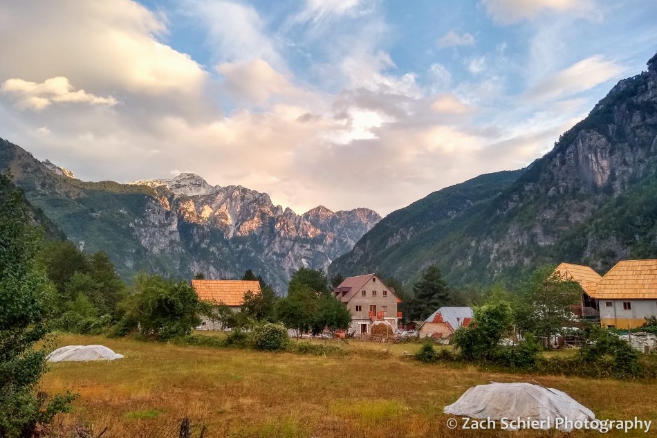
After our hike over from Valbona, we spent the rest of the afternoon relaxing and exploring town a bit, while waiting out a few more heavy downpours. We had rain and thunderstorms pretty much every afternoon in the Albanian Alps, a contrast to the sunny and hot weather we experienced everywhere else on the trip. Unlike our guesthouse in Valbona, the one we stayed at in Theth had a small restaurant that served dinner. We ended up eating there both nights because the food was so good; definitely our best meals in Albania! One great thing about Albanian food was the vegetables: fresh, delicious vegetables were served at every meal, unlike in Bosnia where they were often nowhere to be found. We also got to sample raki, a traditional Albanian liquor made with plums. It tasted pretty much like straight liquor or vodka to me…not my favorite.
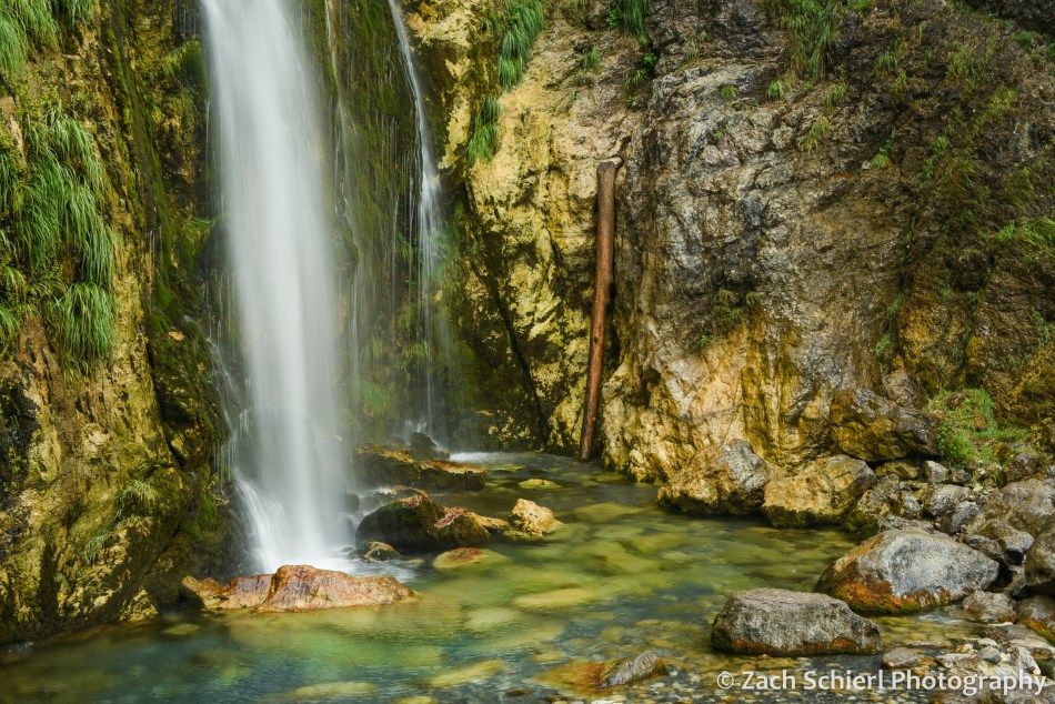
The classic hike in the Theth area is an all day, 12+ mile hike to the “Blue Eye” waterfall. At this point in the trip, we were starting to run out of gas so we decided to forgo the Blue Eye and set out on a somewhat more relaxing itinerary of visiting the (closer) Grunas Canyon and Grunas Waterfall, and then some of the attractions in Theth itself. The first part of the hike took us along the roaring Theth River and over a rickety little bridge with a concerning number of planks missing. Soon we arrived at the Grunas Canyon, a very deep and narrow slit carved into the limestone by the river. On the way back to town we detoured to the Grunas Waterfall, which was about 100 feet high and plunged into a very cold-looking pool of water with lots of moss, ferns, and other green vegetation growing around it. The waterfall was a busy spot despite the somewhat treacherous final approach and the intermittent rain. Several large groups of people came and went, the most people we ever saw in one place in all of the Albanian Alps!

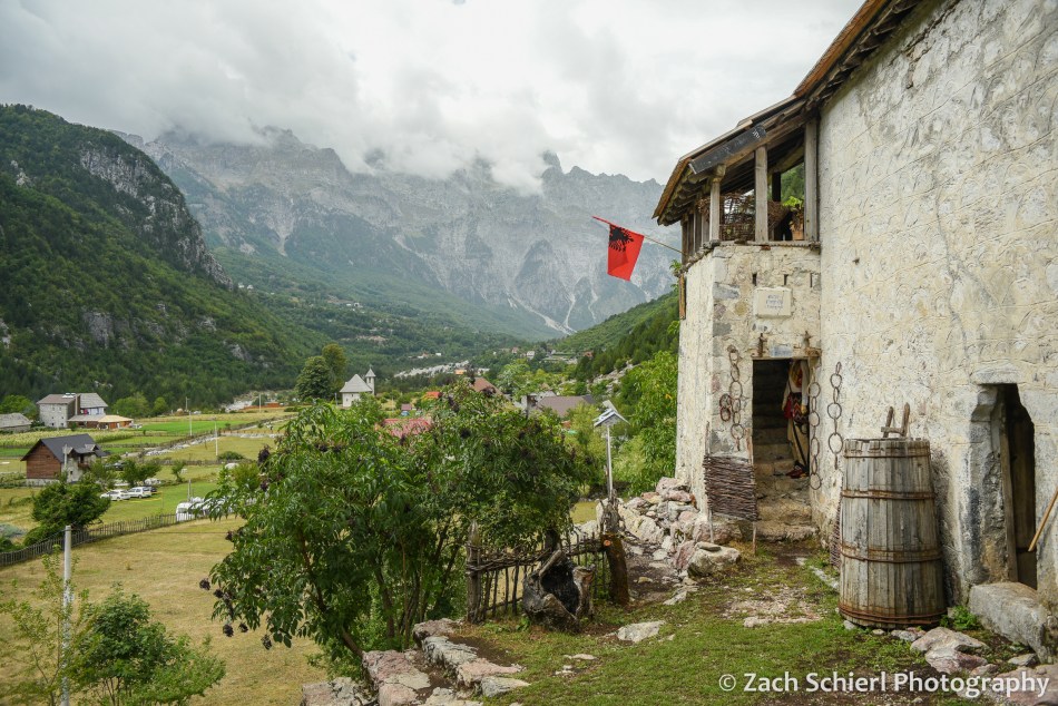
Once back in Theth, we followed a little trail across the fields and farms to the local history museum, located in a 330 year old house built on top of a gigantic rock. The museum caretaker lives next door and spotted us approaching. She ended up giving us a private tour of the museum, pantomiming the use of the many of the objects within to overcome the language barrier. If we understood correctly, it was actually the house that she had grown up in, though not 100% sure on that. Before we left, she insisted that we take home a bunch of fruit from the trees in the yard, so we ended up with a whole bag of very delicious plums of different sizes and colors. We stopped at the little Catholic church which, while quite new (1892) by European standards, is very unique on the outside and was extremely photogenic against the backdrop of the mountains.


The following morning we boarded a minivan to head back to Shkodër and then on to the Albanian capital, Tirana. The drive out of Theth was pretty spectacular. A very narrow and steep road switchbacks up the valley wall, with incredible views out across the mountains. This was actually still a dirt road until just last year. It is only about 45 miles from Theth to Shkodër, but it took close to three hours even with an entirely paved surface. The road is just a single lane until a few miles outside Shkodër, and there was enough traffic that we spent a lot of time pulling over to let other vehicles pass. We also discovered that public transportation in Albania involves making numerous unexplained stops on the side of the road. All part of the adventure!
In Shkodër we transferred to a bus that was headed for Tirana. This was another slow ride, as the two-lane highway between two cities was packed with traffic. We were a bit surprised when the bus suddenly and unexpectedly dropped everyone off on the outskirts of Tirana. Apparently the intercity buses are not allowed into the city center (where we were staying), which we were not aware of. We considered just walking, but it would have been several miles with all our luggage and would have required crossing a major freeway. We had also not eaten much or used the bathroom for many hours, so eventually we managed to procure a taxi to take us the last few miles into town.
After checking in to our hotel we set out to find dinner and explore Tirana. We ate at a restaurant in the “Tirana Castle,” which used to be a castle but now is an upscale shopping and dining corridor. We walked around the city a bit en route back to our room, passing through the massive Skanderbeg Square in the center of town.

Tirana seemed like a very nice city, but sadly this was the last I would see of it. I spent the next 24 hours in bed with food poisoning. Fortunately, it couldn’t have happened on a better day. We had scheduled a full day in Tirana before our departure as a “cushion day,” in case we encountered any travel delays in our journey up until this point. We hadn’t, so while I missed out on Tirana sightseeing, it didn’t affect our travel plans beyond that. Fortunately I was feeling somewhat better the following morning since we had to be at the Tirana airport by 3:30 am to begin our journey home. Leg 1 would take us across the Adriatic Sea from Tirana to Rome, where we had about a day and a half before our flight back to Canada and the U.S. In a twist of irony, we had added our long layover in Rome in part because, when we visited Italy in 2018, our day in Rome got partially torpedoed by…you guessed it…food poisoning! I had been looking forward to exploring Rome while fully healthy, but alas that was not to be.
Between the residual effects of food positioning, the fatigue of a month of travel setting in, only a few hours of sleep due to the early flight, and temps soaring to almost 100 degrees, we weren’t entirely sure what to do with ourselves in Rome. We ended up taking the Metro and then a bus to the outskirts of town to see the old Appian Way and the Catacombs of San Sebastiano. The catacombs are huge networks of underground tunnels where the Christians of Ancient Rome buried their dead. Very interesting, and a little creepy…pictures not permitted. Honestly though, what I remember best is that it was mercifully ~40 degrees cooler underground than on the surface. I never thought I’d be so grateful to spend half an hour in a underground crypt! The catacombs were located right along the Appian Way, one of the world’s first paved highways built over 2000 years ago to connect Rome to important points southward in Italy. The original basalt paving blocks are still intact and the road is still used as…a road! You can drive your car right down it. Fortunately this spot was far enough outside the city center that there wasn’t much traffic, so we walked down the Appian Way for a short distance but didn’t make it very far since it was so damn hot.
After a short nap back at the hotel, I was feeling mostly back to normal so we took the Metro again, this time to the Vatican City area where I ate my first solid food in almost 48 hours. After dinner we went on a whirlwind walking tour of Roman sights: The Vatican and St. Peter’s Square, the Tiber River, Plaza Navona, Trevi Fountain, the Pantheon, and the Spanish Steps. We had visited some of these sights in 2018 in our food poisoning induced stupor, so it was cool to see them again at a different time of year and in marginally better health.


Our flight back to Canada wasn’t scheduled to leave until 2:00 pm the following day, but we woke up to an email that it had already been delayed until 4:00 pm, so we ended up with another half day in Rome. Suffice to say that at this point, we were both feeling pretty tired and done with sightseeing. We walked around the Baths of Diocletian, the largest public baths in the Roman empire at one point (and right down the street from our hotel) for a few hours before heading to the airport. This turned out to be more challenging than expected, as the train line that connects central Rome to the international airport (about 30 minutes away) had been shut down due to a fire on the tracks. We ended up fighting for space on one of the handful of shuttle busses that travels between the central train station and the airport, getting there quite a bit later than planned. Fortunately the security line was basically nonexistent so we made it to the gate with plenty of time to spare.
Our flight to Calgary was uneventful. (Props to Westjet for getting us to and from Europe without issue during a summer of crazy travel chaos!) We got some nice views of the ice sheets and glaciers of Greenland and Baffin Island. Entering Canada was, surprisingly, a breeze. We had to fill out a bunch of COVID-related paperwork in advance to enter the country, but were never asked for any of it nor did we have to show our vaccine cards upon arrival. The biggest drama came when our cab driver from the airport to our hotel in Calgary almost ran me over as I was putting the bags in the car. We had a ~18 hour layover in Calgary, but were so tired and jet lagged that we barely left our hotel. The next morning was a short flight back to Seattle, where we strolled off the plane and into the terminal…through the same gate we had begun our journey through one month earlier!
It’s so hard to summarize a trip like this, especially in blog form, so I’m not really going to try apart from a few closing thoughts. For context, the distance between our starting point, Ljubljana, and ending point, Tirana, is roughly the same as the distance from Seattle to Klamath Falls, Oregon, so this trip really represented a pretty small corner of the world, one which we feel very fortunate to have had the opportunity to explore for a month. Looking back almost four months later, some of the experiences that stand out for me are: learning about the distinct yet intertwined culture and history of five different countries from a series of wonderful guides and hosts. Trying a huge array of amazing foods (had we not done an insane amount of walking, I think we would have come back somewhat heavier!) The ease and comfort of getting around via public transportation in Europe (Mostar—>Dubrovnik bus excluded.) And, of course, photographing the cities and landscapes of the Balkans was a lot of fun. In the end, we got through a month-long trip abroad and the worst thing that happened was my bout of food poisoning…pretty good I think!
Thanks for following along. Next it will be back to our regularly scheduled programming: photos of the Pacific Northwest!

Wildflowers and Waterfalls of the Columbia River Gorge


Looking east along the Columbia River Gorge toward The Dalles on an alternately sunny & rainy March afternoon.
In the home stretch of its more than 1,000 mile-long journey from the Canadian Rockies to the Pacific Ocean, the Columbia River has carved a spectacular canyon that now forms the border between Oregon and Washington: the Columbia River Gorge. Nearly 100 miles in length, the Columbia River Gorge is one of the most unique landscapes in the Pacific Northwest, and home to some spectacular geology. Most of the gorge is carved into the Columbia River Basalts, layers upon layers of volcanic rock formed by vast lava flows that inundated most of central and eastern Washington about 16 million years ago. More recently, a series of large glacial outburst floods at the end of the last ice age broadened and re-shaped the gorge as they raged their way down the Columbia River to the Pacific Ocean, creating many of the landforms that we see today.
By the time the Columbia River enters the gorge, its elevation has already dropped to just 160 feet above sea level. The low elevation of the gorge makes it one of the warmest areas in the Pacific Northwest, and a prime destination for some early season camping. We recently spent three days in the Columbia River Gorge soaking up what passes for balmy weather this time of year around here.

An early spring view of the eastern Columbia River Gorge from Rowena Crest Overlook on the Oregon side of the gorge.
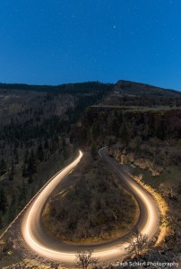
Motorcycle headlights illuminate the sweeping curves of the Historic Columbia River Highway just below Rowena Crest. The constellation of Canis Major sits just above the horizon. While the historic highway has been largely replaced by the much less charismatic I-84, large portions remain as backroads or hiking trails.
Two of the main attractions in the Columbia River Gorge are wildflowers and waterfalls. Even now, in mid-to-late March, the wildflower show was already in full swing, particularly in the drier, warmer, eastern reaches of the gorge:

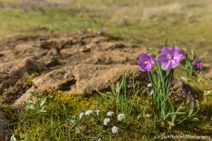
Shooting stars (Dodecatheon sp.) are among the early blooming wildflowers in the eastern Columbia River Gorge. A yellow fritillary (Fritillaria pudica) lurks in the background.
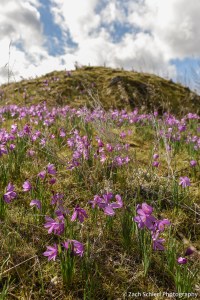
Grass widows (Olsynium douglasii) are some of the earliest wildflowers to bloom in large numbers in the eastern Columbia River Gorge.
More grass widows…

Most grass widows are a vibrant pinkish purple color, but white petals are also found here and there.
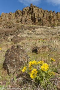
Pungent desert parsley (Lomatium grayi) at Horsethief Butte.
One of the most remarkable sights in the Columbia River Gorge is experiencing the rapid change in environment as you drive through the gorge from east to west. The Dalles, located near the eastern end of the gorge, lies in the rain shadow of the Cascade Range and receives very little precipitation: just 14 inches annually. Here, the rocky slopes of the gorge are nearly devoid of any vegetation other than wildflowers and grasses. Just half an hour and a handful of freeway exists to the west, the average annual precipitation has increased to about 30 inches at Hood River, and ponderosa pine and Douglas fir cover the slopes. 20 more miles/minutes to the west, at Cascade Locks, annual precipitation rises to over 75 inches and the gorge is filled with the dense, shady, and mossy forests typically associated with the Pacific Northwest. In other words, you can travel from a true desert to a near-rainforest in less than an hour, while driving on a nearly flat interstate that hugs the shore of massive reservoirs created by dams along the lower Columbia River.
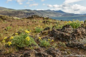
Large clusters of balsamroot (Balsamorhiza sp.) were beginning to flower in some of the drier, eastern parts of the Gorge, like these at Horsethief Butte.
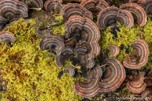
An unknown species of fungus shares a decaying log with some moss. Scenes like this are common in the wetter, western half of the Columbia River Gorge.
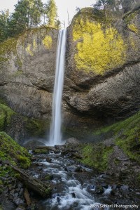
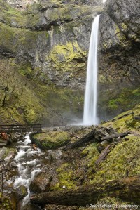
The combination of dramatic terrain and copious precipitation at the western end of the Columbia River Gorge (particularly on the more mountainous Oregon side) combines to form some of the most spectacular waterfalls in the United States. As the aforementioned ice age floods flowed through the gorge on their way to the Pacific, they removed the lower ends of valleys belonging to the Columbia’s many tributary streams. Consequently, many of these tributaries enter the gorge several hundred feet above river level, terminating in spectacular plunges that carry their water into the Columbia River:
Latourell Falls plunges over a cliff of columnar basalt at the western end of the Columbia River Gorge, not far from Portland. This photo is a bit blurry; the trails to several of these waterfalls were busy, even on a somewhat chilly Tuesday in March, making it hard to set up a tripod for a steady shot.
Elowah Falls, Columbia River Gorge, Oregon. This shady alcove was heavily burned in the Eagle Creek Fire of 2017, but is already showing signs of re-growth.

Starvation Creek Falls, Columbia River Gorge, Oregon

Starvation Creek Falls, Columbia River Gorge, Oregon
Let’s be clear: with temperatures in the 40s and 50s and the nearly constant winds that blow through the gorge, it was no spring break in Florida, but after a long winter and with the Cascades still buried in snow for several more months, the greenery and signs of spring were a welcome sight. (Even though we did have our tent totally chewed up by an unknown animal…a first for us in many, many nights of camping throughout the west!)
Wonderful Waters of the Escalante


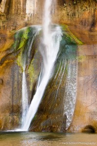
Lower Calf Creek Falls sits on a tributary of the Escalante River. It’s not everyday you find a waterfall this large in the desert!
The Escalante River in south central Utah was supposedly the last river in the continental United States to be “discovered” and mapped. You don’t have to spend too much time with it to see why. First of all, it’s not large. “River” is a bit of an overstatement for most of the year, when it is easily forded on foot. Only during torrential summer monsoon storms does it resemble anything that the rest of the world would call a river. Secondly, even the most easily accessible stretches of its ~90 mile course take some time to get to. The Escalante is crossed by a grand total of one paved highway, a remote stretch of Utah Highway 12 that is among the most scenic drives in the west.
The lower reaches of the Escalante’s sinuous canyon pose even more of a challenge, reached only by boat on Lake Powell, or via a combination of hellish dirt roads and long hikes, something we undertook on a backpacking trip a few years back when we entered the Escalante via one of its tributaries, Coyote Gulch.
Upper portions of the canyon are far more accessible, if not as imposing, requiring only an occasional wade across the river to see sights such as the Escalante Natural Bridge:
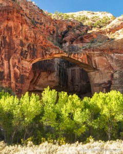
Escalante Natural Bridge, more than 100 feet in length, blends in well with its surroundings.
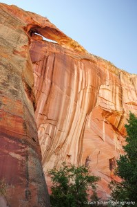
Streaks of light mud and dark desert varnish coat towering cliffs of Navajo Sandstone in the upper Escalante River canyon.

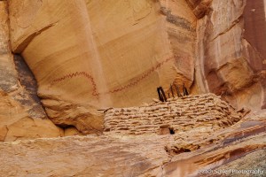
A cliff dwelling and pictographs in a high alcove along the Escalante River. This alcove looked thoroughly inaccessible from below, but the relatively modern graffiti visible through the telephoto lens sadly indicated otherwise.
One of the most significant tributaries of the upper Escalante River is Calf Creek, best known for a pair of waterfalls that are refreshingly out of place in a place not generally known for its aqueous wonders. Lower Calf Creek Falls, the larger of the two cascades, is reached via a ~3 mile hike along a broad canyon carved by the creek:

Enjoying a peaceful and relatively uncrowded visit to Lower Calf Creek Falls.

Desert varnish is a common sight throughout the southwest, but the palette of colors on the cliffs flanking Calf Creek seemed especially varied.
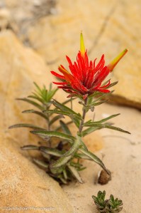
One of the few wildflowers left standing in late September: a single desert paintbrush (Castilleja chromosa)
A few miles north, reaching the smaller Upper Calf Creek falls requires a short but steep scramble down a slickrock slope into the depths of the canyon:
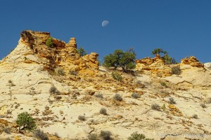
The 3rd quarter moon sets over sandstone rock formations in the Upper Calf Creek drainage.
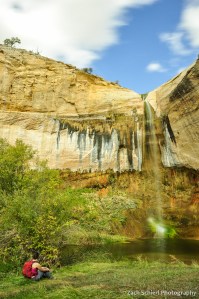
Enjoying the solitude at Upper Calf Creek Falls.
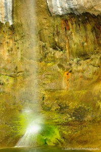
Clumps and mats of moss and other plants coat the cliffs beneath Upper Calf Creek Falls.
Surrounded by some of the least developed land in the continental United States, the night sky from the Escalante canyons is a prime attraction as well!

The summer Milky Way sets over the southern horizon near Escalante, Utah. No light pollution in sight!
