Upcoming Exhibition and Geology Talk


Every year, Cowiche Canyon Conservancy (an amazing non-profit land trust here in Yakima) partners with the Boxx Gallery in Tieton, WA to host “Images of the Shrub-Steppe“, a juried art exhibit featuring work inspired by the threatened sagebrush-steppe ecosystem of the Yakima Valley.
I’ve thoroughly enjoyed photographing this unique and wide-open landscape (especially during spring wildflower season!) since we moved to Yakima in 2019, and I was honored to have two of my images selected for the exhibition this year. The show will be open Friday-Sunday throughout September.
In addition, on the closing Saturday of the show (Sept 28), I’ll be giving a talk on the geology of the shrub-steppe from 1-2 pm at the Boxx Gallery. The focus will be on the two main lava flows that underlie the valley: the Columbia River Basalts and the Tieton Andesite, which form the backdrop for some of my favorite images from the Yakima area, such as the one above.
Full hours and details can be found in the flyer below:

A Total Eclipse Travelogue

Question: What’s the first thing you do after witnessing a total solar eclipse?
Answer: Google when and where the next one is.
That’s certainly been true for me. Immediately after my wife and I observed the 2017 total solar eclipse from a remote patch of BLM land outside of Riverton, Wyoming, we knew we needed to make plans to see another. We discussed going to Argentina or Chile in 2019 but ended up moving from Utah to Washington that summer. Totality again passed over Argentina and Chile in December 2020, but COVID scuttled plans for that one before they ever got off the ground. The total eclipse of December 2021 was only visible from Antarctica…a bit outside our price range. April 2023 offered a brief view of totality over Indonesia, but April is a hard time for a pair of school employees to take extended time off work.
From the beginning, the solar eclipse of April 8, 2024 was always the most realistic option, with its wide path of totality stretching across North America from Mexico to Newfoundland. As soon as plane tickets went on sale about a year in advance, we booked a pair of tickets to Torreón, Mexico, the location most likely to be clear in early April based on historical climate records.
In Fall 2023, we learned that my wife was pregnant. Extremely exciting, but not conducive to an international eclipse journey a month before our due date! Mexico was not to be. With the blessing of my lovely wife, I used a bunch of points on Southwest Airlines (that we had received as an “apology” for their meltdown the prior winter) to book a relatively last minute plane ticket to Austin, Texas. Thanks to an astronomy friend with a relative who lived in the Austin area (Hi Becky!), I had a place to camp…a critical part of this plan given that the few remaining hotels were going for upwards of $500/night by this time. With wife and baby in good shape, and a rental car my only major expense, I headed to Austin a few days before the eclipse for a shot at seeing my second total solar eclipse.
After a rocky start picking up my rental car (WARNING: Hertz will sell you a reservation at a pickup time during which they are not actually open!), I enjoyed two days of hiking and exploring on the outskirts of Austin, all the while keeping an eye on the weather forecast for eclipse day. Wildflower season was in full swing, and the combination of lush greenery plus desert plants was a delight to photograph:


Statistically speaking, the skies were much more likely to be cloudy in Austin vs. Torreón. April is around when severe weather season typically picks up on the southern plains, and the weather forecasts for eclipse day had looked grim a whole week in advance. I reminded myself that this had been the case for our trip to see the October 2023 annular eclipse in Oregon, and we ended up getting a hole in the clouds at exactly the right time. Hope springs eternal!
I awoke on April 8 to the worst weather conditions imaginable for seeing a solar eclipse: a thick layer of opaque low clouds and fog, plus a light drizzle. Forecasts showed the low clouds breaking up somewhat by eclipse time, especially to north of Austin. However, the weather forecast for north Texas also included a solid chance of severe weather later in the afternoon. The memory of sitting in gridlock “eclipse traffic” for hours following the 2017 eclipse made me wary of getting stuck on the highway back to Austin with a storm potentially bearing large hail or a tornado on the way. In the interest of personal safety, I decided to head west instead, where the risk of severe storms was lower but the chance of clouds higher. This would also take me closer to the eclipse centerline and add potentially precious seconds or minutes to totality…key if banking on a view through tiny gaps in the clouds.
After weeks of studying highway maps, the eclipse track, and weather forecasts, I ended up pulling into the town of Dripping Springs, about 40 minutes west of Austin, at 11:30 am, two hours prior to totality. Dripping Springs was holding a block party to celebrate the eclipse, which I figured would provide some entertainment and at least allow me to commiserate with others over a beer in the event that we got skunked. Dripping Springs is also reasonably well known in astronomy circles as one of the first International Dark Sky Cities. (Flagstaff, AZ, my hometown, was the first.) I’m not a superstitious person, but I’d be lying if I said I wasn’t hoping for a little cosmic poetry!
By the time the partial eclipse began about 12:15 pm, sky conditions had improved markedly from earlier in the morning. While it was not “clear” by any stretch, the low clouds had broken enough to offer intermittent views of the Sun through an upper level layer of cirrostratus. I got my camera and solar filter set up, and started taking images of the partial phases. There was a large sunspot near the center of the Sun’s disk that disappeared behind the Moon about an hour in:


Up to this time, I had my camera set up right next to my vehicle, and was keeping a close eye on satellite imagery in case there were larger areas of clearing that might be reached by a last-minutes dash down the highways of the Texas Hill Country. About 30 minutes prior to totality, cell service went down for about 20 minutes, so that was the end of the weather watching. Dripping Springs it would be. I took my camera over to a small city park where many others were gathering to watch totality, sat down, and hoped for the best. About 15 minute before the big event, the low clouds returned, darkening the sky for the wrong reason and completely obscuring the Sun. Things were looking bleak.
It has long been known that deep eclipses have an impact on the weather. Perhaps not surprisingly, blocking out a big chunk of our atmosphere’s ultimate heat source often has a tangible influence on surface heating, convection, and cloud formation. Perhaps the eclipse itself was why the low clouds almost totally evaporated about 5 minutes before totality (though a thick layer of high clouds remained), creating the largest and most prolonged break we saw all day. With just a few minutes to go, I realized we were actually going to see this thing.
In 2017, with weather not a factor, the build up to totality was gradual, with the shadows and light seemingly changing by the minute. This time, with direct sunlight obscured by clouds until just minutes before totality, the bizarre, otherworldly light that accompanies the final moments of the partial eclipse seemed to hit all at once. The excitement in the crowd was palpable as the final rays of sunlight winked out. Totality was upon us!
I had been so fixated on the weather forecast over the preceding days and weeks that I hadn’t really considered how a total eclipse near solar maximum might look different than one near solar minimum (as in 2017). The difference was immediately apparent, as several large, red, solar prominences burst into naked-eye view as soon as totality began. These glowing loops of hydrogen gas are always present, though there are more of them around solar maximum. Typically, they are only visible with a $1000+ hydrogen-alpha solar telescope because they are otherwise washed out by the Sun’s immense brightness. With the moon taking care of that, larger prominences are easily visible to the naked eye. An especially large loop, likely 4-5x the size of Earth was visible on the lower limb throughout totality. Visibility of the Sun’s outer atmosphere, known as the corona, typically a highlight of a total eclipse, was mostly masked by the high cloud layer. I was able to tease it out a bit in the photos, but to the naked eye it wasn’t prominent:
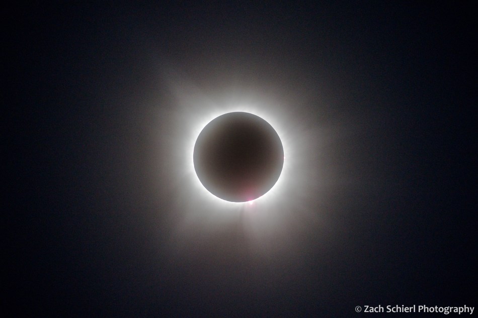
Speaking of photos, while this was my second time seeing a total solar eclipse, it was my first time photographing one. The advice I received prior to the 2017 eclipse was simply to sit back and enjoy the experience, rather than fidget with a camera. As hard as that was for an astrophotographer, I’m glad I took that advice and would recommend the same to anyone experiencing their first total eclipse. (Though I did cheat a little and set up my camera to automatically take a wide-field time-lapse sequence before, during, and after totality.) This time around though, I was determined to capture some images and thanks to extensive planning and practice beforehand, I didn’t feel like it detracted from my ability to simultaneously enjoy the eclipse.
Totality lasted for about three minutes, and to my surprise it felt longer than expected. My proximity to a highway and civilization meant I didn’t really experience any changes in sound, animal behavior, or temperature, though I was so transfixed by the visual scene that in hindsight I don’t think I really thought to look for any of these things. After some initial whooping and hollering, the crowd was mostly quiet, enjoying a spectacle that the contiguous United States won’t experience again until 2044. After observing the 2017 total solar eclipse from a sagebrush sea in Wyoming, it was a novel and enjoyable experience to witness the utter joy and amazement it brings alongside so many others. It indescribably surreal to see a gigantic black hole in the sky where the Sun should be. It is impossible for any picture to truly capture the experience of being in the path of totality. If you ever get the chance to see a total solar eclipse, TAKE IT! Make it happen. Whatever you need to do. You’ll thank yourself.
At the end of totality, I was fortunate enough to capture an image of the elusive “diamond ring” effect: the first rays of sunlight bursting back into view from around the edge of the new moon. A student asked me yesterday what my favorite photo I’ve ever taken is. This might be it:

With most serious eclipse chasers having scattered to other states with better weather prognoses, I was one of just a few people in the crowd with a large camera or telescope. My behemoth of a telephoto lens attracted some attention as folks were filing out, so I ended up spending the hour after totality doing lots of impromptu astronomy education, sharing some of my preliminary images, and chatting with folks about what we had just witnessed.
While the eclipse was technically still in progress at this point, I didn’t see much of it. 10 minutes after totality, the low clouds re-formed, and we barely saw the Sun again the rest of the afternoon. Had totality been 15 minutes later we wouldn’t have much at all. Unless, that is, that totality itself was the cause of the clearing. While this is certainly possible, I’m skeptical given that I spoke with several other people in the following hours and days who had been as close as a few miles down the road from Dripping Springs and still got clouded out. I think we got lucky. That means I’ve been lucky two eclipses in a row, so if you are looking for a experienced astronomy educator to speak at your next eclipse event in Spain, Egypt, or Australia, drop me a line!
Exploring the Mt. Adams Wilderness


Mt. Adams is the largest (by volume) and second highest volcano in the Cascade Range of Washington. Often overshadowed by its neighbors, Mt. Rainier, Mt. St. Helens, and Mt. Hood, we’ve taken a liking to Adams in part because its trails tend to be relatively deserted and in part because we have a fantastic view of the mountain’s east face from our neighborhood in the Yakima Valley. Recently we had the chance to complete a short backpacking trip on the north flank of the mountain which allowed us vantage points that far surpass anything we’ve seen on previous day hikes.
Our hike began and ended at a trailhead (Killen Creek) that is, as the crow flies, just 57 miles from our front door, but takes more than three hours to reach by car, giving some sense as to the relative remoteness of this area. Most of our ~20 mile loop was within the Mt. Adams Wilderness, a 48,000 acre wilderness area designated in 1964 with the original passage of the Wilderness Act.

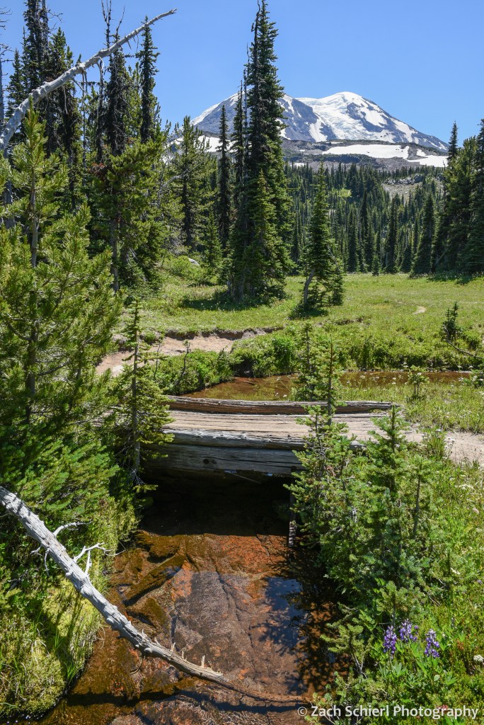
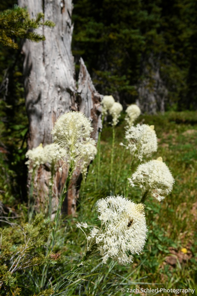
On our first night, we camped at just under 7,000 feet on the north flank of the mountain in one of the most spectacular alpine meadows I’ve seen. No matter which way I turned, the views were extraordinary. To our south, the crumbling volcanic edifice of Mt. Adams loomed large, with the Adams Glacier descending in a stunning icefall from the summit plateau. To the north, broad expanses of dense evergreen forest stretched off into the distance, leading the eye to the massive Mt. Rainier and the rugged skyline of the Goat Rocks on the horizon. To the west, the truncated cone of Mt. St. Helens was backlit by the setting sun. Several lingering snowfields surrounded our campsite, providing a nice source of clear, cold water. A variety of diminutive alpine wildflowers were in full bloom, and the low rumble of rock and ice fall high on the mountain occasionally punctuated the silence, with clouds of dust the only clue as to their location. While this location is reachable by a long day hike, spending the night and being able to explore and photograph in the late afternoon and evening light is one of my favorite things about backpacking!


On Day 2, we descended to the Pacific Crest Trail before working our way around to the northeast side of Mt. Adams, passing through a series of wildflower-filled meadows and crossing several inviting streams cascading down from melting snowfields and glaciers higher on the mountain. These meadows also hosted a robust population of mosquitos and other biting insects….not unexpected for the Cascades in July, but an annoyance nonetheless, especially for an Arizona-born desert rat like me!

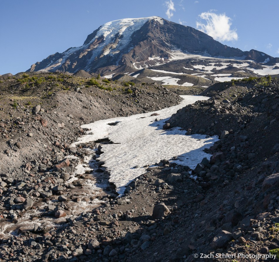
We had shared the trail with quite a few other hikers and backpackers on Day 1, but saw only a few other people from this point forward. Camp on night two was in a small clump of trees on the edge of a relatively recent lava flow. In contrast to the verdant alpine meadows of night one, this landscape was much more rugged, barren, and stark. After setting up our tent, we proceeded up the trail (with much lighter packs!) to find a spot for dinner. We quickly arrived at a stream crossing that we didn’t feel comfortable fording, so we left the trail behind and proceeded to pick our way up the rubbly bank until we arrived at a small knob with a spectacular view of the glaciers on Mt. Adams’ northeast face (Lava, Lyman, and Wilson). Here we enjoyed a delicious meal of instant mashed potatoes mixed with green chiles and an entire bag of bacon bits while listening to the roar of the creek.
Our best wildlife sighting of the trip actually occurred on the drive to the trailhead, when we happened upon a young barred owl sitting in the road. As we approached it flew into a nearby tree where it watched us warily for a few minutes before fleeing deeper into the forest:

Aside from this, we saw surprisingly little wildlife on this trip (unless you count mosquitos): only a few birds, chipmunks, squirrels, and a single marmot and mountain goat in the far distance from our first camp.
From our second camp, we were in a great position to catch sunrise on the final morning of our trip. There aren’t many things I’ll get up at 5:15 am for, but a Mt. Adams sunrise is definitely one of them!

After packing up, we hiked the eight downhill miles back to our car and drove back into the 100 degree blast furnace that is the Yakima Valley in late-July. We are thankful to have beautiful places like Mt. Adams so close to escape the heat this time of year!
