Throwback Thursday: Glacier Peak


Glacier Peak…the top of it at least. This was about the most we saw of it on our three-day trip.
While we wait for the snows to melt once again, time for another flashback to 2020. I realize that phrase likely strikes fear in the hearts of most, so feel free to pretend these photos are from some other year. While it was a rough year in many ways, the wilderness was just as spectacular as ever!
For a while last summer, our goal was to camp in the shadow of every active Cascade Range stratovolcano in Washington and Oregon. We ended up getting to 8/10, but late season plans for Mt. Baker and Mt. Jefferson ended up being derailed by fires, weather, or both. In total we camped 28 nights and hiked/backpacked over 250 miles in our COVID-safe exploration of the Cascades last summer. To minimize contact with others (and to save money), we eschewed developed campgrounds in favor of dispersed camping. Aside from backpacking permits, we paid for accommodations just once the entire summer, at a five-site Forest Service “campground” on the north side of Mt. Hood that we ended up having all to ourselves for the night.
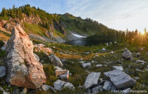
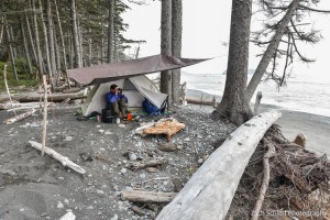
One of our most memorable excursions was a quick two-night backpacking trip to the Glacier Peak and Henry Jackson Wilderness areas in north-central Washington.
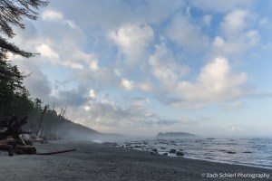
Early morning light at a campsite along the Pacific Crest Trail in the Henry Jackson Wilderness Area of central Washington
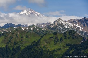
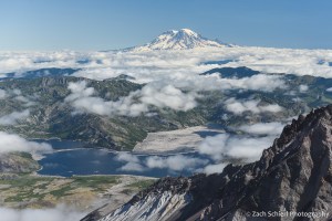
Of all the active volcanoes in the Cascade Range, Glacier Peak is by far the most difficult to glimpse up close. Tucked away in the north Cascades, reaching the vicinity of the Glacier Peak edifice requires a hike of at least 10-12 miles, making a backpacking trip really the only way to truly experience the mountain. For us, it was a ~35 mile, 3-day, 2-night trip beginning from the valley of the Little Wenatchee River. While were able to get quite close to the mountain, this was (amazingly) the only trip of the summer where the weather didn’t really cooperate with our desire to see the mountain in whose shadow we were camping. We got a handful of summit glimpses through breaks in the clouds, but Glacier Peak was obscured for the majority of our trip.

Tantalizing glimpses of Glacier Peak through the low clouds.
A fleeting view of the glacier-clad (not surprisingly) summit of Glacier Peak.
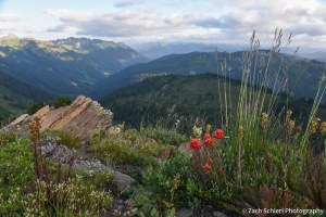
Looking down the Little Wenatchee River valley with some late season paintbrush providing a splash of color.
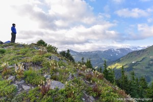
The view from Kodak Peak in the Glacier Peak Wilderness. Glacier peak is behind those clouds somewhere!

A marmot enjoys the view from Kodak Peak.
Despite the lack of peak views, the rugged, high altitude terrain was stunning and while we were a little too late for peak wildflower season, there were still lots of blooms covering the slopes:

Tiger lilies (Lilium columbianum) in the Glacier Peak Wilderness, Washington
The most memorable elements of the trip came on Day 3. After a COLD morning and a close brush with hypothermia, we decided (based largely on consulting with other hikers) to take a slightly longer, but less steep, route back to the car. Our ascent two days earlier had been short, steep, and rocky, and we weren’t thrilled about the idea of descending the same trail with heavy packs. Plus an alternate trail back to the car would result in a loop and who doesn’t love a good loop? According to maps and other hikers, our descent would be about 8-9 miles, instead of the six miles we had come up. Despite the modest mileage, it ended up being quite the slog. I’ve done enough hiking and backpacking that I normally feel pretty confident estimating mileage, and that descent sure felt like a LOT more than 9 miles. The trail was in decent shape, save for crossing a series of avalanche chutes choked with head high brush. Someone had kindly taken a machete to some, but not others. By the time we got back to the car, I was spent to put it mildly. I honestly can’t ever remember being so totally wiped out after a hike in my life.
Thankfully there was a bag of Chex mix waiting for me at the car. A few moments after diving in, I realized that the container it had been in was filled with mice droppings…and we soon noticed that the rest of the car was as well. Yum!
Backpacking the Olympic Coast


A tidepool filled with giant green anemones (Anthopleura xanthogrammica) along the coast of Washington in Olympic National Park.
Living in the desert of central Washington, it can be easy to forget that we live in a state with over 3,000 miles of coastline. While the high volcanic peaks of the Cascades are visible from our backyard (and thus remind us of their presence daily), the damp shores of the Pacific remain out of sight and out of mind most of the time.
Our most recent summer trip took us all the way to Washington’s western edge for a short backpacking trip along the coast in Olympic National Park. Coastal backpacking comes with a few unique challenges. For starters, predicting the weather along the coast is notoriously difficult, in part due to the relative lack of surface weather observations over the eastern Pacific and Gulf of Alaska, where most of our storm systems approach from. This fact ended up rearing its head on the final night of our trip.
Perhaps even more importantly, safe coastal backpacking requires that you know how to read a tide chart. The Washington coast experiences a fairly large tidal range, up to 10-12 feet during certain parts of the month. That’s enough to make vast sandy beaches completely disappear. A successful trip requires acute awareness of the timing and magnitude of the twice-daily high and low tides. The coast features many headlands (rocky outcroppings that jut out into the sea, often without any sort of “beach” whatsoever) that can only be traversed when the tide is below a certain level. Getting the timing wrong can (at best) result in having to sit on the beach for hours waiting for the tide to go out or (at worst) getting trapped in a dangerous situation as the tide rises and cuts off your escape route.
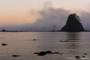
As this would be our first coastal backpacking trip, we obtained a permit for a fairly short and straightforward route beginning at Rialto Beach, heading north past the famous Hole-in-the-Wall, and eventually camping for two nights on the beach near the Chilean Memorial, the site of a shipwreck that killed 18 sailors all the way back in 1920. The terrain along this section of the coast was quite variable, ranging from long stretches of soft, sandy beach, to the slightly more annoying cobble and pebble beaches, to large boulder fields and headlands that were somewhat difficult to navigate with a heavy backpack:

Picking our way along the rocky Olympic coast en route to our campsite at Chilean Memorial.

Tilted layers of sediment have been planed off by wave action near Hole-in-the-Wall, Olympic National Park, Washington.

Cape Johnson, Olympic National Park, Washington. With not much beach to speak of, this is a great example of a spot where being aware of the tide situation is essential!
After a little more than four miles of hiking, we arrived at the small, unnamed cove home to the Chilean Memorial and found a campsite just above the high-tide line among large pieces of driftwood. This sheltered cove made for a relatively quiet and peaceful camp, as the myriad rocks and sea stacks just offshore caught the brunt of the surf, limiting the amount of wave action reaching the beach. We enjoyed watching the landscape of the cove change over the next few days as the mist and tides repeatedly swallowed up and revealed the sea stacks and small rocky islands. We quickly discovered that the largest sea stack (pictured below) was connected to the mainland via a rocky isthmus at low tide, and ended up hiking out to it one evening to look back on our campsite.
View out into the Pacific Ocean at sunset from our campsite on the Chilean Memorial beach in Olympic National Park, Washington

Looking back toward the Chilean Memorial beach and Cape Johnson from the base of the large sea stack in the previous photo.
While we had our fair share of clouds and mist, it did clear up enough on one evening to reveal the night sky. The moon was just past full, so the Milky Way was only barely visible, but it was still fun to see the southern stars rise and set over the Pacific:

A faint hint of the Milky Way reveals itself despite the light cast by the rising moon (just behind the trees at left).
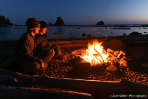
Enjoying a driftwood campfire on the beach.
Our trip came just a few days after the full moon, meaning that the low tides were some of the lowest of the month. These so-called “negative tides” are the best for exploring tide pools along the coast, as they reveal a greater variety of sea squishies:
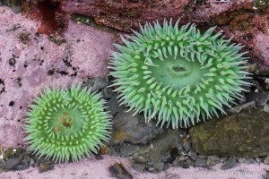
Two giant green anemones in a tidepool in Olympic National Park, Washington.

A crowded tidepool containing multi-colored aggregating anemones (Anthopleura elegantissima) in Olympic National Park, Washington

A tidepool filled with giant green anemones along the coast of Washington in Olympic National Park.
In addition to the living tidepool organisms, we also observed large quantities of dead jellyfish (at least three different species) washed up on the beaches, including several massive (~2 foot wide) lion’s mane jellies:
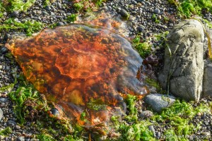
A deceased (?) lion’s mane jellyfish (Cyanea capillata) washed up on the beach in Olympic National Park, one of many, many such jellies we found on our trip.
For our third and final night, the original plan was to hike most of the way back to the car and camp along Rialto Beach near Hole-in-the-Wall. Prior to departure, the weather forecast for this night had called for a fairly robust storm coming in off the Pacific. With an ailing tent that has become somewhat more, shall we say, permeable than one would desire, we briefly debated whether to just call it quits to avoid the chance of getting soaked. Surprisingly, we were able to get enough cell service on the beach to check an updated weather forecast, which showed a drastically reduced chance of rain and little precipitation expected. Consequently, we decided to stick with the original plan and set up camp in the trees at the north end of Rialto Beach. Our decision to stay was quickly validated as we observed a number of whales spouting and breaching throughout the afternoon just offshore.
Our final campsite along Rialto Beach. From this vantage point, we saw a number of whales (likely humpbacks) spouting and breaching off-shore throughout the afternoon and evening.
12 hours later, at 3 AM, when I was emerging from the tent for the third time to re-secure our tarp and shelter in the face of driving rain, wind, and large, deafening waves crashing up against the bluff just a few feet from our tent, I wasn’t so sure. A great example of the fickle coastal weather I suppose, and a good character building experience as Calvin’s dad would say.
While intense, the storm was brief, and by morning the skies were clearing, making for a pleasant stroll down Rialto Beach back to the car. All in all, the trip was a refreshing change of scenery from our predominantly mountain-based adventures the rest of the summer!
Benign clouds greeted us in the wake of the storm for our short hike out to the car on the final morning.
Summiting Mt. St. Helens


Looking east along the crater rim of Mt. St. Helens to Mt. Adams in the distance.
Of all the volcanoes in the northern Cascades, Mt. St. Helens is by far the easiest to climb. For starters, the most common route, Monitor Ridge on the south flank, is non-technical, eliminating the need for specialized gear or advanced mountaineering skills. At just 8,366 feet, its summit elevation post-1980 eruption places it several thousand feet lower than neighbors such as Mt. Adams, Mt. Baker, and Mt. Rainier, essentially taking the ill effects of altitude out of the equation. However, at 10 miles round trip and with about 5,000 feet of elevation gain, it’s still a robust day hike.
After numerous trips to the base of Mt. St. Helens over the years, reaching the summit of this active volcano has long been on my to-do list. When we moved back to Washington last summer, I knew I might finally get my chance. The Gifford Pinchot National Forest limits the number of climbers to 100 per day in the summer months, and the permits sell out quickly when they go on sale in March. Sadly, I missed the initial sale this year, leaving me to obsessively check every few days for cancellations. Eventually I got lucky and spotted two permits up for grabs in late-July. A few minutes later, they were mine.
From a distance and elevation gain standpoint, the hike up Monitor Ridge is comparable to many of Colorado’s famous “Fourteeners”. One major difference: on Mt. St. Helens we would be topping out at a lower elevation than one starts most Fourteener climbs at. The other big difference would be the terrain. Most Fourteeners have a fairly distinct path a good way up the mountain and are on reasonably solid rock (my dislike of exposure and falling means I haven’t done any of the ones on rotten rock). On Mt. St. Helens, after a brief foray through the forest, the climb traverses a mixture of large lava boulders and a loose scree consisting of pumice and volcanic ash. This is a hike where a mask was on the suggested gear list before they were cool!
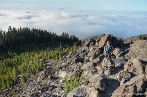
To the hike! As the National Weather Service had accurately predicted several days in advance, the morning of our climb dawned with some fairly dense fog at the Climbers Bivouac trailhead where we had camped the previous night. We hit the trail at 6:00 am, anticipating that it would take us 4-5 hours to reach the summit. The first two miles of trail climbs gently through a moist and somewhat unremarkable second growth forest. At timberline is where the route changes from a well-maintained trail to the aforementioned scree and boulder scramble. Wooden posts serve as guides for the remainder of the climb, but following them too closely didn’t always make for the most sensible route. In places there is a fairly obvious path, while in others (particularly in the boulder fields), you just sort of have to find what works best. Just before arriving at timberline, we began to emerge from the clouds, revealing views of Mt. Adams to the east and the extremely conical Mt. Hood to the south that we enjoyed the rest of the day. Once above the trees, our pace slowed significantly, but before too long we were several hundred feet above the cloud deck we had been immersed in a short time earlier:
Breaking out of the trees on the Monitor Ridge route.

Heading up Mt. St. Helens with the clouds below us and Mt. Hood in the background.
Nearing the top of the boulder field on the Monitor Ridge route. Only a mile to go!
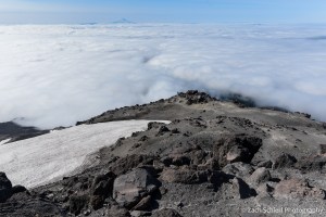
We made fairly good time through the ~2 miles of boulder fields. The final mile through a deep and loose mixture of volcanic ash and pumice was definitely the most challenging part of the hike. With masks on to prevent inhaling clouds of ash kicked up by our feet (and the wind), it was somewhat analogous to hiking up a sand dune: two steps forward, one step back, repeat. After about four hours, we were standing on the crater rim.
The first view northward into the bowels of Mt. St. Helens was stunning, and definitely one of the most dramatic viewpoints I can recall. Unlike many lesser peaks in the Cascades, or most peaks in the Rockies, where you are often surrounded by other peaks of comparable elevation, Mt. St. Helens stands alone. On this volcano, you are standing on what is, by far, the highest point for dozens of miles in any direction, with only the other volcanoes exceeding you in height. Looking down onto the crater formed by the 1980 eruption, the lava domes that are slowly rebuilding the summit, and the Crater Glacier (one of the few alpine glaciers in the world that is actually advancing) was spectacular. Cornices of hard-packed, dirty snow clung to the nearly vertical slopes of the crater walls just beneath our feet, necessitating caution as we moved our way along the rim. Gentle puffs of steam were visible on portions of the lava dome, a gentle reminder that we were standing at the summit of one of the most active volcanoes in the world. The dull roar of rock and ice fall from the crater walls was nearly constant for the hour we spent taking in the view from the summit.

Panorama from the Mt. St. Helens crater rim, looking north across the lava dome and Crater Glacier to Spirit Lake and Mt. Rainier. (Click image to enlarge)

Panorama looking south from the crater rim. Mt. Adams at left, Mt. Hood just left of center. (Click image to enlarge)
Clouds part to reveal Spirit Lake and the distant cone of Mt. Rainier, more than 4,000 feet higher that Mt. St. Helens.
While the hike up had been relatively uneventful, the journey down was definitely less pleasant. Hiking poles are a must for the descent due to the steep, loose, and rocky terrain. This is definitely one of those hikes where coming down is exponentially more difficult than going up!
Compared to our experience hiking Fourteeners in Colorado, the significantly lower elevation of this hike makes a huge difference and in my opinion dramatically lowers the overall difficultly of this route. There is a big difference between inching your way up a scree slope at 13,000′ and having to stop every few steps to take in oxygen, and doing the same at 8,000′ where breathing isn’t as much of an issue. While the terrain was definitely more difficult than your average hike with similar specs, in the end we felt like the difficulty of the Monitor Ridge route was somewhat over-hyped based on some of the accounts we read in advance. We wouldn’t hesitate to do it again. As far as special gear, a mask was definitely helpful for both COVID and volcanic ash purposes. Hiking poles were more or less useless on the way up, as the boulder fields often required the use of hands to navigate, but essential on the way down. Other sources recommended bringing garden gloves to protect against cuts on the sharp volcanic rocks. We bought some cheap ones and definitely found them useful. I never actually put mine on during the ascent, and made it to the summit with only one small abrasion on the back of my hand. Long pants are also a must if you don’t want your lower legs ripped to shreds by the rocks.
With Mt. St. Helens checked off, next up on the to-do list is Mt. Adams, which is also a non-technical climb at the right time of year, albeit longer. We may not get to that one this summer…perhaps our goal will be to climb one Cascade volcano per year!
