Throwback Thursday: Glacier Peak


Glacier Peak…the top of it at least. This was about the most we saw of it on our three-day trip.
While we wait for the snows to melt once again, time for another flashback to 2020. I realize that phrase likely strikes fear in the hearts of most, so feel free to pretend these photos are from some other year. While it was a rough year in many ways, the wilderness was just as spectacular as ever!
For a while last summer, our goal was to camp in the shadow of every active Cascade Range stratovolcano in Washington and Oregon. We ended up getting to 8/10, but late season plans for Mt. Baker and Mt. Jefferson ended up being derailed by fires, weather, or both. In total we camped 28 nights and hiked/backpacked over 250 miles in our COVID-safe exploration of the Cascades last summer. To minimize contact with others (and to save money), we eschewed developed campgrounds in favor of dispersed camping. Aside from backpacking permits, we paid for accommodations just once the entire summer, at a five-site Forest Service “campground” on the north side of Mt. Hood that we ended up having all to ourselves for the night.
One of our most memorable excursions was a quick two-night backpacking trip to the Glacier Peak and Henry Jackson Wilderness areas in north-central Washington.
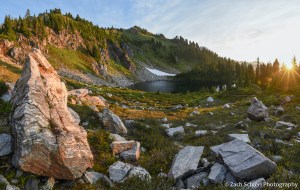
Early morning light at a campsite along the Pacific Crest Trail in the Henry Jackson Wilderness Area of central Washington
Of all the active volcanoes in the Cascade Range, Glacier Peak is by far the most difficult to glimpse up close. Tucked away in the north Cascades, reaching the vicinity of the Glacier Peak edifice requires a hike of at least 10-12 miles, making a backpacking trip really the only way to truly experience the mountain. For us, it was a ~35 mile, 3-day, 2-night trip beginning from the valley of the Little Wenatchee River. While were able to get quite close to the mountain, this was (amazingly) the only trip of the summer where the weather didn’t really cooperate with our desire to see the mountain in whose shadow we were camping. We got a handful of summit glimpses through breaks in the clouds, but Glacier Peak was obscured for the majority of our trip.

Tantalizing glimpses of Glacier Peak through the low clouds.
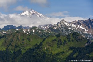
A fleeting view of the glacier-clad (not surprisingly) summit of Glacier Peak.
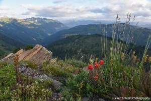
Looking down the Little Wenatchee River valley with some late season paintbrush providing a splash of color.
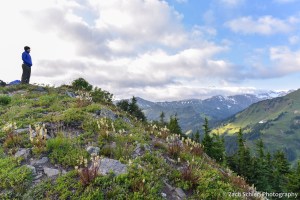
The view from Kodak Peak in the Glacier Peak Wilderness. Glacier peak is behind those clouds somewhere!

A marmot enjoys the view from Kodak Peak.
Despite the lack of peak views, the rugged, high altitude terrain was stunning and while we were a little too late for peak wildflower season, there were still lots of blooms covering the slopes:

Tiger lilies (Lilium columbianum) in the Glacier Peak Wilderness, Washington
The most memorable elements of the trip came on Day 3. After a COLD morning and a close brush with hypothermia, we decided (based largely on consulting with other hikers) to take a slightly longer, but less steep, route back to the car. Our ascent two days earlier had been short, steep, and rocky, and we weren’t thrilled about the idea of descending the same trail with heavy packs. Plus an alternate trail back to the car would result in a loop and who doesn’t love a good loop? According to maps and other hikers, our descent would be about 8-9 miles, instead of the six miles we had come up. Despite the modest mileage, it ended up being quite the slog. I’ve done enough hiking and backpacking that I normally feel pretty confident estimating mileage, and that descent sure felt like a LOT more than 9 miles. The trail was in decent shape, save for crossing a series of avalanche chutes choked with head high brush. Someone had kindly taken a machete to some, but not others. By the time we got back to the car, I was spent to put it mildly. I honestly can’t ever remember being so totally wiped out after a hike in my life.
Thankfully there was a bag of Chex mix waiting for me at the car. A few moments after diving in, I realized that the container it had been in was filled with mice droppings…and we soon noticed that the rest of the car was as well. Yum!
