Backpacking the Olympic Coast

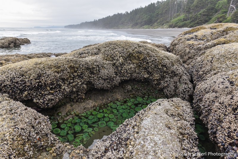
A tidepool filled with giant green anemones (Anthopleura xanthogrammica) along the coast of Washington in Olympic National Park.
Living in the desert of central Washington, it can be easy to forget that we live in a state with over 3,000 miles of coastline. While the high volcanic peaks of the Cascades are visible from our backyard (and thus remind us of their presence daily), the damp shores of the Pacific remain out of sight and out of mind most of the time.
Our most recent summer trip took us all the way to Washington’s western edge for a short backpacking trip along the coast in Olympic National Park. Coastal backpacking comes with a few unique challenges. For starters, predicting the weather along the coast is notoriously difficult, in part due to the relative lack of surface weather observations over the eastern Pacific and Gulf of Alaska, where most of our storm systems approach from. This fact ended up rearing its head on the final night of our trip.
Perhaps even more importantly, safe coastal backpacking requires that you know how to read a tide chart. The Washington coast experiences a fairly large tidal range, up to 10-12 feet during certain parts of the month. That’s enough to make vast sandy beaches completely disappear. A successful trip requires acute awareness of the timing and magnitude of the twice-daily high and low tides. The coast features many headlands (rocky outcroppings that jut out into the sea, often without any sort of “beach” whatsoever) that can only be traversed when the tide is below a certain level. Getting the timing wrong can (at best) result in having to sit on the beach for hours waiting for the tide to go out or (at worst) getting trapped in a dangerous situation as the tide rises and cuts off your escape route.
As this would be our first coastal backpacking trip, we obtained a permit for a fairly short and straightforward route beginning at Rialto Beach, heading north past the famous Hole-in-the-Wall, and eventually camping for two nights on the beach near the Chilean Memorial, the site of a shipwreck that killed 18 sailors all the way back in 1920. The terrain along this section of the coast was quite variable, ranging from long stretches of soft, sandy beach, to the slightly more annoying cobble and pebble beaches, to large boulder fields and headlands that were somewhat difficult to navigate with a heavy backpack:
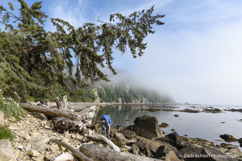
Picking our way along the rocky Olympic coast en route to our campsite at Chilean Memorial.

Tilted layers of sediment have been planed off by wave action near Hole-in-the-Wall, Olympic National Park, Washington.

Cape Johnson, Olympic National Park, Washington. With not much beach to speak of, this is a great example of a spot where being aware of the tide situation is essential!
After a little more than four miles of hiking, we arrived at the small, unnamed cove home to the Chilean Memorial and found a campsite just above the high-tide line among large pieces of driftwood. This sheltered cove made for a relatively quiet and peaceful camp, as the myriad rocks and sea stacks just offshore caught the brunt of the surf, limiting the amount of wave action reaching the beach. We enjoyed watching the landscape of the cove change over the next few days as the mist and tides repeatedly swallowed up and revealed the sea stacks and small rocky islands. We quickly discovered that the largest sea stack (pictured below) was connected to the mainland via a rocky isthmus at low tide, and ended up hiking out to it one evening to look back on our campsite.
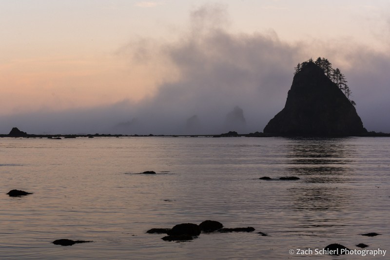
View out into the Pacific Ocean at sunset from our campsite on the Chilean Memorial beach in Olympic National Park, Washington

Looking back toward the Chilean Memorial beach and Cape Johnson from the base of the large sea stack in the previous photo.
While we had our fair share of clouds and mist, it did clear up enough on one evening to reveal the night sky. The moon was just past full, so the Milky Way was only barely visible, but it was still fun to see the southern stars rise and set over the Pacific:
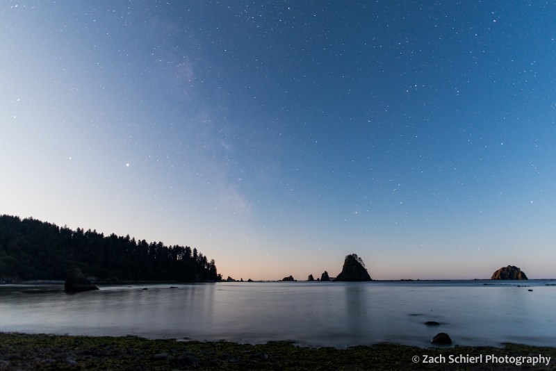
A faint hint of the Milky Way reveals itself despite the light cast by the rising moon (just behind the trees at left).

Enjoying a driftwood campfire on the beach.
Our trip came just a few days after the full moon, meaning that the low tides were some of the lowest of the month. These so-called “negative tides” are the best for exploring tide pools along the coast, as they reveal a greater variety of sea squishies:

Two giant green anemones in a tidepool in Olympic National Park, Washington.

A crowded tidepool containing multi-colored aggregating anemones (Anthopleura elegantissima) in Olympic National Park, Washington
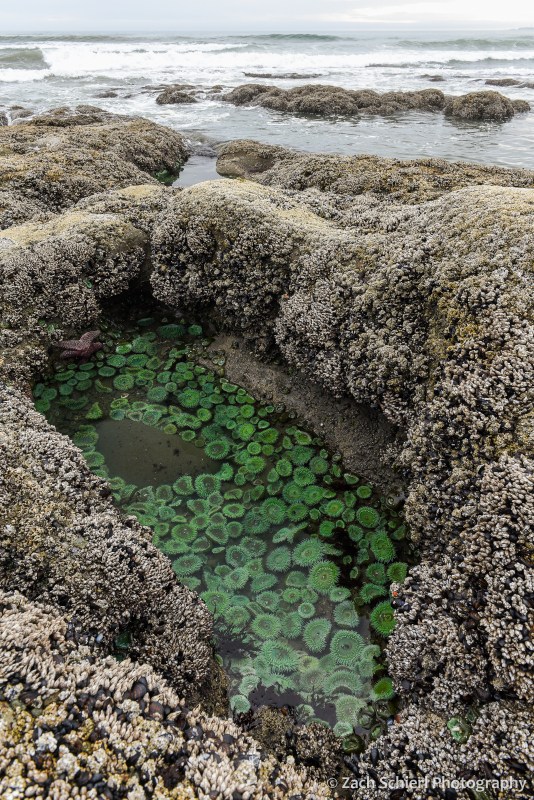
A tidepool filled with giant green anemones along the coast of Washington in Olympic National Park.
In addition to the living tidepool organisms, we also observed large quantities of dead jellyfish (at least three different species) washed up on the beaches, including several massive (~2 foot wide) lion’s mane jellies:

A deceased (?) lion’s mane jellyfish (Cyanea capillata) washed up on the beach in Olympic National Park, one of many, many such jellies we found on our trip.
For our third and final night, the original plan was to hike most of the way back to the car and camp along Rialto Beach near Hole-in-the-Wall. Prior to departure, the weather forecast for this night had called for a fairly robust storm coming in off the Pacific. With an ailing tent that has become somewhat more, shall we say, permeable than one would desire, we briefly debated whether to just call it quits to avoid the chance of getting soaked. Surprisingly, we were able to get enough cell service on the beach to check an updated weather forecast, which showed a drastically reduced chance of rain and little precipitation expected. Consequently, we decided to stick with the original plan and set up camp in the trees at the north end of Rialto Beach. Our decision to stay was quickly validated as we observed a number of whales spouting and breaching throughout the afternoon just offshore.

Our final campsite along Rialto Beach. From this vantage point, we saw a number of whales (likely humpbacks) spouting and breaching off-shore throughout the afternoon and evening.
12 hours later, at 3 AM, when I was emerging from the tent for the third time to re-secure our tarp and shelter in the face of driving rain, wind, and large, deafening waves crashing up against the bluff just a few feet from our tent, I wasn’t so sure. A great example of the fickle coastal weather I suppose, and a good character building experience as Calvin’s dad would say.
While intense, the storm was brief, and by morning the skies were clearing, making for a pleasant stroll down Rialto Beach back to the car. All in all, the trip was a refreshing change of scenery from our predominantly mountain-based adventures the rest of the summer!

Benign clouds greeted us in the wake of the storm for our short hike out to the car on the final morning.
Views of Tahoma


Light from a nearly full moon illuminates the glaciers and icefields on the summit of Mount Rainier.
At 14,411 feet, Mount Rainier is the highest peak in Washington and in the entire Cascade Range. British naval officer Peter Rainier never even saw the mountain that now bears his name, but he had a friend that did. Clearly, it paid to have connections in the 1700s. Oddly, Rainier did fight against the Americans during the Revolutionary War, making the fact that we continue to utter his name when referring to this grand peak all the more peculiar. Mount Rainier was originally known as Tahoma or Tacoma by the Salish-speaking indigenous tribes of the Pacific Northwest. There are periodic rumblings about renaming the peak, much like the name of Alaska’s Mount McKinley was officially reverted to Denali in 2015. Hopefully that will indeed happen someday…
Irrespective of name, Tahoma dominates the skyline from Seattle and much of the Puget Sound region. Tacoma and other towns to the south of Puget Sound are literally built on layers of debris deposited by gigantic lahars (volcanic mudflows) that periodically race down its flanks, filling river valleys on their way to the sea. The threat of future lahars and volcanic activity looms over those who live in its shadow. From my vantage point in the Yakima Valley of central Washington, the foothills of the Cascades obscure all but the uppermost few hundred feet of its glacier-clad summit (and which will, thankfully, block any future lahars). Obtaining a better view requires venturing into the mountains. Recently, we spent a weekend camping high on a ridge about a dozen miles to the south of the volcano’s summit. Our campsite in an old clear cut provided stellar, if slightly obscured views of Tahoma’s bulk.
The weather was quite variable throughout the weekend, ranging from mostly clear (but hazy) upon arrival, to partly cloudy, to overcast, to bouts of dense fog. Our view of the mountain was constantly changing. One evening I decided to capture a time-lapse of cloud movement and formation in the two hours leading up to sunset:
Sadly I did not notice the beer can stuck on top of the tree in the foreground until it was too late. Oh well. On another evening, a spectacular stack of lenticular clouds developed over the summit:

A series of stacked lenticular clouds above Mt. Rainier.

Closer view of the stacked lenticular clouds.
A nearly full moon provided sufficient light for photographing the mountain after dark:

Tahoma bathed in the light of a nearly full moon.
Not to be outdone by Tahoma, the pinnacle of High Rock just to our west also put on quite the show at sunset, with the light of the setting sun casting an amazing shadow of the peak and it’s summit lookout tower on the foreground mists:

Sunset, High Rock, Gifford Pinchot National Forest, Washington

A nearly full moon rises over the forests of the Cascade Mountains.
After this trip and our stunning view of Mt. Adams a few weeks ago, our goal for the summer is now to camp in the shadow of all of Washington and northern Oregon’s stratovolcanoes. Next up: Mt. St. Helens!
Crossing the Channel


Potato Harbor, Santa Cruz Island, Channel Islands National Park, California
Just a few dozen miles off the coast of Southern California lie the Channel Islands, eight motes of land jutting out of the sea a stone’s throw from the hustle and bustle of the Los Angeles metropolitan area. Of the eight islands, the only one with a significant human population is the tourist mecca of Santa Catalina, which draws over one million visitors per year. The remaining seven islands are sparsely populated and draw far fewer tourists. The four northernmost islands form an archipelago that is protected by Channel Islands National Park and the Nature Conservancy.
Back in March, we briefly visited the largest Channel Island: Santa Cruz. At 97 square miles in area, Santa Cruz is reached via ferry from Ventura or Oxnard. Our hour-long journey across the Santa Barbara Channel was choppy to say the least, but included close up views of Pacific white-sided dolphins and several majestic oil drilling platforms. Upon arrival, we were greeted by one of the most lush landscapes imaginable. Abnormally abundant winter rains had produced a tall, dense carpet of green grasses that blanketed the entire island. One of the resident rangers told us it was the greenest he had seen Santa Cruz in the seven years he’d worked there.

A trail winding through the lush spring grasses on Santa Cruz Island, Channel Islands National Park

Looking east from Santa Cruz toward Anacapa Island, Channel Islands National Park

Campsite on Santa Cruz Island, Channel Islands National Park. Landscape illuminated by a first quarter moon.
Given their relative geographic isolation, the Channel Islands are notable for their high concentration of endemic plant and animal species found nowhere else on Earth. They are also home to some of the earliest evidence of human habitation in the Americas. Archaeological and geological evidence suggests that humans inhabited Santa Rosa, just east of Santa Cruz, as far back as 13,000 years ago. At this time, sea levels were much lower due to the massive amounts of water locked up in glaciers and ice sheets farther north. As a result, the four northernmost islands (Anacapa, Santa Cruz, Santa Rosa, and San Miguel) were united into a “mega island” whose eastern edge was much closer to mainland California. This made it easier for plants and animals to reach the island, either by air (birds, plant seeds, etc.) or on floating rafts of debris (mammals, reptiles, etc.) Some species may have even been deliberately brought to the islands by humans.
As the most recent glaciation ended, sea levels began to rise, eventually splitting the mega-island into the smaller landmasses that exist today. Once isolated, the plant and animal populations that had established themselves on the islands, either organically or after being brought there by humans, began to evolve into species distinct from their mainland cousins. In some cases, distinct subspecies have evolved on individual islands in response to unique conditions.


For visitors to Santa Cruz, the most obvious example of this phenomenon is the ubiquitous Santa Cruz island fox (Urocyon littoralis var. santacruzae). Coming from the mainland where a sighting (especially a daytime sighting) of a fox is a rare treat, we were surprised to see one within minutes of getting off the ferry. The island fox is descended from and appears very similar to the common grey fox, but is much smaller. A fully grown island fox weighs just 4-5 pounds, and is similar in size to a large house cat. Often the lush spring grasses exceeded the foxes in height, making them challenging to spot! Nearly extinct in the early 1990s, a highly successful habitat restoration and captive breeding program has the species thriving today. We ended up seeing several dozen in our short visit to Santa Cruz. Other subspecies of the island fox exist on five of the other seven islands, each with slight differences evolved in response to local conditions.

An island fox lurking in the tall grass

An island fox on the trail to Smugglers Cove, likely hoping for a food handout.
With its pastoral landscape and unique wildlife, Santa Cruz feels a world away from metropolitan areas of Southern California. However, nightfall brought a stark reminder of just how close the islands are to the urban sprawl. Light pollution from Los Angeles, Oxnard, Ventura, Santa Barbara, and the numerous oil drilling platforms in the Santa Barbara Channel dominated the night sky from Santa Cruz.

Nighttime panorama from the cliffs above Scorpion Ranch on Santa Cruz Island. See annotated image below for a description of the different features.

Our return trip was delayed because the choppy seas prevented the ferry from reaching the anchorage on Santa Cruz on time, giving us a few extra hours to sit on the beach and enjoy the peace & quiet of the island. The winds died down enough for a smooth ride back across the channel where we even spotted a couple of migrating gray whales. Apparently I need more practice shooting photos from a moving platform, as the whale pics all turned out pretty blurry. Have another fox instead!

