A Hidden Geologic Gem: Ashdown Gorge


Inside a spectacular alcove along Ashdown Creek. Alcoves such as these are numerous along Ashdown Gorge where the stream has eroded laterally into soft rocks near the canyon bottom. The perspective here makes the alcove appear a little deeper than it actually is, but the entire creek bed lies beneath the overhanging cliffs.
Not far from the increasingly overrun splendors of Bryce and Zion is a canyon frequently overlooked when discussing the many attractions of Southern Utah. The stunning Ashdown Gorge lies just a few miles from Cedar City off of Highway 14, yet I’ve seen a grand total of three other people on a pair of weekend hikes up the gorge this summer & fall. The solitude likely stems from the fact that there is no marked trail or trailhead for this hike; Ashdown Creek is the trail for a spectacular jaunt up the canyon. One must also scramble down the steep toe of an active landslide strewn with old vehicles, guardrail fragments, and asphalt chunks just to reach the creek bed from the highway. Once this has been accomplished though, it is fairly easily walking for many miles up the gorge as the water in the creek is typically only ankle deep except during spring snow melt and after heavy rains.

Beautiful colors in a narrow section of Ashdown Gorge.
Ashdown Gorge has a very different character than many canyons in Southern Utah, starting with the color of its walls. Not red or pink – the famous layers of Zion and Moab are well below the surface here – but rather varied shades of grey, tan, and yellow. The majority of the gorge is carved into the Cretaceous Straight Cliffs Formation, an impressive unit formed when southwestern Utah was a swampy coastal plain trapped between a disintegrating mountain range to the west and the shallow Cretaceous Interior Seaway to the east. Periodic but short lived rises in sea level are marked by occasional beds that contain almost nothing but fossilized oysters and other marine organisms.

Not far from the junction of the gorge and Highway 14 is a gigantic boulder of the Straight Cliffs Formation displaying some of the best preserved ripple marks I’ve ever seen!
Ashdown Gorge is not quite a slot canyon, although it tries in places. Despite this, the walls for much of its length are several hundred feet high and there are many locations where you would NOT want to find yourself during a flash flood, so take a close look at the weather forecast before attempting to explore the gorge! Unlike the relatively hard sandstone that forms most of Utah’s famous slot canyons, the Straight Cliffs Formation is rather soft and crumbly. The creek has taken advantage of this by eroding laterally in many places. The result of this erosion is perhaps most spectacular around the outside edges of the many tight meanders of Ashdown Creek. Here the creek has carved into soft layers near the canyon bottom, undercutting harder layers of sandstone near the rim, creating vast alcoves that completely cover the creek bed.

Inside another alcove further downstream. Beneath this one were a plethora of large, partially pulverized blocks of grey rock that had clearly fallen quite recently (they had not yet been covered in the orange mud like most of the rocks in the creek bed) from the overhang above. We chose not to stick around in this one for long…
While walking along the creek, one thing that is striking is the color of the boulders upon which you walk. Not grey and tan like the canyon walls, but rather varying shades of orange, pink, and red. This is because Ashdown Creek drains the vast amphitheater of Cedar Breaks National Monument upstream to the east. The soft limestones and siltstones of Cedar Breaks are easily eroded, and Ashdown Creek can turn bright orange during even minor rains.

Flanigan Arch from Ashdown Gorge
Another highlight of a hike up Ashdown Gorge is a good view of Flanigan Arch, an impressive span (reputable estimates of its length are hard to find, but most seem to say ~60 feet) that is difficult to access or even see from any other location.
In addition to the lack of crowds, the high elevation of Ashdown Gorge (7000-8000′) makes it a wonderful day hike (or potential overnight trip) for escaping the heat in summer (just watch for flash floods…) Ponderosa Pine, spruce, and fir are the most commonly seen large trees in the gorge which has a very “mountainous” feel to it. When we hiked it in late October, the temperatures were actually getting a little too cool to fully enjoy the numerous required stream crossings. In June when it was 80 degrees, the creek crossings were heaven!

Some small riffles along Ashdown Creek.

Hiking up the gorge is fairly easy, a few small riffles and waterfalls can be easily scrambled around.
Greyrock Trail Loop, Poudre Canyon, Colorado


Greyrock Mountain and Greyrock Meadow
And now for a few more photos from before winter roared back into Colorado this past week:
Earlier this winter we took a day trip up Poudre Canyon, about a half hour northwest of Fort Collins. One of the more popular trails here is a ~5.5 mile loop combining the Greyrock Trail and the Greyrock Meadows Trail. A short spur trail heads up to the summit of Greyrock Mountain (pictured above) near the apex of the loop but we opted to pass on this route due to icy conditions and dwindling daylight. Despite ranging in elevation from 5,500-7,000 feet, the trail was surprisingly snow free, save for the lower sections that were well-shaded by the canyon walls.
The highlight of the hike is most certainly the spectacular granitic rock formations surrounding Greyrock Mountain. I say granitic because the rock here is actually not granite but what geologists call quartz monzonite; essentially granite with slightly less quartz and slightly more feldspar (hence the pinkish color). A seemingly trivial difference perhaps but an important one to geologists trying to unravel the history of the rocks. The steep, smooth faces of Greyrock Mountain wouldn’t look out of place amongst the granite domes of Yosemite National Park. There’s also some good sized pegmatite dikes that criss-cross the area. We found some very large and attractive quartz and feldspar crystals poking around the meadows that surround Greyrock Mountain.

Standing on a large pegmatite dike looking down into Greyrock Meadow. The continuation of the dike can be seen as the prominent vertical pink stripe on the hillside just beyond the meadow.
On a non-geology note, the trails winds through several different burn scars, apparently of different ages based on the amount of regrowth in different areas. Many of these burned areas are likely due to the High Park Fire of 2012, one of the largest wildfires in Colorado’s history which ravaged the lower sections of Poudre Canyon. There had apparently been a large windstorm here recently, as there were numerous downed trees, some dead snags but some still very much green and alive, strewn across the trail:

One of many large, recently downed Ponderosa Pines on the Greyrock Meadow Trail.
On the hike back down to the trailhead (on the Greyrock Meadows Trail), we were treated to a spectacular sunset over Poudre Canyon as well as views of the distant Mummy Range in Rocky Mountain National Park.

Golden hour light looking east down Poudre Canyon

Sunset over Poudre Canyon
The grand old Rocky Mountains!

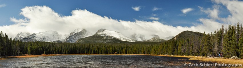
Clouds linger over the Continental Divide as seen from Bierstadt Lake
The grand old Rocky Mountains!
Their bold and massive forms,
Like Pyramids of age,
Defy the sweeping storms!
-Enos A. Mills, 1887
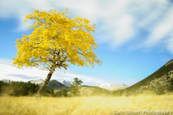
A hectic few months has kept me away from the website recently but fortunately not from my camera. My recent move to Fort Collins, CO means that my new backyard playground is Rocky Mountain National Park, only an hour from my doorstep and home to some truly spectacular scenery, especially in the fall when the aspens and willows turn golden and storms begin to dust the high alpine tundra with snow.

Fall colors along Bear Lake Road
My arrival in Fort Collins happened to coincide with the annual fall elk rut, in which bull elk gather large groups of females (called harems) together to mate. The many large grassy parks in RMNP are a popular gathering place for the elk and hundreds of people can be found lining the roads and trails skirting the meadows each evening to observe them in action. Even though I used to regularly see elk in our backyard growing up, this was a new experience for me. After an evening of watching and photographing the bull elk mate, lock antlers with other males, and toss back their heads to bugle, I can now confidently check “witness an elk rut” off my non-existent bucket list. I would share some of my photos of this unique spectacle, but in order to keep this website rated PG-13, I had better pass…

An elk cow shares a tender moment with her calf.
While snow starts to fall in the high Rockies in late September or early October, the weather usually remains pleasant well into October or even November. We’ve had a few storms the past few weeks that have dropped some not insignificant amounts of snow in the high country so every hike I’ve taken so far has been an exercise in scouting trails less likely to be covered in snow and ice.

The Loch Vale in Rocky Mountain National Park
Earlier this week I decided to hike to the base of the east face of Longs Peak and Chasm Lake. I was unsure if I would actually be able to make it to the lake given its 11,700 foot elevation but I had picked Chasm Lake because I had noticed that the last (and highest) mile of trail hugged a south facing slope. A south facing slope equals more direct sun and theoretically less snow. My scouting paid off; the trail was nearly snow free save for some hard packed, but easily traverse-able snow just above tree line and the final 200 yards to the lake. The final 200 yards presented a bit of a challenge: a 30 degree slope guarding the lake that was basically one gigantic ice rink. I wasn’t going to be getting up the main trail without crampons but thankfully, a series of rock ledges alongside the trail were solid and dry, providing an alternative route up the final 200 vertical feet to the lake with only a little Class 3 scrambling required. Upon finally reaching the lake, I was met by a wonderful late autumn scene and quite happy to have avoided the the colossal disappointment of hiking 4+ miles only to get turned around with only a few hundred yards to go.

The Ships Prow (left) and Longs Peak (14,259′, right) tower above Chasm Lake
The snow and ice had the added benefit of deterring the crowds that seem to linger in the park well into the fall. The previous week I had hiked to Loch Vale in a busier section of the park and just getting to the trailhead had involved being stuffed like sardines in a park shuttle bus. Chasm Lake though I had all to myself for over an hour, save for a pair of climbers descending from Longs Peak, the highest summit in the park. The east face of Longs Peak is an imposing sight, “abrupt and precipitous for three thousand feet” according to Enos A. Mills, an early resident of the area and the driving force behind the creation of Rocky Mountain National Park in 1915. The silence was stunning, save for the occasional high-pitched “eeeeeeeee” of a pika, the intermittent roar of the wind whipping up loose snow, and the din of fallen icicles and chunks of glacial ice crashing their way to the base of the cliffs.
At eve and morning lighted
With liquid gold all around,
Thy crests and hills and valleys
Gleam bright with glory crowned.
—Enos A. Mills, 1887
Aspen and grass waving in the wind in Horseshoe Park

Sunset and gibbous moon from Moraine Park
