Europe Part 8: Out of the Albanian Alps (and back home)


Links to previous posts: Part 1, Part 2, Part 3, Part 4, Part 5, Part 6, Part 7
We arrived in Theth early in the afternoon after our hike across Valbona Pass. Like Valbona, Theth is strung out along several miles of a narrow mountain valley, with a dizzying array of peaks rising into the sky. One major difference was the vegetation, which in and around Theth was extremely lush and almost felt more tropical than mountainous. We really enjoyed our time in Theth; it felt more like an actual community and was definitely more happening than Valbona. Our lodging on this side of the mountains was located close to what you might call the town center. In addition to the slew of guesthouses, there was also a small market, a bar, a few restaurants, a few museums and historical sites, a church, and even a national park information center with some nice interpretive signs on the natural and cultural history of area (but still a perplexing lack of hiking information or maps!)
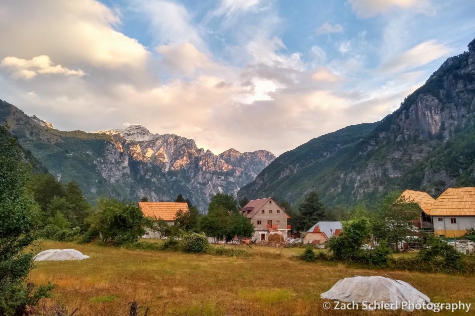
After our hike over from Valbona, we spent the rest of the afternoon relaxing and exploring town a bit, while waiting out a few more heavy downpours. We had rain and thunderstorms pretty much every afternoon in the Albanian Alps, a contrast to the sunny and hot weather we experienced everywhere else on the trip. Unlike our guesthouse in Valbona, the one we stayed at in Theth had a small restaurant that served dinner. We ended up eating there both nights because the food was so good; definitely our best meals in Albania! One great thing about Albanian food was the vegetables: fresh, delicious vegetables were served at every meal, unlike in Bosnia where they were often nowhere to be found. We also got to sample raki, a traditional Albanian liquor made with plums. It tasted pretty much like straight liquor or vodka to me…not my favorite.
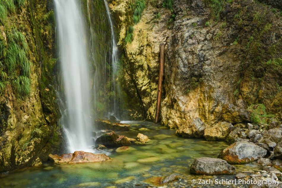
The classic hike in the Theth area is an all day, 12+ mile hike to the “Blue Eye” waterfall. At this point in the trip, we were starting to run out of gas so we decided to forgo the Blue Eye and set out on a somewhat more relaxing itinerary of visiting the (closer) Grunas Canyon and Grunas Waterfall, and then some of the attractions in Theth itself. The first part of the hike took us along the roaring Theth River and over a rickety little bridge with a concerning number of planks missing. Soon we arrived at the Grunas Canyon, a very deep and narrow slit carved into the limestone by the river. On the way back to town we detoured to the Grunas Waterfall, which was about 100 feet high and plunged into a very cold-looking pool of water with lots of moss, ferns, and other green vegetation growing around it. The waterfall was a busy spot despite the somewhat treacherous final approach and the intermittent rain. Several large groups of people came and went, the most people we ever saw in one place in all of the Albanian Alps!

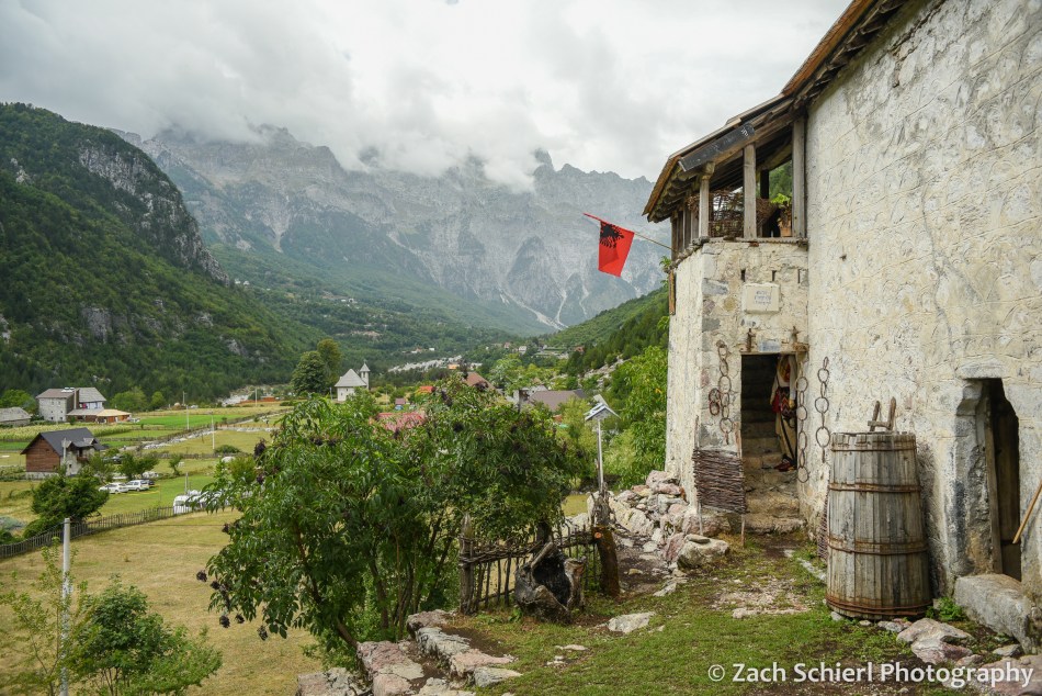
Once back in Theth, we followed a little trail across the fields and farms to the local history museum, located in a 330 year old house built on top of a gigantic rock. The museum caretaker lives next door and spotted us approaching. She ended up giving us a private tour of the museum, pantomiming the use of the many of the objects within to overcome the language barrier. If we understood correctly, it was actually the house that she had grown up in, though not 100% sure on that. Before we left, she insisted that we take home a bunch of fruit from the trees in the yard, so we ended up with a whole bag of very delicious plums of different sizes and colors. We stopped at the little Catholic church which, while quite new (1892) by European standards, is very unique on the outside and was extremely photogenic against the backdrop of the mountains.


The following morning we boarded a minivan to head back to Shkodër and then on to the Albanian capital, Tirana. The drive out of Theth was pretty spectacular. A very narrow and steep road switchbacks up the valley wall, with incredible views out across the mountains. This was actually still a dirt road until just last year. It is only about 45 miles from Theth to Shkodër, but it took close to three hours even with an entirely paved surface. The road is just a single lane until a few miles outside Shkodër, and there was enough traffic that we spent a lot of time pulling over to let other vehicles pass. We also discovered that public transportation in Albania involves making numerous unexplained stops on the side of the road. All part of the adventure!
In Shkodër we transferred to a bus that was headed for Tirana. This was another slow ride, as the two-lane highway between two cities was packed with traffic. We were a bit surprised when the bus suddenly and unexpectedly dropped everyone off on the outskirts of Tirana. Apparently the intercity buses are not allowed into the city center (where we were staying), which we were not aware of. We considered just walking, but it would have been several miles with all our luggage and would have required crossing a major freeway. We had also not eaten much or used the bathroom for many hours, so eventually we managed to procure a taxi to take us the last few miles into town.
After checking in to our hotel we set out to find dinner and explore Tirana. We ate at a restaurant in the “Tirana Castle,” which used to be a castle but now is an upscale shopping and dining corridor. We walked around the city a bit en route back to our room, passing through the massive Skanderbeg Square in the center of town.

Tirana seemed like a very nice city, but sadly this was the last I would see of it. I spent the next 24 hours in bed with food poisoning. Fortunately, it couldn’t have happened on a better day. We had scheduled a full day in Tirana before our departure as a “cushion day,” in case we encountered any travel delays in our journey up until this point. We hadn’t, so while I missed out on Tirana sightseeing, it didn’t affect our travel plans beyond that. Fortunately I was feeling somewhat better the following morning since we had to be at the Tirana airport by 3:30 am to begin our journey home. Leg 1 would take us across the Adriatic Sea from Tirana to Rome, where we had about a day and a half before our flight back to Canada and the U.S. In a twist of irony, we had added our long layover in Rome in part because, when we visited Italy in 2018, our day in Rome got partially torpedoed by…you guessed it…food poisoning! I had been looking forward to exploring Rome while fully healthy, but alas that was not to be.
Between the residual effects of food positioning, the fatigue of a month of travel setting in, only a few hours of sleep due to the early flight, and temps soaring to almost 100 degrees, we weren’t entirely sure what to do with ourselves in Rome. We ended up taking the Metro and then a bus to the outskirts of town to see the old Appian Way and the Catacombs of San Sebastiano. The catacombs are huge networks of underground tunnels where the Christians of Ancient Rome buried their dead. Very interesting, and a little creepy…pictures not permitted. Honestly though, what I remember best is that it was mercifully ~40 degrees cooler underground than on the surface. I never thought I’d be so grateful to spend half an hour in a underground crypt! The catacombs were located right along the Appian Way, one of the world’s first paved highways built over 2000 years ago to connect Rome to important points southward in Italy. The original basalt paving blocks are still intact and the road is still used as…a road! You can drive your car right down it. Fortunately this spot was far enough outside the city center that there wasn’t much traffic, so we walked down the Appian Way for a short distance but didn’t make it very far since it was so damn hot.
After a short nap back at the hotel, I was feeling mostly back to normal so we took the Metro again, this time to the Vatican City area where I ate my first solid food in almost 48 hours. After dinner we went on a whirlwind walking tour of Roman sights: The Vatican and St. Peter’s Square, the Tiber River, Plaza Navona, Trevi Fountain, the Pantheon, and the Spanish Steps. We had visited some of these sights in 2018 in our food poisoning induced stupor, so it was cool to see them again at a different time of year and in marginally better health.


Our flight back to Canada wasn’t scheduled to leave until 2:00 pm the following day, but we woke up to an email that it had already been delayed until 4:00 pm, so we ended up with another half day in Rome. Suffice to say that at this point, we were both feeling pretty tired and done with sightseeing. We walked around the Baths of Diocletian, the largest public baths in the Roman empire at one point (and right down the street from our hotel) for a few hours before heading to the airport. This turned out to be more challenging than expected, as the train line that connects central Rome to the international airport (about 30 minutes away) had been shut down due to a fire on the tracks. We ended up fighting for space on one of the handful of shuttle busses that travels between the central train station and the airport, getting there quite a bit later than planned. Fortunately the security line was basically nonexistent so we made it to the gate with plenty of time to spare.
Our flight to Calgary was uneventful. (Props to Westjet for getting us to and from Europe without issue during a summer of crazy travel chaos!) We got some nice views of the ice sheets and glaciers of Greenland and Baffin Island. Entering Canada was, surprisingly, a breeze. We had to fill out a bunch of COVID-related paperwork in advance to enter the country, but were never asked for any of it nor did we have to show our vaccine cards upon arrival. The biggest drama came when our cab driver from the airport to our hotel in Calgary almost ran me over as I was putting the bags in the car. We had a ~18 hour layover in Calgary, but were so tired and jet lagged that we barely left our hotel. The next morning was a short flight back to Seattle, where we strolled off the plane and into the terminal…through the same gate we had begun our journey through one month earlier!
It’s so hard to summarize a trip like this, especially in blog form, so I’m not really going to try apart from a few closing thoughts. For context, the distance between our starting point, Ljubljana, and ending point, Tirana, is roughly the same as the distance from Seattle to Klamath Falls, Oregon, so this trip really represented a pretty small corner of the world, one which we feel very fortunate to have had the opportunity to explore for a month. Looking back almost four months later, some of the experiences that stand out for me are: learning about the distinct yet intertwined culture and history of five different countries from a series of wonderful guides and hosts. Trying a huge array of amazing foods (had we not done an insane amount of walking, I think we would have come back somewhat heavier!) The ease and comfort of getting around via public transportation in Europe (Mostar—>Dubrovnik bus excluded.) And, of course, photographing the cities and landscapes of the Balkans was a lot of fun. In the end, we got through a month-long trip abroad and the worst thing that happened was my bout of food poisoning…pretty good I think!
Thanks for following along. Next it will be back to our regularly scheduled programming: photos of the Pacific Northwest!

Pyroclastic Pixels Goes to Italy!


The village of Vernazza occupies rocky cliffs and ravines along the Ligurian Coast of Italy.
We recently returned from a week in Italy; a refreshing change of pace, both scenically and climatically, from winter in the Utah desert! While we spent the majority of the trip enjoying the historic sights of Florence and Rome, just a handful of hours after touching down in Italy, we were aboard a high-speed train bound for the Cinque Terre, a rugged section of Ligurian Sea coastline where we spent the first several days of our trip hiking, exploring, and ingesting some of the best seafood of our lives. The Cinque Terre (“five lands”) consists of five small villages clinging to the rocky shore, surrounded by ancient stone terraces, vineyards, and olive groves, and crisscrossed by a network of hiking trails that, since 1999, have been part of the Cinque Terre National Park. A hot tourist spot in peak summer season, in March, with the temperatures still far too cold and the skies much too drizzly for a dip in the sea, the streets and trails were definitely still enjoying the relative calm of the off-season. On the stormiest day, we struggled to find an open restaurant or market to grab a bite to eat!
The five villages (from south to north: Riomaggiore, Manarola, Corniglia, Vernazza, and Monterosso al Mare) are spread out along a six mile stretch of shoreline. A regular train connects the five villages to one another and the larger cities of Liguria, making its way along the coast via a series of long, dark tunnels, only to pop out into the open briefly to stop at the station adjacent to each town. Coming from La Spezia (the closest major city to the Cinque Terre), we hopped off the train at Manarola, our home base for our all-too-short stay:
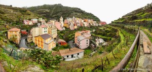
The train station in Manarola. A hundred-yard long pedestrian tunnel connects the station with the town, here seen peeking through gaps in the steep cliffs.
Like the other four towns, the colorful buildings of Manarola cling to the hillsides in impressive fashion. The terrain, while steep, is relatively easy to traverse thanks to the vast network of dry stone terraces, originally built centuries ago. Not only do the terraces help minimize erosion of the precipitous slopes, the treads provide flat surfaces on which grapes, olives, lemons, and other food products are grown. Most of the trails that wind through the Cinque Terre follow these historic terraces, providing an easy walking path, great views, and an up-close look at many of the vineyards which are still operated to this day.
The village of Manarola as seen from the terraced vineyards that surround the town.

A colorful sunset in Manarola, looking north along the Cinque Terre coast.

The Manarola waterfront at dusk.
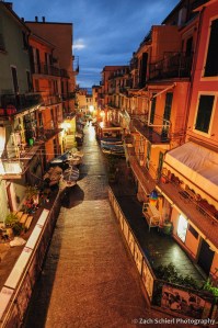
The streets of Manarola at night. The local fishermen had all removed their boats from the harbor for safe storage on the streets because of the storm and high surf.
Despite the convenience of the train, the most enjoyable way to travel between the towns is to walk. Hiking is one of the primary attractions here, and the five villages are connected by a famous 7-mile long coastal trail that follows the curves of the shoreline in dramatic fashion. So dramatic in fact, that many segments have been closed for years due to landslides that have made them dangerous and impassible. On day two, we struck out from Manarola to hike to the next village to the north: Corniglia. With the direct route along the coast closed indefinitely, we undertook a more circuitous route up through the vineyards and terraces to the village of Volastra, then back down a steep grade to Corniglia. The views of the Ligurian Sea from this trail were phenomenal, despite the occasional rain & thunder.
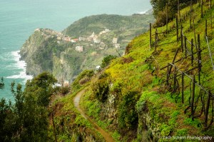
A damp hike through terraced vineyards on the “high trail” between Manarola and Corniglia.

We were surprised at the how many different kinds of agave and cacti graced the slopes of the Cinque Terre. It was odd to see so many of the familiar “desert” plants from our Utah home in such a temperate climate! Here, several agave cling to a vertical cliff not far from our lodging in Manarola.
After enjoying a picnic in Corniglia, we opted for a short rest and utilized the train to reach the next town of Vernazza. Vernazza was by far the busiest and most active town we visited; it was hard to imagine what the crowds would be like in the sweltering heat and humidity of summer. Interestingly, Cinque Terre, which attracts ~2.5 million visitors each year, faces many of the same challenges as Zion National Park in our own backyard: namely, lots of visitors and not a lot of room for them to spread out. The peak-season crowding has gotten bad enough that the Cinque Terre National Park, much like Zion, has begun exploring the use of reservation systems and other strategies to mitigate the crowds in peak season. Another parallel between Cinque Terre and Zion: deadly flash floods. In 2011, heavy rains swelled many of the streams that the villages are built along (or literally over in many places), killing several and burying the main streets of Vernazza and Monterosso in over a dozen feet of mud. While the towns have mostly recovered, the reality is that this will always be a very geologically active place. Nature doesn’t like near-vertical terrain.
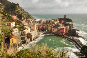
A view of colorful Vernazza from high above its harbor.

Looking southeast along the Cinque Terre coast from the coastal trail between Vernazza and Monterosso. Vernazza is the prominent village in the center of the photo; Corniglia and Manarola are just barely visible through the mist in the background.

The town of Levanto, just north of the Cinque Terre and the start of our hike to Punta Mesco
On our final day, we left the Cinque Terre proper and headed to the small town of Levanto, just to the north. Our plan was to hike a lesser known section of the coastal trail that traverses a wide peninsula jutting out into the Ligurian Sea, and then back to the Cinque Terre and Monterosso via Punta Mesco. Oddly, we saw far more people along this stretch of trail than we seen the past few days in the Cinque Terre, including an excursion of an Italian hiking club numbering at least 100 people. After a few dreary days, we finally got to bask in the beautiful Mediterranean sun on this trek, and were rewarded near the end with exquisite views of the entire Cinque Terre coast from Punta Mesco.

A panoramic view of the Cinque Terre from Punta Mesco along the coastal trail between Monterosso and Levanto.
A few days hiking (and eating) in the quiet and laid-back Cinque Terre were a great way to kick off our trip and ease us into tackling the hustle and bustle of Italy’s larger cities!
