A Hidden Geologic Gem: Ashdown Gorge


Inside a spectacular alcove along Ashdown Creek. Alcoves such as these are numerous along Ashdown Gorge where the stream has eroded laterally into soft rocks near the canyon bottom. The perspective here makes the alcove appear a little deeper than it actually is, but the entire creek bed lies beneath the overhanging cliffs.
Not far from the increasingly overrun splendors of Bryce and Zion is a canyon frequently overlooked when discussing the many attractions of Southern Utah. The stunning Ashdown Gorge lies just a few miles from Cedar City off of Highway 14, yet I’ve seen a grand total of three other people on a pair of weekend hikes up the gorge this summer & fall. The solitude likely stems from the fact that there is no marked trail or trailhead for this hike; Ashdown Creek is the trail for a spectacular jaunt up the canyon. One must also scramble down the steep toe of an active landslide strewn with old vehicles, guardrail fragments, and asphalt chunks just to reach the creek bed from the highway. Once this has been accomplished though, it is fairly easily walking for many miles up the gorge as the water in the creek is typically only ankle deep except during spring snow melt and after heavy rains.

Beautiful colors in a narrow section of Ashdown Gorge.
Ashdown Gorge has a very different character than many canyons in Southern Utah, starting with the color of its walls. Not red or pink – the famous layers of Zion and Moab are well below the surface here – but rather varied shades of grey, tan, and yellow. The majority of the gorge is carved into the Cretaceous Straight Cliffs Formation, an impressive unit formed when southwestern Utah was a swampy coastal plain trapped between a disintegrating mountain range to the west and the shallow Cretaceous Interior Seaway to the east. Periodic but short lived rises in sea level are marked by occasional beds that contain almost nothing but fossilized oysters and other marine organisms.

Not far from the junction of the gorge and Highway 14 is a gigantic boulder of the Straight Cliffs Formation displaying some of the best preserved ripple marks I’ve ever seen!
Ashdown Gorge is not quite a slot canyon, although it tries in places. Despite this, the walls for much of its length are several hundred feet high and there are many locations where you would NOT want to find yourself during a flash flood, so take a close look at the weather forecast before attempting to explore the gorge! Unlike the relatively hard sandstone that forms most of Utah’s famous slot canyons, the Straight Cliffs Formation is rather soft and crumbly. The creek has taken advantage of this by eroding laterally in many places. The result of this erosion is perhaps most spectacular around the outside edges of the many tight meanders of Ashdown Creek. Here the creek has carved into soft layers near the canyon bottom, undercutting harder layers of sandstone near the rim, creating vast alcoves that completely cover the creek bed.

Inside another alcove further downstream. Beneath this one were a plethora of large, partially pulverized blocks of grey rock that had clearly fallen quite recently (they had not yet been covered in the orange mud like most of the rocks in the creek bed) from the overhang above. We chose not to stick around in this one for long…
While walking along the creek, one thing that is striking is the color of the boulders upon which you walk. Not grey and tan like the canyon walls, but rather varying shades of orange, pink, and red. This is because Ashdown Creek drains the vast amphitheater of Cedar Breaks National Monument upstream to the east. The soft limestones and siltstones of Cedar Breaks are easily eroded, and Ashdown Creek can turn bright orange during even minor rains.

Flanigan Arch from Ashdown Gorge
Another highlight of a hike up Ashdown Gorge is a good view of Flanigan Arch, an impressive span (reputable estimates of its length are hard to find, but most seem to say ~60 feet) that is difficult to access or even see from any other location.
In addition to the lack of crowds, the high elevation of Ashdown Gorge (7000-8000′) makes it a wonderful day hike (or potential overnight trip) for escaping the heat in summer (just watch for flash floods…) Ponderosa Pine, spruce, and fir are the most commonly seen large trees in the gorge which has a very “mountainous” feel to it. When we hiked it in late October, the temperatures were actually getting a little too cool to fully enjoy the numerous required stream crossings. In June when it was 80 degrees, the creek crossings were heaven!

Some small riffles along Ashdown Creek.

Hiking up the gorge is fairly easy, a few small riffles and waterfalls can be easily scrambled around.
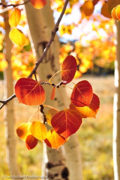
Fall Color in Southern Utah


A ridge coated in aspens near Brian Head, UT begins to turn color in the early fall. The view from the Markagunt Plateau is truly expansive; in the background are ranges and valleys in the Great Basin of western Utah, and on a clear day one can clearly see Wheeler Peak in eastern Nevada
Another autumn is upon us, and once again we find ourselves becoming familiar with the surroundings of a new home, this time in Southern Utah. Why this neck of the woods, with its famous expanses of colorful slickrock, isn’t more well known for fall color, I do not understand. Near Fish Lake is the largest single aspen colony in the world, which also happens to be the worlds heaviest known organism period.
A bit closer to home for us is the Markagunt Plateau, which reaches elevations of over 11,000 feet and contains expansive reaches of aspen that rival, and to be honest probably beat, any we experienced in Colorado. The weather has been fairly mild for the last month or so, with few storms and little wind, allowing the leaves to put on an extended show:

One of the unique features of the Markagunt Plateau are a number of expansive and recent (<10,000 years) lava flows that coat much of the landscape above 9000 feet. The stark lava flows provide a stunning backdrop for the brilliant fall colors that occupy pockets of soil within their midst.

Aspens and lava flows, Markagunt Plateau, UT

A beautiful grove of aspens on the Rattlesnake Creek Trail near Brian Head, UT. This trail has clearly been a popular route for quite some time; we found inscriptions on some of these aspens dating back to 1903! (Along with many more recent ones sadly…)
This pocket of trees near the Duck Creek Campground possessed the most vividly red leaves I’ve ever seen on aspen trees.

Golden aspens coat the flanks of Hancock Peak, a small cinder cone on the Markagunt Plateau. This view was obtained from the summit of Brian Head Peak, 11, 312 feet above sea level. In the distance is the western escarpment of the Paunsaugunt Plateau, home to Bryce Canyon National Park.

I pass this grove of aspens several times per week on my way to work. I had been keeping an eye on this particular tree for weeks, and on this foggy day I finally pulled the car over to snap a photo.
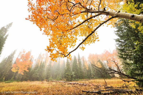
More aspens in the fog, Markagunt Plateau, Utah
A Sandstone Wonderland: Snow Canyon State Park


Thousands of moqui marbles, concretions of iron oxide minerals, accumulate in small troughs eroded into the Navajo Sandstone, Snow Canyon State Park, Utah
Southern Utah is a mecca for tourists from around the world, and most of that blame can be placed on the shoulders of a single layer of rock: the Navajo Sandstone. Quite possibly one of the most famous geological formations in the world, the Navajo Sandstone is responsible for the soaring cliffs of Zion National Park, the monoclines of Capital Reef, and the undulating, swirling, entrancing patterns of the The Wave in Arizona and Grand-Staircase Escalante National Monument in Utah. The Navajo Sandstone also rears its beautiful head in lesser known gems, such as Snow Canyon State Park just a few minutes northwest of St. George, Utah.
Snow Canyon is actually several canyons in one, all cut into the Navajo Sandstone. The original Snow Canyon existed up until about one million years ago, when it was rudely filled in by a series of basaltic lava flows originating from the northeast. Water, being the couch potato that it is, doesn’t like to carve through hard volcanic rock, so the stream that had excavated Snow Canyon promptly jumped ship to find some more Navajo Sandstone, and thus began establishing a new canyon slightly to the west. The stream went about its business carving Snow Canyon #2 until about 10,000-20,000 years ago, when it was thwarted by yet another lava flow. True to history, the stream changed course a second time, and is now busily carving Snow Canyon #3 even further to the west. The result is a multi-tiered canyon, with the remnants of the canyon-filling lava flows forming the tread of each step.

360 degree panorama of Snow Canyon State Park from the top of a “turtleback” of Navajo Sandstone, a small knob of rock that was surrounded by basaltic lava flows that diverged around it during eruptions 10,000-20,000 years ago. The small dark black patch just to the left of center is the entrance to a lava tube. The current iteration of Snow Canyon is seen at left.
The Navajo Sandstone itself is a colossal formation, several thousand feet thick in places, representing the lithified remains of a large Jurassic sand dune sea (known as an erg), likely analogous to the modern day Sahara desert. If you think Southern Utah is hot and dry today, imagine being there 180 million years ago when the climate was hot and hyper-arid. Add some dinosaurs and you’ve got yourself a fun day in the Jurassic desert. Over time, mineral-rich fluids percolated through the sand, depositing mineral cement in between the sand grains, binding them together into stone. The Navajo Sandstone is known for its spectacular aeolian (fancy geology-speak for “wind-blown”) cross-bedding, inclined layers that form when winds blow sand up the shallow face of a dune, only to have it tumble down the steep slip face on the other side.

Cross bedding in the Navajo Sandstone becomes even more pronounced as sunset nears and shadows lengthen

Looking south across swales and ridges of Navajo Sandstone from the Petrified Dunes trail in Snow Canyon State Park, Utah
A especially peculiar property of the Navajo Sandstone is the presence of occasional beds containing abundant spherical concretions of sand held together by the iron oxide minerals goethite and hematite (see photo at top of page). Commonly known as “moqui marbles,” these small spherules are slightly harder than the rest of the sandstone, so as the rock weathers away, the concretions are left behind to accumulate in large quantities on the surface of the rock. Moqui marbles can be found in many locations throughout Utah. And on Mars. The discovery of nearly identical hematite concretions by the Opportunity rover was some of the first definitive evidence that liquid water once flowed on the red planet, since the formation of the marbles requires groundwater to dissolve, and then re-precipitate iron minerals in the subsurface. If you are intrigued by my incredibly vague and simplistic description, you can find much, much more on the moqui marbles and their mode of formation here. If not, you are hereby forgiven and are welcome to enjoy the final photo without guilt:

Hematite rich beds in the Navajo Sandstone are more resistant to weathering & erosion, forming large brown, black, and red boulders that are scattered across the landscape
