The View from Above: Panoramas from Colorado’s Peaks

Why do we climb mountains? For the sheer physical challenge. For the adrenaline rush. For the smell of danger that accompanies looking over the edge into 2,000 feet of nothing but thin air. For the mental high that comes from conquering a summit. To temporarily escape from the chaos of humanity stewing below. “Because it is there”. Your answers may vary. I climb mountains for all of these reasons, with different ones taking priority depending on my mood (although I have a limit to how much danger I am willing to smell…). Ultimately though, as a photographer, I climb mountains for the view.
With the highest average elevation of any state, Colorado has no shortage of mountains, and thus no shortage of views. Some of the best come from the summits of Colorado’s famous 14ers, a group of 53 peaks whose crests reach to more that 14,000 feet above sea level. At this altitude, other than birds and oncoming thunderheads, there is nothing left to look UP at. No mightier peaks obstruct your gaze and if you’re lucky, you might even catch a glimpse of a plane flying a few thousand feet below.
However there is not a direct correlation between higher elevation and better views. Far from it. After all, the 14ers have done nothing special to earn their fame, they have simply been the recipient of enough geologic good fortune that their summits exceed the ultimately meaningless and arbitrary 14,000′ mark. As a result, the Mount of the Holy Cross, topping out at 14,009′, is one of Colorado’s most famous mountains, in large part due to those uppermost nine feet. Meanwhile, Grizzly Peak, just 14 feet lower (13,995′), lies nearly forgotten just a few dozen miles away (lost in the shuffle of six—that’s right six—different Grizzly Peak’s in the state) yet provides an equally majestic vantage point.
Below I’ve put together a collection of panoramas shot from different summits around the state in an attempt to present the diversity of Colorado’s mountain peaks. Every summit, no matter how high, has a distinct atmosphere and feel, from suburban hills where you can down onto sprawling subdivisions and strip malls, to remote wilderness peaks where the only sign of mankind might just be the jet contrail 15,000 feet above you. Seeing summit panoramas always encourages me to get outside and fight Earth’s gravity once again. So go find any good chunk of rock that sticks up a bit above its surroundings, walk, hike, bike, climb, or crawl up it, and you are sure to be rewarded. My only specific advice is to find a peak without a road to the top. Views are best enjoyed in solitude and few things as demoralizing than spending hours trudging up a mountain only to find a gift shop, parking lot, or a family of six enjoying a three course meal in the back of their hummer at the top…or worse, a combination of all three.

Mt Sneffels, San Juan Mountains, 14,158′

Mt. McConnel, Poudre Canyon, 8,008′

Twin Peaks, San Juan Mountains, 10,798′

North Baldy Peak, West Elk Mountains, 12,850′

Mt. Shavano, Sawatch Range, 14,236′

Crag Crest, Grand Mesa, 11,189′

Courthouse Mountain, San Juan Mountains, 12,152′

Mt. Elbert, Sawatch Range, 14,440′ (highest point in Rocky Mountains)
The grand old Rocky Mountains!

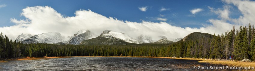
Clouds linger over the Continental Divide as seen from Bierstadt Lake
The grand old Rocky Mountains!
Their bold and massive forms,
Like Pyramids of age,
Defy the sweeping storms!
-Enos A. Mills, 1887
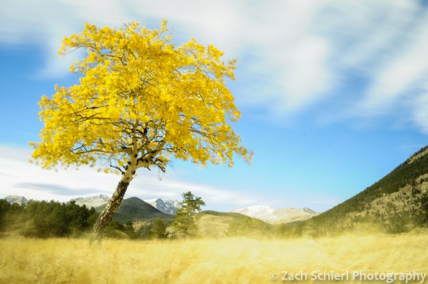
A hectic few months has kept me away from the website recently but fortunately not from my camera. My recent move to Fort Collins, CO means that my new backyard playground is Rocky Mountain National Park, only an hour from my doorstep and home to some truly spectacular scenery, especially in the fall when the aspens and willows turn golden and storms begin to dust the high alpine tundra with snow.

Fall colors along Bear Lake Road
My arrival in Fort Collins happened to coincide with the annual fall elk rut, in which bull elk gather large groups of females (called harems) together to mate. The many large grassy parks in RMNP are a popular gathering place for the elk and hundreds of people can be found lining the roads and trails skirting the meadows each evening to observe them in action. Even though I used to regularly see elk in our backyard growing up, this was a new experience for me. After an evening of watching and photographing the bull elk mate, lock antlers with other males, and toss back their heads to bugle, I can now confidently check “witness an elk rut” off my non-existent bucket list. I would share some of my photos of this unique spectacle, but in order to keep this website rated PG-13, I had better pass…

An elk cow shares a tender moment with her calf.
While snow starts to fall in the high Rockies in late September or early October, the weather usually remains pleasant well into October or even November. We’ve had a few storms the past few weeks that have dropped some not insignificant amounts of snow in the high country so every hike I’ve taken so far has been an exercise in scouting trails less likely to be covered in snow and ice.

The Loch Vale in Rocky Mountain National Park
Earlier this week I decided to hike to the base of the east face of Longs Peak and Chasm Lake. I was unsure if I would actually be able to make it to the lake given its 11,700 foot elevation but I had picked Chasm Lake because I had noticed that the last (and highest) mile of trail hugged a south facing slope. A south facing slope equals more direct sun and theoretically less snow. My scouting paid off; the trail was nearly snow free save for some hard packed, but easily traverse-able snow just above tree line and the final 200 yards to the lake. The final 200 yards presented a bit of a challenge: a 30 degree slope guarding the lake that was basically one gigantic ice rink. I wasn’t going to be getting up the main trail without crampons but thankfully, a series of rock ledges alongside the trail were solid and dry, providing an alternative route up the final 200 vertical feet to the lake with only a little Class 3 scrambling required. Upon finally reaching the lake, I was met by a wonderful late autumn scene and quite happy to have avoided the the colossal disappointment of hiking 4+ miles only to get turned around with only a few hundred yards to go.

The Ships Prow (left) and Longs Peak (14,259′, right) tower above Chasm Lake
The snow and ice had the added benefit of deterring the crowds that seem to linger in the park well into the fall. The previous week I had hiked to Loch Vale in a busier section of the park and just getting to the trailhead had involved being stuffed like sardines in a park shuttle bus. Chasm Lake though I had all to myself for over an hour, save for a pair of climbers descending from Longs Peak, the highest summit in the park. The east face of Longs Peak is an imposing sight, “abrupt and precipitous for three thousand feet” according to Enos A. Mills, an early resident of the area and the driving force behind the creation of Rocky Mountain National Park in 1915. The silence was stunning, save for the occasional high-pitched “eeeeeeeee” of a pika, the intermittent roar of the wind whipping up loose snow, and the din of fallen icicles and chunks of glacial ice crashing their way to the base of the cliffs.
At eve and morning lighted
With liquid gold all around,
Thy crests and hills and valleys
Gleam bright with glory crowned.
—Enos A. Mills, 1887
Aspen and grass waving in the wind in Horseshoe Park

Sunset and gibbous moon from Moraine Park
Speechless in the San Juans: A Day at Ice Lake

It’s no secret that I love mountains. It’s also not much of a secret that the San Juan Mountains of Colorado are my favorite mountains. I love the San Juans for a number of reasons. One of them is geology. Look at a map and its easy to lump the San Juans in with the rest of the Rockies, but geologically speaking, they’re a whole different ballgame. Formed not by uplift but by some of the largest and most violent volcanic eruptions in Earth’s history (think Yellowstone only MUCH, MUCH larger…), the San Juans have a personality all their own. They are tall (12 peaks above 14,000 and 314 above 13,000), large (more than 10,000 square miles, as opposed to the long but skinny ranges that dominate the rest of Colorado), and so steep that only three ski resorts exist here.
I also love the San Juans for the solitude they can offer. 5+ hours from major metropolitan areas (*cough*Denver*cough*), escaping the crowds here is much easier than in the rest of the state’s mountains (*cough*Aspen*cough*).
As of last weekend though, my number one reason to love the San Juans is that the San Juans contain Ice Lake, which might be the most beautiful location I’ve visited on Earth to date.

Ice Lake reflecting Vermillion Peak, Golden Horn, and Pilot Knob
Ice Lake is a glacial tarn located at 12,300 feet not too far from the mining town of Silverton. Fortunately, it’s one of the few major destinations in the San Juans that you can’t get anywhere close to with a jeep, which drastically limits the number of people that you see and the number of engines that you hear. Instead, it is accessed via a steep 3.5 mile hike from a trailhead along South Mineral Creek. It’s been on my list of places to go for several years now and my girlfriend Michelle and I recently got a chance to spend a few days in the San Juans and make the short but steep trek up to the lake. Hiking in Colorado’s high mountains in the summertime can be challenging. Near daily vicious afternoon thunderstorms make it hard to spend any appreciable time above tree line. Despite the fact that a good chunk of this hike was above treeline, we didn’t hit the trail until a little after 8am but fortunately the weather gods cooperated on this day.
While the scenery along the trail is spectacular, all is forgotten once you catch your first glimpse of Ice Lake. One look at the brilliant neon blue water and you suddenly feel as if you’ve been hiking through a prison yard for the last few hours. I’ve never seen water so vividly colored; some of the hot springs in Yellowstone are the only things that come even remotely close. The color is caused by the presence of “rock flour” in the lake, extremely fine sediment left over from the days when large glaciers scoured out Ice Lake Basin and ground the fragile volcanic rocks into a powder. These sediment particles are so small that they remain suspended in the water, scattering blue light toward the eyes of every astounded hiker and backpacker that reaches the basin.

Ice Lake (blue) and unnamed lake (green) with U.S. Grant Peak (13,767′) towering overhead.

Late afternoon clouds reflected in a small pond in Ice Lake Basin
Unlike many of the other high alpine basins in the San Juans, Ice Lake Basin is HUGE! Covering nearing five square kilometers, the basin contains several other named and unnamed lakes as well as some of the most impressive wildflower fields I have ever seen. White, red, pink, and yellow varieties of paintbrush, elephant ears, asters, and columbines blanketed the basin. Wildflower season in the lower elevations has long past but up at 12,000 the show is just reaching it’s zenith!

One of many colors of Paintbrush found in Ice Lake Basin.

Hey look! Colorado’s state flower, the Rocky Mountain Columbine!
Interestingly, the other lakes in the basin were not nearly as brilliantly colored, but rather a more drab blue-ish green that was nevertheless spectacular, especially when the wind calmed and the waters began to reflect the ring of peaks surrounding the basin. We lucked into a day where the thunderstorms had trouble developing and so we were able to spend 5-6 hours exploring the basin, crossing fields bursting with wildflowers, and relaxing by the lakes. We were hoping to get a glimpse of the mountain goats that often frequent such basins, but we had to settle for a handful of marmots and a trio of llamas which another party had used to pack their overnight gear into the basin.

Unnamed lake below Vermillion Peak (13,894′)

Golden Horn (13,769) reflected in Ice Lake.

Some of the views on the way up to Ice Lake. Here Corn Lily grows rampant in Lower Ice Lake Basin.
It’s not an exaggeration to say that this was one of the most beautiful landscapes I’ve ever seen. Walking through the basin, I was reminded of Robin Williams’ famous quip about Glacier National Park: “If this isn’t God’s backyard, then he certainly lives nearby.” Apparently God has now purchased a summer home in the San Juan Mountains because the scenery here is truly second to none.

Can’t remember ever being this sad about having to hike back to the car. Will have to come back and spend the night someday!
