Exploring the Earth and Sky of the West

Latest

Airglow: Denizen of the Dark Sky

I’ve been an astronomy nut ever since my parents gave me a small reflecting telescope for my 10th birthday. I located Saturn, complete with its too-good-to-be-true rings, within 10 minutes of setting it up for the first time, although my parents refused to believe me until they had a look for themselves. I majored in astronomy, own a telescope that barely fits in my car, and come to think of it, every “real” job I’ve ever had has involved astronomy. NASA’s Astronomy Picture of the Day has been my homepage for longer than I can remember.

Given my disposition towards both astronomy and photography, it seems superfluous to say that I’ve always enjoyed astrophotography.  Taking photographs of celestial objects presents a set of challenges not encountered by photographers who go home after the sun dips below the horizon, the majority of which revolve around the fact that most astronomical objects are rather dim, requiring long exposure times and extra equipment to capture.

Quite frequently I’ll get asked if I’ve ever seen any UFOs while gazing up at the sky. My standard response is that, while I’ve certainly seen a lot of weird *#&@ in the sky, I’ve yet to see anything that didn’t ultimately have a logical explanation, even if it took a little head-scratching to figure it out (high altitude weather balloons are the worst!).

A prime example of this occurred this past summer during a nighttime observing and photography session. I was attempting to get a 180 degree panorama of our home galaxy, the Milky Way, stretching across the summer night sky. I had my camera mounted on a tripod head that compensates for the rotation of the Earth, allowing me to take exposures several minutes in length while avoiding star trails in my images. It was dark and clear enough that I was able to get some good shots of the summer Milky Way and its complex and sinuous inky-black interstellar dust lanes, as well as some decent shots of some galaxies and nebulae through a telescope:

MIlkyWayThe Milky Way in the constellations of Scorpius and Sagittarius. This portion of the Milky Way is home to the nucleus of our galaxy, making the Milky Way appear brighter here than anywhere else in the sky.

Lagoon_NebulaThe Lagoon Nebula, also known as M8, a vast cloud of hydrogen gas giving birth to new stars. A “stellar nursery” as astronomers like to say.

While my shots of the galactic center in the southern sky were turning out well, as I began to pan my camera around to the east and then finally north, I noticed that faint but noticeable bands of diffuse red and green light were creeping into my image.

DSC_2917

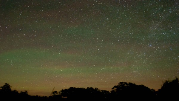
My immediate thought was sensor noise. The CCD chip on my old DSLR (a Nikon D70) had a habit of heating up during repeated long-exposures. This thermal radiation from the sensor manifested itself as a bright purple/pink haze occupying one corner of the photo, making any attempt at serious astrophotography futile. Perhaps something similar was happening here. I quickly ruled this out for a number of reasons. Most importantly, the apparition was showing itself only in photos taken towards the north, meaning that the source couldn’t be the camera, but rather something in the sky itself. The colors ruled out high clouds, and it wasn’t in the proper direction to be the result of artificial light pollution. The closest city of any significant size to the northeast was several hundred miles away.

Whatever it was, neither myself or any of my observing companions could see it with the naked eye.  A bit eerie perhaps, but not at all uncommon. Many astronomical phenomenon are too faint to see without long-exposure photographs. In fact, the first time I saw the aurora borealis, I captured it with my camera several hours before it became bright enough to see with the naked eye.

A auroral display was actually my second thought. What I was seeing in my photos definitely resembled one. Red and green are the colors produced by nitrogen and oxygen, the two primary components of our atmosphere, after being excited by collisions with magnetic particles brought to Earth by the solar wind. Most auroral displays consist of some combination of these two colors and what I was photographing appeared only in the northern sky which fit the theory to a tee.  Furthermore, the Sun had been especially active in the week or so prior. It was perfect except for one slight problem: I was in Colorado.

Auroras in Colorado are definitely not unheard of….but not exactly common either. One thing was certain: if an aurora HAD crept this far south, then the northern portions of the country would simultaneously be getting the show of a lifetime. A quick check of spaceweather.com, the one stop shop for up-to-the minute aurora information, showed this was not the case. Strike two.

I actually didn’t figure this one out until many days later, when I inadvertently ran across an article about some Pacific Northwest photographers who had captured something called “airglow” in some photos of the Milky Way taken at Mt. Rainier around the same time. A momentary glance at their photos and I knew I had my answer.

Milky_Way_Pano

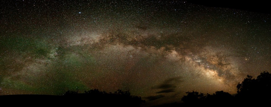
Here’s the final panorama I produced. The airglow (red and green splotches at left) was changing rapidly enough that it caused major headaches trying to stitch the images together. Consequently I didn’t quite get my 180 degree panorama, there’s a bit missing on the northern end (lower left).

Airglow is exactly what it sounds like (a rare thing in science, I know…): glowing air. Incoming solar radiation and cosmic rays ionize oxygen and nitrogen atoms in our atmosphere during the day and then then these atoms regain their electrons at night, emitting light in the process. This is similar to what happens during an aurora, except that it’s happening ALL THE TIME. Airglow is always there, it’s just really, really faint; you need to be somewhere extremely dark to have a chance of seeing it, even with a camera. Even a miniscule amount of light pollution will render it invisible. It does tend to be brighter when solar activity is high, although it is not nearly as dependent on the solar cycle as its brighter cousin, the aurora.

So what began as an unidentified and undesirable annoyance in my photos (and when trying to stitch together my panorama, boy it sure was!) turned out to be a rarely captured celestial phenomenon I had never even heard of, much less one that I had intended on photographing that evening.  Next time someone asks me about UFOs, I’ll just refer them to this page.

Larch Hunting in the North Cascades

DSC_7015

Golden Larches at Blue Lake in the North Cascades.

Still reeling from the disappointment of having to leave Colorado a mere fortnight before the world’s largest Aspen forests exploded into their annual displays of color, I was determined to find some similar photo opportunities in Washington this fall.  The “Aspen of the Pacific Northwest” is arguably the Western Larch. Most common in the Northern Rockies, a handful of Western Larch stands can be found east of the Cascade Crest in Washington state. Tall but unassuming for 50 weeks out of the year, and then drop-dead spectacular for two, the Western Larch looks all for the world like an evergreen, but it is decidedly deciduous. Most high-altitude Pacific Northwest forests are all evergreen, so unless seeing dead and decaying brown pine-needles pile up on the forest floor is your thing, autumn up in the high Cascades isn’t anything to get too excited about. Add larch though and it’s a different story. The yellowish-green needles of the larch go out with a bang, turning a glittering golden-yellow for just a few short weeks in the late fall before leaving the tree buck naked until the following spring.

DSC_7119

DSC_7006

Golden larch season in the Cascades is an event that generally attracts hordes of needle-peeping Seattleites to the mountains. My hope was that the several feet of early-season snow the mountains had received in late September would be deep enough to temper the crowds. I was wrong. The parking lot at the Blue Lake Trailhead off of Highway 20 in the Okanogan National Forest was completely full, forcing us to park alongside the highway. Fortunately, photographers are born with an innate desire to bask in late-afternoon light which meant we were headed up the trail to Blue Lake late enough that most other folks were already on their way down. One advantage to having lots of folks on the trail was that we were alerted to the presence of a solitary mountain goat scrambling along a rocky gully a few hundred feet above the trail.

The lower portion of the trail was snow-free, but by the time we reached the goat and the larch groves, it was several feet deep. The main trail was hard-packed snow and ice due to all of the foot traffic but wandering off trail trying to take pictures of the larches sans people would definitely have been easier with a pair of snowshoes. The larches were nothing short of spectacular, especially against the snowy-white backdrop.  In the late afternoon sun, the color of the needles was so resplendent that you could have painstakingly coated each needle in gold leaf and not known the difference. Individual larches on mountain ridges miles away could easily be picked out, their needles back lit by the sun, shining like beacons in a sea of mountains.

DSC_7109

A surprisingly sunny and warm October afternoon in the North Cascades is perfect for larch hunting.

DSC_7053

Exploring off trail, gazing out at the Cascades through the larches.

Later in the evening, headed to a lower-elevation (read: warmer) camping spot, I was able to catch the very last rays of sunlight on Liberty Bell Mountain. And just in case larches and a spectacular sunset weren’t enough, the clear skies and nearly full moon were ideal conditions for some nightscapes of the North Cascades!

DSC_7168

Sunset along the North Cascade Highway.

DSC_7185

The constellation of Aquila sets over North Cascade peaks illuminated by the Full Moon .

Rails Vanquished, Rails Reclaimed: Hiking the Iron Goat Trail

Driving west on Highway 2 over Stevens Pass last spring, I kept catching glances of what appeared to be some sort of elongate, dark grey, overgrown, man-made structure paralleling the highway on the opposite site of the Tye River valley. Whatever it was, only isolated chunks of it were visible through the dense vegetation and the deep, late-season snowpack. It appeared to me to be made of concrete, although it was hard to be 100% sure given that my primary goal at the time was to prevent a van full of people from careening off the highway and plummeting into the gorge below. Ironically, little did I know that the very existence of the mysterious object I was seeing was the result of a passenger train carrying hundreds of people doing exactly that 113 years earlier.

The largest concrete snowshed on the Iron Goat TrailWalking through a large concrete snowshed along the Iron Goat Trail, built at the site of the 1910 Wellington disaster to prevent future avalanches from sweeping trains and passengers off the rails.

The logo of the Great Northern Railway at the Iron Goat Trailhead

It didn’t take long after getting home to my internet connection to figure out that what I was seeing was the old grade of the Great Northern Railway, the northernmost of the transcontinental railway routes in the U.S. The Great Northern reached Seattle in 1893 and the route it took across the Cascades can best be described as “gnarly”. A series of extremely steep switchbacks, and eventually a 2.60 mile long tunnel completed in 1900, funneled trains safely, if not easily, over Stevens Pass to Seattle. In the summer at least. The biggest danger of the route lay in the combination of heavy winter snows and steep rugged topography. The railway built a number of snowsheds, large concrete or timber structures which covered the rails in avalanche prone areas to protect the locomotives. Avalanches don’t always play nicely though, and in March of 1910, during a storm in which 11 feet of snow fell in one day, a 10′ thick slab of snow detached from Windy Mountain several hundred feet above the tracks and swept two trains off the tracks just outside the railroad town of Wellington, Washington. 96 people perished in what remains the deadliest avalanche in U.S. history, and one of the worst railroad disasters in the country’s history to boot.

Despite the somber backstory, the old railroad grade has been turned into what has to be one of the most fascinating hiking trails in Washington: the Iron Goat Trail. Taking its name from the mountain goat on the logo of the Great Northern Railway, the Iron Goat trail follows the portion of the railroad grade that was abandoned in 1929 after the 8-mile long Cascade Tunnel (still in use by the BNSF today) opened, which for the first time allowed trains to bypass the pass and its deadly avalanche chutes entirely.

The west entrance to the Windy Point Tunnel

Looking into the abandoned Windy Point Tunnel along the Iron Goat Trail

While this hike may not provide a wilderness experience (Highway 2 and the associated drone of motor vehicles is just a stone’s throw away across the valley), it does provide a heavy dose of history and just enough eeriness to keep you from ever wanting to spend the night. In between the Wellington disaster and the opening of the Cascade Tunnel, a span of just 19 years, the Great Northern Railway heavily fortified the section of rails near Stevens Pass in an attempt to prevent another disaster. I hiked the four mile section of the trail from Highway 2 to the Wellington Townsite and nearly the entire stretch was engineered in some way: tunnels, timber snowsheds, concrete snowsheds, you name it, the Great Northern Railway spared no expense in attempting to tame the mountains and make this a viable travel route over the Cascades. They even gave the town of Wellington a new name, “Tye”, because of all the bad publicity. Ultimately though, the mountains emerged victorious: the line was abandoned in favor of the tunnel less than 30 years after it was first constructed, leaving the man-made structures built in response to the Wellington disaster to slowly decay and become re-assimilated into the mountain.

This process is already well underway. After decades of enduring heavy winter snows, timber snowsheds are now unrecognizable piles of rotting wood. Concrete snowsheds are crumbling, exposing their innards in a scene that my hiking partners likened to the post-apocalyptic visuals of the Hunger Games.

A concrete snowshed falls into disrepair along the Iron Goat TrailDeep snow and avalanches ultimately get the better of anything man builds to lessen their impact

Many of the tunnels have partially collapsed, including the Old Cascade Tunnel, the longest in the world when it opened at the beginning of the 20th Century. In 2007, a portion of the roof collapsed, creating an unstable dam of debris which occasionally likes to rupture and send a deadly torrent of water rushing out the west end of the tunnel without warning. The Windy Point Tunnel, built to keep trains from derailing around a particularly sharp curve, is also slowly crumbling away while the entrances are slowly reclaimed by the forest:

Entrance to Windy Point Tunnel on the Iron Goat Trail

Moss and debris slowly reclaims the old grade of the Great Northern railway at the entrance to the Windy Point Tunnel

A rockfall along the Windy Point Tunnel is the backdrop for some fall foliage

Portions of the Windy Point Tunnel have been heavily damaged by rockfall. Thankfully, Gary and the fall foliage escaped unscathed.

After a somewhat strenuous 700 foot climb from the trailhead up to the Windy Point Tunnel, the hike follows the gentle grade of the old rail bed for several miles in either direction. Thanks to impressive work by local volunteer groups, the trail is well-maintained and a series of interpretive signs explain the history of the Great Northern Railroad and the chain of events that led to the Wellington disaster. Several spots on the trail have great views of the Tye River valley and the surrounding peaks in the Cascades making for a beautiful, intriguing, and incredibly diverse hike. But stay away during the winter for obvious reasons, and like I said, not really somewhere you’d want to spend the night…

Interesting graffiti in one of the snowsheds

Fun graffiti inside the concrete snowshed

For more info, trail maps, and directions, check out http://www.irongoat.org/