Europe Part 4: Sarajevo and Mostar

Links to previous posts: Part 1, Part 2, Part 3
A short 45 minute flight on Croatia Airlines took us to Sarajevo, the capital and largest city of Bosnia and Herzegovina. We arrived around midnight and hailed a taxi from the airport to our lodging in the city center. I was immediately glad to not be piloting a rental car here! Even as the clock approached midnight, the taxi ride was…shall we say…exciting; hilly terrain, pedestrians at every turn, lots of traffic sharing the road with rumbling communist-era trams, and sidewalks seemingly used as an extension of roads and parking lots.
Chaotic start aside, Sarajevo ended up being one of our favorite stops on the entire trip. There is so much complex and fascinating history packed into this relatively small city. Sarajevo has been a meeting point of cultures and a model of religious tolerance for hundreds of years. Ironically and sadly, the city is perhaps best known for two darker moments: the assassination that sparked World War I, and a tragic four-year siege in the early 1990s during Bosnia’s war for independence from Yugoslavia.

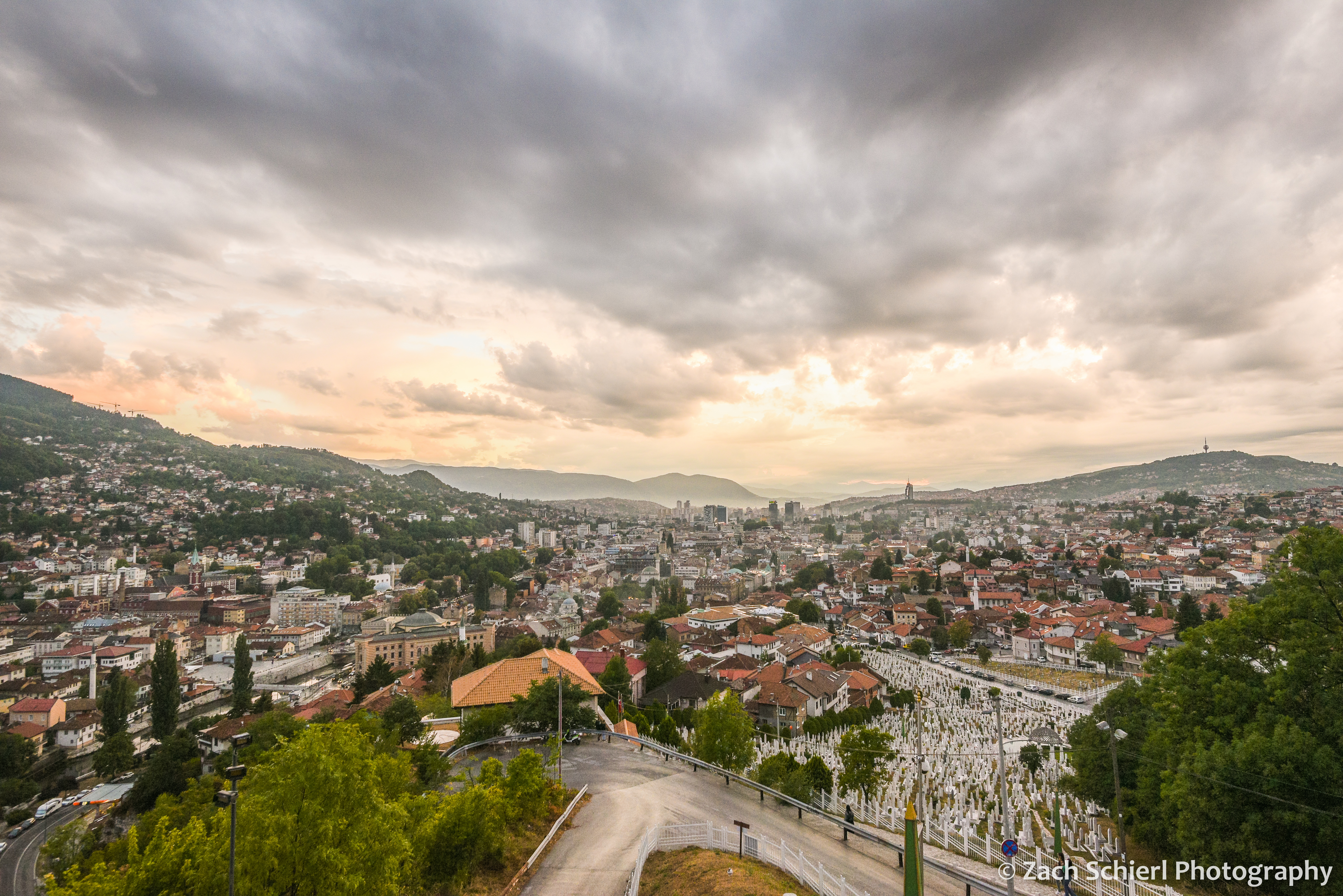
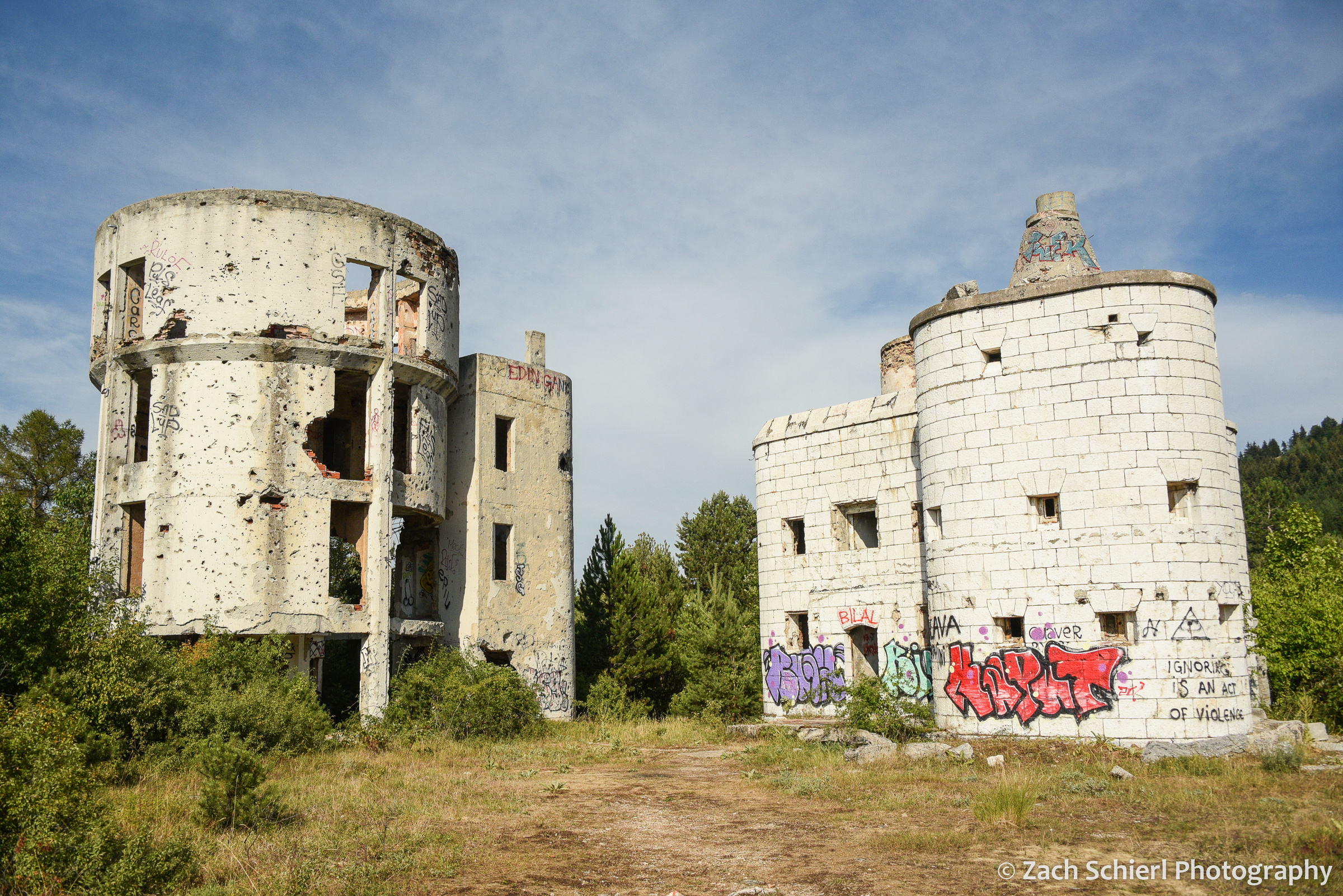
More on the history later, but the first thing that struck us when we looked out the window the following morning was that Sarajevo is situated in an absolutely gorgeous landscape. It’s one of the few cities I can recall that seems to complement the natural landscape rather than detract from it. The bulk of the city is confined to a long, narrow valley that slices through the Dinaric Alps, with the Miljacka River winding along its bottom. Mt. Trebević rises more than a thousand feet above the city to the south, while other hills bound the valley immediately to the north and east. While this makes for gorgeous scenery, the unique geography was what allowed the Bosnian Serb Army to besiege and terrorize residents of Sarajevo from 1992 to 1996. One prominent casualty of the siege is the bobsled track used in the 1984 Winter Olympics, located on the slopes of Trebević above town. The track was used as fortification during the war and is now abandoned, as are the shelled out remains of the Čolina Kapa Astronomical Observatory (the only professional observatory in Bosnia) nearby. We took the recently (2018) rebuilt cable car to the top of Trebević to get a bird’s eye view of Sarajevo and then enjoyed a pleasant, though at times eerie, hike back down into town, past the crumbling, graffiti covered bobsled track and through several residential neighborhoods perched above the main city.

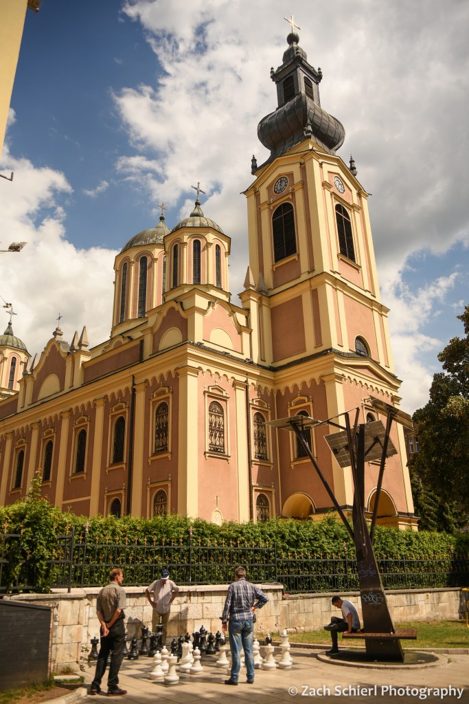
Today, Sarajevo (and Bosnia itself) is majority Muslim. Half a dozen mosques, with their pointy minarets, are visible from just about any point in town, and the city is punctuated with the sounds of the Adhan (Muslim call to prayer) issuing from the minaret loudspeakers five times a day. Interspersed among the mosques are several Catholic cathedral spires, eastern Orthodox churches, and a Jewish synagogue, indicative of how people of many faiths have converged and lived together peacefully in Sarajevo throughout most of its history.
At the east end of Sarajevo is the Baščaršija, the “old town” with architecture dating from the era when Bosnia was part of the Ottoman Empire. The tiled roofs, narrow lanes, and bazaars seem transported here from Turkey or the Middle East.


West of the Baščaršija is a newer section of town with buildings resembling those in Ljubljana, built during the late 1800s when Bosnia was part of Austria-Hungary. Speaking of Austria-Hungary, the heir to that throne, Archduke Franz Ferdinand, was on an official visit to Sarajevo in 1914 when he was assassinated by a Serbian separatist on a non-descript street corner along the Miljacka River. Austria-Hungary demanded that Serbia investigate the assassination, and when they refused, Austria-Hungary declared war on Serbia, triggering alliances that plunged the globe into World War I. The site today is home to a small museum and marked by a a plaque and metal plates showing where Ferdinand’s convertible was stopped during the shooting.
Even further west is the modern business and government district, with its large hotels, skyscrapers, shopping malls, and lots of traffic. It is also home to the U.S. Embassy, which appeared to be better fortified than the Bosnian parliament building across the street. We explored this area a bit on our final morning in Sarajevo, on our way to the nearby train station. After a short ride on one one of the extremely rickety but charismatic communist-era trams, we took the elevator up to the 35th floor of the Avaz Twist Tower skyscraper for an aerial view of the city.

We ended up spending almost an entire day with a local guide, journalist, and siege veteran, Amir Telibećirović, who wove a powerful narrative of Bosnian history, from ancient times up through the present day, while walking with us around town to visit a variety of sights. Especially striking were the many small cemeteries containing hundreds of white headstones from the siege. These cemeteries were located right in the middle of town, in strategic locations where the risk of sniper fire was minimized. Even then, residents typically waited to conduct burials during periods of heavy fog. While Sarajevo is a bustling city filled with tourists today, the scars of war are still quite obvious here, more so than anywhere else on our journey through the former Yugoslavia. Many buildings remain riddled with holes from shrapnel and bullets, especially if you stray away from the main tourist destinations. And beyond building facades, Bosnia’s economy has been slow to recover and unemployment remains quite high compared to other Balkan countries.
In addition to soaking up the local history, we also spent a fair amount of time soaking up calories by trying the many delicious local foods, including strong Bosnian coffee, burek (filo dough rolls stuffed with meat, cheeses, potatoes, etc) and Ćevapi (little sausages in pita-like bread with a creamy cheese called kajmak). All very tasty, and all very meaty. We frequently remarked on how it would be hard to be a vegetarian in Bosnia! Another highlight was sunset from atop an old fortification called the Yellow Fortress. From here we had a spectacular view looking west down the Miljacka River valley toward the setting sun. With residual clouds from a series of brief thunderstorms earlier in the day, the lighting was truly spectacular, and combined with the illuminated mosques and call to prayer, it made for a very unique and memorable experience.

After several days in Sarajevo, we boarded a train and headed south to Mostar. We were once again reminded of the ease and comfort of European train travel. (It’s a damn shame this mode of transportation isn’t more viable in the U.S.) As we rolled through the scenic mountains of Bosnia, the vegetation changed gradually, from the relatively verdant landscape near Sarajevo to a more desert-like, Mediterranean landscape as we neared Mostar.
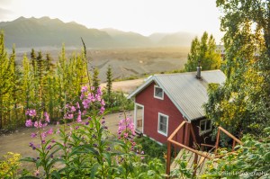
From the train station in Mostar, it was a twenty minute walk to our hotel for the evening. It was getting close to sunset so we made a quick detour to see the primary attraction of Mostar: Stari Most (the “Old Bridge”). The Old Bridge is, not surprisingly, a bridge spanning the Neretva River, connecting the east and west halves of Mostar. It is not, however, very old. The bridge was originally built in the 1500s but was sadly destroyed during the Bosnian war in the early 1990s, along with much of Mostar. Today’s bridge was rebuilt in the early 2000s, using the same techniques, tools, and materials used in the original version. Shops and restaurants line the cliffs along the river on either side of the bridge, and it was PACKED! We had a somewhat forgettable dinner in an unforgettable setting on the banks of the river with a beautiful view of the bridge and city.

Mostar was a brief stop en route to the Adriatic coast, so we unfortunately didn’t have much time to explore beyond the main sights. After less than 24 hours, we were walking back to the train station to catch a bus to Dubrovnik, an experience that turned out to be the polar opposite of our train journeys in just about every way possible. That’s next time!

Europe Part 3: A Cavalcade of Capitals

After starting off our trip with a foray through the mountains, the next leg was decidedly more urban as we toured a trio of capital cities: Ljubljana, Zagreb, and Sarajevo.
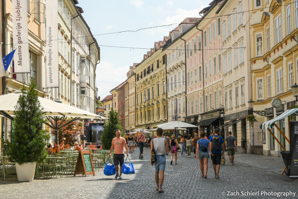
After returning our rental car at the Ljubljana Airport, we took a shuttle into the city center. Ljubljana, the capital of Slovenia, is relatively small for a European capital, with just a few hundred thousand residents. The city was heavily damaged during a large earthquake in 1895. At the time, Slovenia was part of the Austro-Hungarian Empire, so many of the buildings in the city center were rebuilt in the same architectural style prominent in cities like Prague and Vienna. For the last decade or so, the center of Ljubljana has been set aside as a pedestrian zone…no cars allowed! We enjoyed our limited time in town strolling the wonderfully car-free streets, crisscrossing the many bridges over the Ljubljanica River, and riding the funicular up to the castle that overlooks the old town. The highlight was a food and wine tour with a local guide and wine expert who introduced us to a variety of foods and wines from different regions of Slovenia: deep fried sardines from the Adriatic coast, homemade meats and cheeses from the Hungarian-influenced northeast, Carniolan sausages and barley stew from the southwest, and a delicious layered dessert with dumpling, nuts, raisin, breadcrumbs, and creamy cheese.

We also learned more about life in Slovenia and the recent history of the area from our guide. Most of the countries on our trip were part of the former communist republic of Yugoslavia. Slovenia was the first to declare independence in 1991 and fortunately did not experience the brutal conflicts that followed independence declarations in neighboring Croatia and Bosnia. Talking to our guide, we learned that Slovenia’s education system is well-funded, pre-K childcare costs only a little over $100/month, college and housing are relatively affordable, and new mothers are guaranteed a year of paid maternity leave. As a country, Slovenia also seems to be more environmentally conscious that most. After a week in Slovenia, we left with the impression that this is a progressive country that cares about making life better for its residents. What a concept!

Ljubljana was one of many stops where we wished we could stay longer, but after about 24 hours, we were on one of the few train journeys of our trip to Zagreb, the capital and largest city of Croatia. Zagreb is much larger than Ljubljana, with roughly one million inhabitants, and the difference was noticeable from the moment we stepped off the train. The overall atmosphere of Zagreb felt like a much larger, faster paced urban center compared to the relative tranquility of Ljubljana.
Most of Zagreb is relatively young by European standards, with much of the city center built up over just the past 150 years. (Quite a few buildings, including all of the major cathedrals, were in scaffolding during our visit, still under repair from damage incurred during a major earthquake in March 2020.) Our room for the night was in the small “old town” section of Zagreb, which consists of two adjacent hills with buildings dating back to the 1500s. At odds with one another for most of history, these two towns officially merged in the 1850s, leading to the creation of the greater Zagreb that exists today.
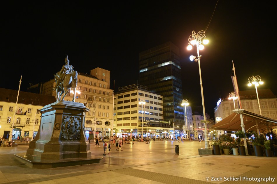
Like all of the cities we visited on this trip, Zagreb was bumping. We never ceased to be amazed by how many people (tourists and locals alike) were out and about late into the evening, regardless of whether it was a Tuesday, Thursday, or Saturday. Sitting on Jelačić Square (the central social and transportation hub of Zagreb, pictured above) late at night, watching a steady stream of electric trams whisk people back to all parts of the city, definitely made us reflect on how the U.S. cities we’ve lived in are built so differently.
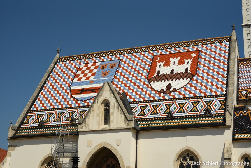
Our time in Zagreb was also limited, so the following morning we took a free walking tour to get our bearings. At the top of the town was St. Marks Church, with its unique roof covered in colorful tiles depicting the coat of arms of Croatia (left) and the city of Zagreb (right):
In the afternoon, we took another walking tour focusing on the war for Croatia’s independence in the early 1990s. The events that led to this war (and the others in the Balkans around the same time) are, of course, incredibly complex and require a good understanding of history going all the way back to at least World War I to truly understand. While summarizing this history is not really within the scope or intent of this photography blog, I will say that it was absolutely fascinating to hear the varying perspectives on these conflicts via museums, tours, and conversations in several different countries. On our tour in Zagreb, we walked through some of the underground tunnels and bunkers that were originally built during WWII and then used again as bomb shelters during the recent war. Today, many of these tunnels remain in use as “shortcuts” for residents to get from one part of the city to another. (As an added bonus, it was a solid 30 degrees cooler down there than on the surface!)
Ultimately, I didn’t take a ton of photos in Zagreb or Ljubljana. Both cities were at their best after nightfall, and I definitely could have used a tripod. Many of the night scenes I photographed turned out rather blurry. From Zagreb we caught a short, late evening flight to Sarajevo which ended up being one of the highlights of our trip and will get its own post next time!
Alaska (Part Two)


Exploring the Root Glacier, Wrangell-St. Elias National Park & Preserve, Alaska
The second stop on our Alaska trip of 2019 was Wrangell-St. Elias National Park & Preserve. The largest national park in the United States, Wrangell-St. Elias spans more than 13 million acres in the wilderness of southeast Alaska. Our destination was the old mining town of Kennecott, situated deep in the park’s interior between the volcanic Wrangell Mountains and the coastal St. Elias Range.
Due to the tire issues mentioned in my last post, we opted not to take our Subaru down the 60-mile long McCarthy Road, the main access route into the park. In hindsight, we probably would have been fine, as the road was in excellent condition (at least relative to the roads we’d been used to driving in Utah. The similar-in-length Hole in the Rock Road makes the McCarthy Road look like a recently-paved superhighway). Fortunately, we were able to book a last minute van shuttle from Kenny Lake, AK to the end of the McCarthy Road. Regardless of your mode of transportation, you then walk across a footbridge spanning the glacial silt-laden Kennicott River into the town of McCarthy. (The only vehicle access to McCarthy is via a private, and very expensive, bridge a bit further downstream.) Kennecott is another 5 uphill miles by shuttle, bike, or foot:

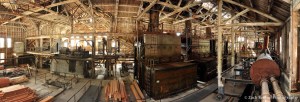
Kennecott, Alaska. The 14-story wooden concentration mill is seen in the background.
Strangely, reaching Kennecott would have been much easier in 1919 than it was in 2019. The McCarthy “Road” is actually an old railroad grade originally built in 1909 to bring supplies in and ore out of the famous Kennecott Copper Mines. From 1911 through the late 1930s, the Kennecott mines shipped millions of tons of copper ore to Cordova on the Alaska coast via the Copper River and Northwestern Railway. The town had state of the art amenities at the time, including one of the best hospitals in the territory as well as the first X-ray machine in Alaska. While the mines closed in 1938, Kennecott Copper remains one of the larger copper-producing companies in the world, perhaps best known for the massive Bingham Canyon Mine just outside of Salt Lake City.
Following the closure of the mines, Kennecott lay mostly deserted for decades before beginning to draw tourists in the 1980s. Much of the land and buildings within the town were acquired by the National Park Service in 1998 and added to Wrangell-St. Elias National Park and Preserve. Restoration and stabilization of historic buildings in Kennecott is ongoing. Today, you can actually explore many of these buildings, including the town power plant (photo below) and the massive concentration mill (photo above), a 14-story wooden structure where copper ore was crushed and then mechanically and chemically concentrated into the high grade ore that was eventually shipped out via the railroad.
The interior of the Kennecott Power Plant, with massive boilers used to produce electricity and steam heat for the mines and town residents.
History aside, the natural landscape of Kennecott is really what makes it stand out as one of the most stunning places I’ve ever visited. The town is perched on the flanks of Bonanza Ridge, with rocky peaks towering more than 4,000 feet above and what remains of the Kennicott Glacier below. At first glance, it is not apparent (even to a geologist) that the mounds of rubble in the valley below ARE a glacier, but ice does lay beneath the veneer of debris. Like most of the world’s alpine glaciers, the Kennicott Glacier has retreated dramatically since the town’s heyday in the early 1900s, when its surface was level with or even above the elevation of the town. Today, you look down several hundred feet on to what remains of the glacier and the detritus it has brought with it out of the mountains. The origin of the glacier, and the dominant feature of the northern skyline, is the massive Mt. Blackburn, the fifth highest peak on the United States at 16,391 feet:

Old mining buildings in Kennecott cling to the slopes above the debris-covered Kennicott Glacier, which originates on the slopes of Mt. Blackburn, seen in the background.
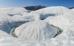
A few miles north of Kennecott, the Kennecott Glacier is joined by the Root Glacier, a somewhat more “normal” looking glacier that we spent nearly an entire day exploring. The experience was rather surreal given that the air temperature was nearly 90 degrees. Climates amenable to the formation of glaciers don’t often produce days where a swim in the frigid glacial melt water actually sounds appealing as opposed to horrifying, but that was certainly the case on this day.
As spectacular as the glacier was, there is something quite unsettling about walking around on one in a T-shirt. The signs and symptoms of a warming climate were all encompassing. We walked along deep gouges (surprisingly reminiscent of Utah slot canyons) carved into the ice by strong currents of melt water…

The Root Glacier, Wrangell-St. Elias National Park and Preserve, Alaska

The Root Glacier, Wrangell-St. Elias National Park and Preserve, Alaska
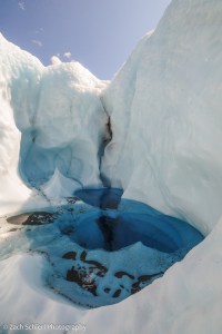
encountered many sublime pools filled with deep, electric blue pools of glacial melt water…
The Root Glacier, Wrangell-St. Elias National Park and Preserve, Alaska
and carefully avoided deep shafts, known as moulins, that carry cascades of melt water into the internal plumbing of the glacier. In many places, we could hear the dull roar of the melt water boring tunnels through the ice beneath our feet. Glaciers like Root won’t survive many more summers with too many days like this one.
Meander in a meltwater channel, Root Glacier, Wrangell-St. Elias National Park and Preserve, Alaska

Patterns of sediment in the ice, Root Glacier, Wrangell-St. Elias National Park and Preserve, Alaska
Despite the best efforts of the interpretive signs displaying historical photographs, and the park film showing the sights and sounds of the past, the sheer remoteness of Kennecott in 2019 makes it difficult to imagine the Kennecott of 1919: a busy town immersed in the deafening roar of copper mining, with a glacier not yet ravaged by climate change dominating the horizon.
Clusters of fireweed overlooking the Kennicott Glacier, Wrangell-St. Elias National Park & Preserve, Alaska
