Exploring the Earth and Sky of the West

Latest

Fun in the Fort Collins Foothills

Horsetooth Rock

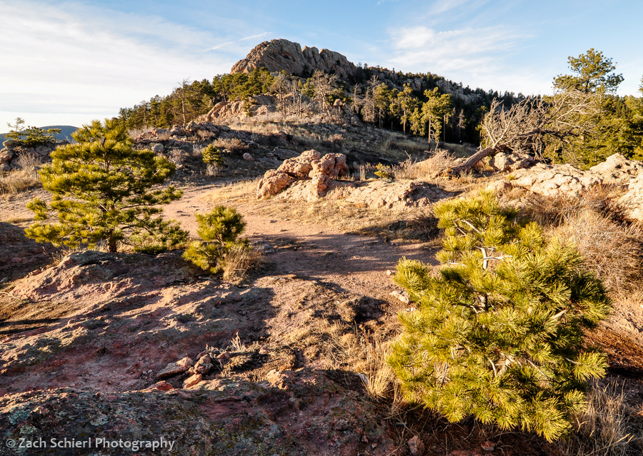
Horsetooth Rock, a famous Fort Collins landmark, is composed of hard Precambrian pegmatite.

It is currently snowing so hard I can barely see across the street. Fortunately, I haven’t been able to say this very often this winter, and I strongly suspect it won’t even be true 10 minutes from now. After six winters in the Pacific Northwest, once again residing somewhere where “warm” and “dry” are not mutually exclusive weather conditions has been quite refreshing. The mild weather has made hiking and all the other outdoorsy things that are practically a prerequisite for obtaining a Colorado driver’s license quite enjoyable. I’ve written about some of my adventures up to Rocky Mountain National Park but have yet to share any photos of our more immediate surroundings here in Fort Collins.

Fort Collins itself, lying at the extreme western edge of the Great Plains, is…well…flat. The only sledding hill I’ve yet seen here is a pathetic 20 foot run down the side of a large pile of gravel in the corner of the college football stadium parking lot. (As you’ll notice though, there is very little snow in any of these photos, so this is sort of a moot point.) Immediately west of town though lie the foothills of the Rocky Mountains, a beautiful landscape of ridges and valleys that mark the boundary between the plains and the Rockies.

Fort Collins at sunset

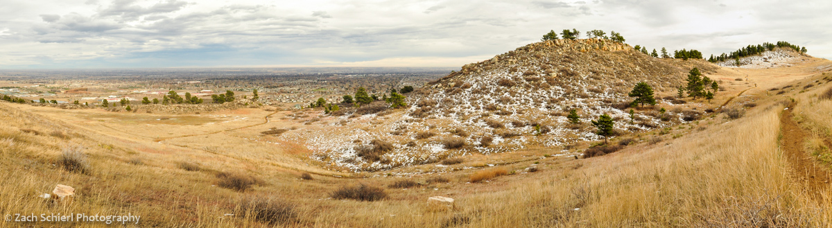
Overlooking Fort Collins just before sunset from cuestas (ridges) between town and Horsetooth Reservoir.

Lichens on sandstone boulders

Colorful lichens coating sandstone ledges of the Cretaceous-age Lytle Formation, Coyote Ridge Natural Area.

Geologically speaking, the foothills are fascinating (though geologists find just about any landscape fascinating…heck even Iowa has one of the largest asteroid impact craters on Earth lurking just beneath its surface) because they  represent where the Rocky Mountains pushed their way up through the crust. Prior to the uplift of the Rockies, this portion of Colorado was covered in a thick, continuous stack of colorful but more or less flat-lying sedimentary rock layers, much like one sees at the Grand Canyon today. Eventually, the Rockies thrust their way upward through the sedimentary rock, forcing the formerly flat layers to tilt toward the east. Over time, the softer sedimentary layers were (relatively) easily eroded away, forming long north/south trending valleys. Other layers were harder and resistant to erosion, forming dramatic sloping ridges known as cuestas and hogbacks that parallel the valleys.

The resulting pattern of alternating ridges and valleys is striking and has practical uses as well. In many places, streams flowing out of the mountains have been dammed at the point where they slice through the ridges, forming long, slender reservoirs that flood the valley bottoms. Horsetooth Reservoir, which provides some drinking water for Ft. Collins and irrigation water for the plains, is perhaps the best example.

Devils Backbone hogback

Devils Backbone, a nearly vertical hogback of Dakota Sandstone south of Fort Collins.

Slightly further west, the landscape changes as the sedimentary layers give way to the igneous and metamorphic rocks that compose the bulk of the Rockies, forming famous local landmarks such as Horsetooth Rock (above) and Arthur’s Rock.

The plethora of city, state, and county parks that protect large swaths of the foothills are increasingly important as the cities below the foothills encroach on wildlife habitat. Mammals like deer, elk, bobcat, and bear are abundant in the foothills. As the cities below continue to push up against, and even into, the foothills, it’s not uncommon to read stories in the local newspaper about a moose, bear, or mountain lion wandering into town.

Mule deer on cliff

Mule Deer, Maxwell Natural Area

Black-tailed prairie dog, Coyote Ridge Natural Area

Black-tailed prairie dog, Coyote Ridge Natural Area

Cottontail rabbit in snow

Cottontail rabbit, Coyote Ridge Natural Area

Eagles Nest and Cache la Poudre River

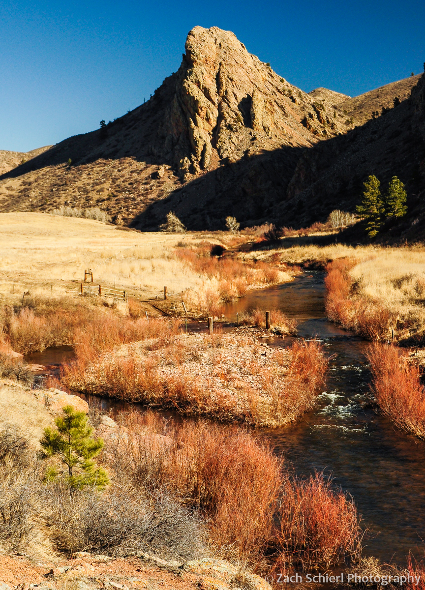
Eagles Nest Rock and the North Fork of the Cache la Poudre River

Mahoney Park, Bobcat Ridge Natural Area

Mahoney Park, Bobcat Ridge Natural Area

Top 10 from 2014

As in past years, with the coming of the New Year I decided to take a look back at all the photos I took in 2014 and select some of my favorites to share with you here on the blog. Between finishing graduate school (yippee!) and making a permanent (for now) move from the Pacific Northwest to Colorado, I had less time to devote to photography than in previous years. Nevertheless, picking out my favorite photos was difficult as usual and a good reminder that I was fortunate to have the opportunity to experience and photograph a a number of new places in the past year, from the coasts of Olympic National Park to remote alpine basins in the Rocky Mountains.

Without further ado, here are my ten favorite photos from 2014 in chronological order. Here’s wishing you all a healthy and happy new year!

1. Tulip Fields at Sunset, Skagit Valley Tulip Festival, Washington

Filed at Skagit Valley Tulip Festival

Held annually in April, the Skagit Valley Tulip Festival is a must see for any spring visitor to NW Washington, photography buff or not. On weekends, especially sunny ones, the tulip fields that spread out across the Skagit Valley about an hour north of Seattle are overrun, making photography difficult. Fortunately, I lived only about a half hour away and was able to visit on a less-busy weekday evening in order to photograph the picture-perfect bulbs in their prime and without the crowds.

2. American Bison, Yellowstone National Park

A solitary bison in Yellowstone National Park

I’m going to come clean: this is the only photo on this list taken from the confines of my car! I was departing Yellowstone at the end of an impromptu day-trip to the park while attending a geology conference in Bozeman when I spotted this solitary bison along the road. Fortunately, no vehicles were coming up behind me so I was able to grab my camera and capture the glow of the late afternoon sunlight and the diffuse reflection of the bison in a pool of late-season snow melt.

3. Milky Way, Airglow, and Light Pollution from Hurricane Ridge, Olympic National Park, Washington

Milky Way and airglow from Hurricane Ridge, Olympic National Park

Living near Seattle doesn’t exactly do wonders for one’s chances of observing rare celestial events. What’s one to do? Get above the clouds of course! I was thrilled to be visiting Olympic National Park during the peak of the Cameleopardalids meteor shower in May. In order to get an unobstructed view, we made the drive up to Hurricane Ridge just before midnight in hopes of catching some meteors. As you may recall, the meteor shower fizzled spectacularly but all was not lost: I was able to capture this panorama of the summer Milky Way emerging from the disgusting Seattle light dome (over 50 miles away as the crow flies) as it rose in the west. Despite the light pollution, I also managed to capture the ghostly green glow of an atmospheric phenomenon known as “airglow” (which I’ve written about previously) and the low lying clouds smothering the Elwah River Valley several thousand feet below.

4. Giant Green Anemone (Anthopleura xanthogrammica), Olympic National Park

Close-up of a Giant Green Anemone in Olympic National Park

I developed a slight infatuation with seeking out and photographing marine life during my two years in Western Washington. Timing trips to the coast with some of the lowest tides of the year helped me discover a wide variety of anemones, nudibranchs, sea stars, urchins, and much more. Anemones were perhaps my favorite group to photograph, their neon-colored and delicate tentacles waving back and forth in the surf.

5. Panorama from Hole-in-the-Wall, Rialto Beach, Olympic National Park

Panorama from top of Hole-in-the-Wall, Rialto Beach, Olympic National Park

Rialto Beach is one of the most popular spots in Olympic National Park…for obvious reasons. The short 2-mile hike to Hole-in-the-Wall was one of my favorite experiences this year. Once reaching the famous rock formation, we found an nearly entirely overgrown path that led us up to a viewpoint on the crest of Hole-in-the-Wall, getting us away from the surprisingly scant Memorial Day crowds and immersing us in expansive views of sea stacks, rocks, and islands along the Olympic coast.

6. Summer Wildflowers at Ice Lake, San Juan Mountains, Colorado

Wildflowers at Ice Lake

Despite my ravings about Rialto Beach in the previous photo, our trek to Ice Lake in the San Juan Mountains of Colorado was hands down my favorite hike of the year, and one of my most memorable ever. My only regret about this day was that we weren’t prepared for an overnight (or at least a hike back to the car in the dark!), which means I missed out on what was surely a epic sunset from the basin. Click the link above for more photos of this spectacular place.

7. Ice Lake Panorama, San Juan Mountains, Colorado

Panorama of Ice Lake, San Juan Mountains

Did I mention Ice Lake was spectacular? It snagged two of the coveted spots on the top 10 list. That means you have to go.

8. Circumpolar Star Trails from Escalante Canyon, Colorado

Star Trails from Escalante Canyon

Photographing star trails is a bit more complex in the digital age than it was with film. This was only my second legitimate attempt, but I was happy with how it turned out. Extremely long single exposures suffer from a variety of maladies so this photo is actually a composite of over 100 consecutive 30″ exposures (for the stars), and one 3″ exposure for the foreground juniper which I illuminated with a headlamp. In post-processing, I had the pleasure of removing more than a dozen aircraft which passed overhead during the hour or so it took to gather the series of exposures. I elected not to remove the two meteors (astronomical objects flashing through the frame are fine by me) but I’m looking forward to doing some more star trail photography from places not on major transcontinental flight paths.

9. Exclamation Point, Black Canyon of the Gunnison, Colorado

Black Canyon of the Gunnison from Excalmation Point

I love this photo because it exemplifies how the canyon got its name. Despite being taken at 10 o’clock in the morning, the narrow gorge carved into dark Precambrian metamorphic rocks remained shrouded in shadow, while its surroundings (and portions of the canyon bottom) are basking in the bright, mid-morning sunshine. This photo was taken from an overlook on the remote and seldom visited North Rim of Black Canyon, which offers the most spectacular views into the narrowest portion of this amazing gorge and is truly worth the effort to visit.

10. Waving Aspen and Grasses, Rocky Mountain National Park, Colorado

Waving aspen tree, Rocky Mountain National Park

I didn’t purchase any new camera gear this year, but was the recipient of a 9-stop neutral density filter for my birthday, a filter I’ve been wanting to experiment with for a while now. That filter allowed me to take this photo, a 30″ exposure at f/22 in broad daylight, and capture the motion of a colorful aspen and meadow grasses waving in the wind on a autumn day in Rocky Mountain National Park.


A Sheep, a Sheep! My Kingdom for a Sheep!

2 bighorn sheep ewes in BIg Thompson Canyon

Two bighorn sheep ewes in Big Thompson Canyon, Colorado.

After some memorable elk encounters this past fall, I’ve been on the lookout for more wildlife viewing opportunities over the past few months. A flock of several thousand Canadian geese passing overhead while extricating my car from a foot of snow at the Denver airport didn’t quite cut it so on a recent weekend, we headed out in search of one of Colorado’s most iconic creatures: the Rocky Mountain Bighorn Sheep.

It turns out that late November and early December is the best time of year to view Rocky Mountain Bighorn Sheep here in the foothills of the Colorado Rockies. This time period marks the annual bighorn sheep rut, or mating period. While the bighorn sheep rut attracts far less attention than the fall elk rut, at this time the sheep descend from higher elevations to avoid deep snowpack and are frequently seen along canyons such as the Big Thompson, just a short half hour drive from Fort Collins (where I now live).

If that name sounds familiar, it’s because Big Thompson Canyon is better known as the site of a number of large and particularly deadly floods in the past few decades than as prime bighorn territory. But in late autumn and early winter, this is the place to be for some serious sheep spotting and shooting (with a camera of course!). This is not to say the sheep are always easy to spot. The beige bighorns, with the exception of their white butts, blend into the brown and shrubby landscape extraordinarily well. Here’s a view of the second pack of sheep we spotted to better illustrate the challenge:

Four bighorn sheep in Big Thompson Canyon

Find the FOUR bighorns!

You can see the problem: brown vegetation + brown rocks + (mostly) brown sheep = hard to spot sheep. It’s like Where’s Waldo, only in real life and with sheep instead of fictional characters with questionable fashion sense. Anyways, when whizzing by at 50 mph (the minimum speed required to avoid being rear-ended by folks hellbent on getting to Estes Park) on a road with little to no shoulder, it helps to have at least one pair of eyes apart from the driver to scan the cliffs and ledges so loved by the sheep for movement or a flash of a white rump.

In the end we spotted two groups of bighorns in about two hours in the late morning, the first group containing one ram and three ewes, the second two rams and three ewes. The first group was bedded down right along the Big Thompson River, just a stone’s throw from the highway right at the entrance to the canyon. With a little creative parking and scrambling, I was able to get some good close-ups of the sheep (see top photo and below). The second group was larger and more active, but was in a gully across the river over a hundred yards from the road, well outside the range of my pathetic telephoto equipment.

The presence of two rams in the second group was exciting because it afforded the possibility of seeing the famous bighorn sheep head-butting combat ritual in action. Alas though, these rams seemed much more interested in quietly grazing on the scant remaining greenery than in slamming their heads together at speeds of more than 30 mph (who wouldn’t?)

Bighorn Sheep ram in Big Thompson Canyon

A good look at the large curved horns on the male bighorns, used in head-butting competitions with other males for the right to mate with prime females.

A bighorn sheep ewe in Big Thompson Canyon

The bighorn sheep will continue to be visible in the Big Thompson area throughout the winter (as they avoid the deep snowpack at higher elevations) although once the rut concludes they become much more averse to human contact and populated areas. Unlike some other notable large mammals of the Rockies, bighorn sheep tend to be most active during daytime hours, making them relatively easy to spot if you have a keen eye.