Fall Color in Southern Utah


A ridge coated in aspens near Brian Head, UT begins to turn color in the early fall. The view from the Markagunt Plateau is truly expansive; in the background are ranges and valleys in the Great Basin of western Utah, and on a clear day one can clearly see Wheeler Peak in eastern Nevada
Another autumn is upon us, and once again we find ourselves becoming familiar with the surroundings of a new home, this time in Southern Utah. Why this neck of the woods, with its famous expanses of colorful slickrock, isn’t more well known for fall color, I do not understand. Near Fish Lake is the largest single aspen colony in the world, which also happens to be the worlds heaviest known organism period.
A bit closer to home for us is the Markagunt Plateau, which reaches elevations of over 11,000 feet and contains expansive reaches of aspen that rival, and to be honest probably beat, any we experienced in Colorado. The weather has been fairly mild for the last month or so, with few storms and little wind, allowing the leaves to put on an extended show:

One of the unique features of the Markagunt Plateau are a number of expansive and recent (<10,000 years) lava flows that coat much of the landscape above 9000 feet. The stark lava flows provide a stunning backdrop for the brilliant fall colors that occupy pockets of soil within their midst.

Aspens and lava flows, Markagunt Plateau, UT

A beautiful grove of aspens on the Rattlesnake Creek Trail near Brian Head, UT. This trail has clearly been a popular route for quite some time; we found inscriptions on some of these aspens dating back to 1903! (Along with many more recent ones sadly…)
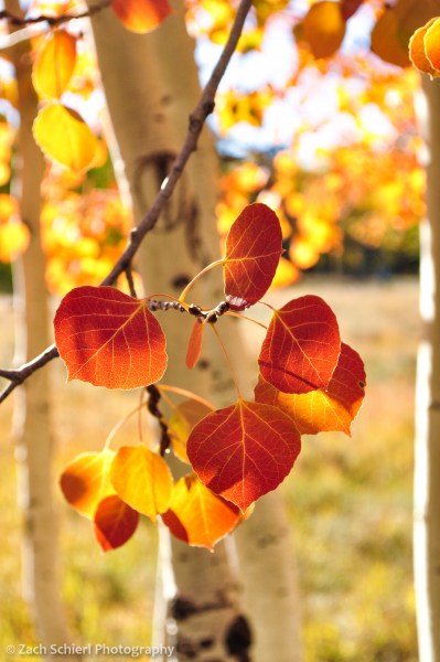
This pocket of trees near the Duck Creek Campground possessed the most vividly red leaves I’ve ever seen on aspen trees.

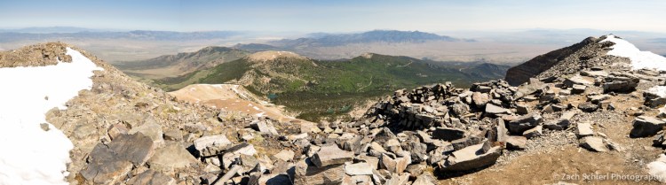
Golden aspens coat the flanks of Hancock Peak, a small cinder cone on the Markagunt Plateau. This view was obtained from the summit of Brian Head Peak, 11, 312 feet above sea level. In the distance is the western escarpment of the Paunsaugunt Plateau, home to Bryce Canyon National Park.

I pass this grove of aspens several times per week on my way to work. I had been keeping an eye on this particular tree for weeks, and on this foggy day I finally pulled the car over to snap a photo.
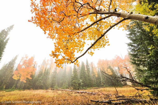
More aspens in the fog, Markagunt Plateau, Utah
Escape to the Snake Range: Great Basin National Park

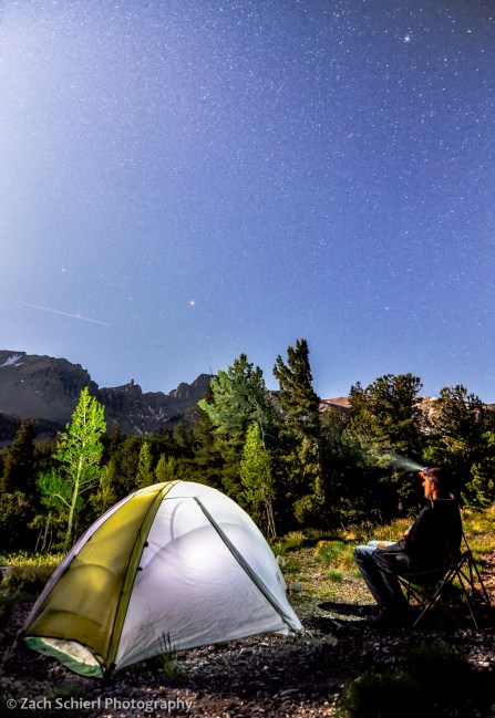
Wheeler Peak by full moonlight, Great Basin National Park, Nevada
At first glance, Nevada’s Snake Range is just one out of the hundreds of long, skinny mountain ridges that comprise the Basin and Range Province of the western United States. Clarence Dutton, a geologist associated with John Wesley Powell’s geographic and geologic surveys of the western United States in the late 1800s, once referred to the Basin & Range as “an army of caterpillars marching toward Mexico,” referring to the seemingly interminable landscape of north/south trending mountain ranges and intervening valleys that dominate Nevada, southern California, and western Utah & Arizona.
It is the presence of one of our nation’s least visited national parks, Great Basin, in the southern portion of the range that provides the first indication that the Snake Range might be somehow unique from its brethren. And indeed it is. Rising more than 7,000 feet above the surrounding terrain, the Snake Range is home to four of the five tallest peaks in the state of Nevada, culminating in 13,065′ Wheeler Peak, the second highest point in the state. The altitude and the lush spruce, fir, and aspen forests clinging to its slopes makes the area feel suspiciously like a piece of Colorado thrust up into the middle of the Nevada deserts.

Wheeler Peak just after sunset on the summer solstice
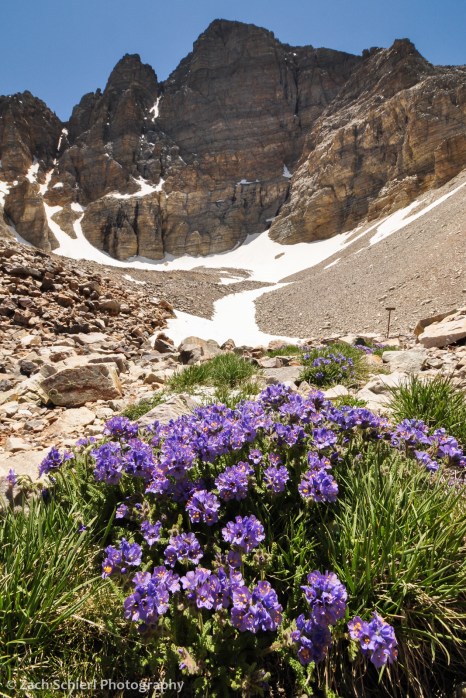
Abundant sky pilot (Polemonium viscosum) in a glacial cirque beneath Wheeler Peak, Great Basin National Park
Looking north along the Snake Range from the summit of Wheeler Peak (13,065′) on a beautiful June day
Great Basin National Park is also famous for the groves of Great Basin bristlecone pine (Pinus longaeva) found on rocky slopes near treeline. Currently believed to be the longest-living non-clonal organism on Earth, many of the bristlecones in the park exceed 3000 years in age. In an infamous 1964 incident, a Snake Range bristlecone felled by a researcher (the area had not yet been designated as a national park at the time) was posthumously determined to be nearly 5000 years old, which would have made it the oldest known tree on earth were it not for the fact that the tree was now quite dead. More recently however, a bristlecone estimated to be 5,065 years old was found in the White Mountains of eastern California, slightly surpassing the age of the doomed Great Basin tree.

A twisted and contorted Great Basin bristlecone pine (Pinus longaeva) on the slopes of Wheeler Peak, Great Basin National Park
In the final hour of my recent drive across western Utah to reach Great Basin NP, I encountered only a single other vehicle before arriving at the park entrance. The relative isolation of the park leads to perhaps its most unique attribute; Great Basin National Park is by many measures the darkest national park in the U.S., and one of the darkest locations in the country period. Sadly, my visit coincided with a full moon which, while preventing me from experiencing a light pollution-free night sky, did make for some good nightscape opportunities:

Light from the rising full moon illuminates Wheeler Peak and Stella Lake, Great Basin National Park

A Western Tiger Swallowtail (Papilio rutulus) feeds from a crimson columbine (Aquilegia formosa) along Baker Creek, Great Basin National Park
If you get sick of exploring the surface world, Great Basin also harbors a subterranean spectacle, the ornately adorned limestone cavern known as Lehman Caves. With alpine peaks, caves, ancient trees, and inky black night skies, it may seem miraculous that Great Basin remains one of the least visited national parks in the country. In 2015, Great Basin was visited by 98% fewer people than that big hole in the ground known as the Grand Canyon. Hopefully the photos on this page encourage you to stay far, far away 🙂
Rocks and (Musk)Rats of the Rockies


Textbook stream meanders along the Fall River, Rocky Mountain National Park, Colorado
A few weekends back I led my semester-ly geology field trip to Rocky Mountain National Park. Each time I end up finding new gems that I had previously overlooked, such as the spectacular stream meanders along the Fall River pictured above. One good flood and the stream will erode through the narrow strip of land separating the two meanders, leaving the bend in the middle of the photo high and dry. Places like this are a great opportunity for students to see in action a geologic process that every introductory geology instructor teaches in the classroom.
Despite many areas of the park still being covered in umpteen feet of snow, wildflowers are beginning to appear in the lower elevations around Estes Park:

Early blooming pasqueflower in Moraine Park, Rocky Mountain National Park, Colorado

Longs Peak shrouded in a late-season storm, Rocky Mountain National Park, Colorado
The biggest cause for excitement actually occurred after the field trip was over. I had intended to stick around in the park for a longer hike after setting the students free, but I quickly realized I had left my filled camelback on the kitchen counter. Lacking any sort of water carrying device, not wanting to shell out the cash to buy one, nor desiring to try to fashion one out of ungulate intestines, that plan was foiled. In lieu of a hike I headed for a short stroll around Lily Lake to try to get some pictures of the incoming storm enveloping Longs Peak.
While snapping the above photo, I was startled by what sounded like a cannonball being dropped into the lake behind behind me. My initial suspicion of hooligans launching boulders into the lake was discredited when I turned around and saw no one within half a mile. I made my way to the edge of the lake and remained motionless; after a few moments, this little guy appeared:

Beaver? Otter? Furry fish?

Lily Lake, Rocky Mountain National Park, Colorado
Noticing the presence of a nearby mass of chewed up sticks (above), I hastily assumed I was in the presence of a beaver. In short time, a second critter appeared and the pair began to tussle, albeit sadly behind a willow bush from my point of view. It soon became clear that these animals were more agile and less chunky and rotund than your typical beaver. Not being able to see them clearly with the naked eye, my next guess was river otter, which persisted until I got home and took a closer look at the pictures below. Otters would have a tough time leading their carnivorous lifestyles with only those gigantic incisors to work with. I was out of ideas (this is why I lead geology field trips, not wildlife watching trips…) , so I was forced to the internet where I learned that I had just seen my first muskrat.

Two combative muskrats in Lily Lake, Rocky Mountain National Park

Nice teeth!
Finally, on the way home, I made a quick stop at a rock shop in Estes Park that I’ve driven past dozens of times. I quickly discovered that knowledge of basic geological principles is not a prerequisite for owning a rock shop when I found a large bin of black limestone labeled:

{facepalm}
