The “Caves” of Cathedral Gorge State Park


The badlands of Cathedral Gorge State Park, Nevada
Next time you find yourself in extreme eastern Nevada with time to spare, I highly recommend checking out Cathedral Gorge State Park. This gem lies tucked away on the floor of Meadow Valley, about halfway between Las Vegas and Great Basin National Park, not far from the bustling hub of Panaca, Nevada. In other words, for a place fully accessible by paved roads, Cathedral Gorge is about as off-the-beaten path as you’re going to get.
Despite its under-the-radar status, Cathedral Gorge was established all the way back in 1935, and was one of Nevada’s four original state parks (along with the more well-known Valley of Fire north of Las Vegas). The highlight here is a shallow valley excavated out of a layer of soft lake sediments by Meadow Valley Wash and numerous small tributary streams. The sediment was originally deposited in a freshwater lake that called Meadow Valley home during wetter times in the Pliocene epoch (~2.5-5 million years ago). This area has been the epicenter for some pretty extensive volcanic activity over the past few dozen million years, so the sediment that accumulated in the lake was rich in volcanic ash.
Today, with the lake gone, the exposed sediment is so soft that it erodes extremely rapidly. Few plants can gain a foothold in earth that is crumbling so rapidly, so the water (and to a lesser extent, wind) have created a intricate landscape of badlands along the margin of the valley. The scenery is bizarre and not all that unlike what you might find in the famous badlands of South Dakota and the Great Plains. It definitely feels out of place in the sagebrush expanses of the Great Basin. While Cathedral Gorge bakes in the summertime, during our visit it was cold, windy, and virtually empty. We saw not another soul on a four mile loop hike around the perimeter of the valley.

Miller Point Overlook, Cathedral Gorge State Park, Nevada

The terminus of one of the narrow “mud slot canyons” in Cathedral Gorge State Park, Nevada
While the loop hike around the valley was enjoyable (if a bit windy), we didn’t stumble upon the highlight of our visit until we started poking around the rock formations adjacent to the trailhead parking lot. In a matter of minutes, we found ourselves exploring a landform that I still don’t have the right words to describe.
At the edge of the valley, runoff has carved a series of deep, extremely narrow, and almost perfectly vertical crevices into the soft sediments. The park calls them “caves” but the words cave, crevice, gully, crevasse, gorge, and ravine all fail to accurately capture their bizarre and truly unique nature. Perhaps the best way to describe them is as “slot canyons of mud.”
They evoke the sandstone slot canyons of Utah in the sense that they were so narrow that in many spots only a tiny sliver of blue sky could be seen overhead. Unlike most slot canyons though, whose delicate curves are clearly the result of flowing water, the walls here were angular and almost perfectly vertical. It was as if someone had carved huge blocks out of the mud with a chainsaw and then splattered the walks with mud to cover their tracks. Each little mud slot terminated abruptly in a roughly circular chamber whose walls were lined with linear grooves etched into the mud, extending all the way up to the rim. These chambers were clearly the work of waterfalls that spill into the canyons with each heavy rain.
As fragile and precarious as the mud walls looked, there were surprisingly few signs of catastrophic collapse. We explored about a half dozen of these little canyons, all of which were located right along the main road into the park. There were surely more that we missed, good enough reason to make the drive back to Meadow Valley another day.

Water flowing into the gullies erodes and redeposits mud, creating intricate shapes and patterns that line the walls.

Light streaming into a deep “mud slot canyon” in Cathedral Gorge State Park, Nevada
Escape to the Snake Range: Great Basin National Park

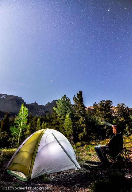
Wheeler Peak by full moonlight, Great Basin National Park, Nevada
At first glance, Nevada’s Snake Range is just one out of the hundreds of long, skinny mountain ridges that comprise the Basin and Range Province of the western United States. Clarence Dutton, a geologist associated with John Wesley Powell’s geographic and geologic surveys of the western United States in the late 1800s, once referred to the Basin & Range as “an army of caterpillars marching toward Mexico,” referring to the seemingly interminable landscape of north/south trending mountain ranges and intervening valleys that dominate Nevada, southern California, and western Utah & Arizona.
It is the presence of one of our nation’s least visited national parks, Great Basin, in the southern portion of the range that provides the first indication that the Snake Range might be somehow unique from its brethren. And indeed it is. Rising more than 7,000 feet above the surrounding terrain, the Snake Range is home to four of the five tallest peaks in the state of Nevada, culminating in 13,065′ Wheeler Peak, the second highest point in the state. The altitude and the lush spruce, fir, and aspen forests clinging to its slopes makes the area feel suspiciously like a piece of Colorado thrust up into the middle of the Nevada deserts.

Wheeler Peak just after sunset on the summer solstice
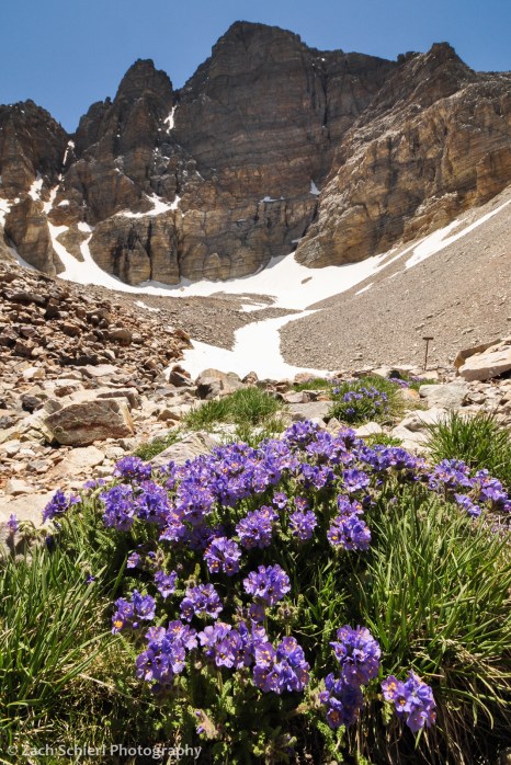
Abundant sky pilot (Polemonium viscosum) in a glacial cirque beneath Wheeler Peak, Great Basin National Park
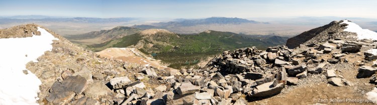
Looking north along the Snake Range from the summit of Wheeler Peak (13,065′) on a beautiful June day
Great Basin National Park is also famous for the groves of Great Basin bristlecone pine (Pinus longaeva) found on rocky slopes near treeline. Currently believed to be the longest-living non-clonal organism on Earth, many of the bristlecones in the park exceed 3000 years in age. In an infamous 1964 incident, a Snake Range bristlecone felled by a researcher (the area had not yet been designated as a national park at the time) was posthumously determined to be nearly 5000 years old, which would have made it the oldest known tree on earth were it not for the fact that the tree was now quite dead. More recently however, a bristlecone estimated to be 5,065 years old was found in the White Mountains of eastern California, slightly surpassing the age of the doomed Great Basin tree.

A twisted and contorted Great Basin bristlecone pine (Pinus longaeva) on the slopes of Wheeler Peak, Great Basin National Park
In the final hour of my recent drive across western Utah to reach Great Basin NP, I encountered only a single other vehicle before arriving at the park entrance. The relative isolation of the park leads to perhaps its most unique attribute; Great Basin National Park is by many measures the darkest national park in the U.S., and one of the darkest locations in the country period. Sadly, my visit coincided with a full moon which, while preventing me from experiencing a light pollution-free night sky, did make for some good nightscape opportunities:

Light from the rising full moon illuminates Wheeler Peak and Stella Lake, Great Basin National Park

A Western Tiger Swallowtail (Papilio rutulus) feeds from a crimson columbine (Aquilegia formosa) along Baker Creek, Great Basin National Park
If you get sick of exploring the surface world, Great Basin also harbors a subterranean spectacle, the ornately adorned limestone cavern known as Lehman Caves. With alpine peaks, caves, ancient trees, and inky black night skies, it may seem miraculous that Great Basin remains one of the least visited national parks in the country. In 2015, Great Basin was visited by 98% fewer people than that big hole in the ground known as the Grand Canyon. Hopefully the photos on this page encourage you to stay far, far away 🙂
Great Basin Thunderstorm

Thunderstorm in the Great Basin, Spring Valley, NV
