Exploring the Mt. Adams Wilderness


Mt. Adams is the largest (by volume) and second highest volcano in the Cascade Range of Washington. Often overshadowed by its neighbors, Mt. Rainier, Mt. St. Helens, and Mt. Hood, we’ve taken a liking to Adams in part because its trails tend to be relatively deserted and in part because we have a fantastic view of the mountain’s east face from our neighborhood in the Yakima Valley. Recently we had the chance to complete a short backpacking trip on the north flank of the mountain which allowed us vantage points that far surpass anything we’ve seen on previous day hikes.
Our hike began and ended at a trailhead (Killen Creek) that is, as the crow flies, just 57 miles from our front door, but takes more than three hours to reach by car, giving some sense as to the relative remoteness of this area. Most of our ~20 mile loop was within the Mt. Adams Wilderness, a 48,000 acre wilderness area designated in 1964 with the original passage of the Wilderness Act.

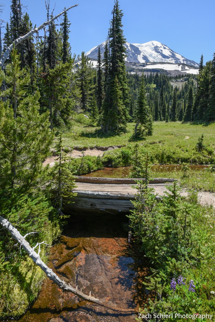
On our first night, we camped at just under 7,000 feet on the north flank of the mountain in one of the most spectacular alpine meadows I’ve seen. No matter which way I turned, the views were extraordinary. To our south, the crumbling volcanic edifice of Mt. Adams loomed large, with the Adams Glacier descending in a stunning icefall from the summit plateau. To the north, broad expanses of dense evergreen forest stretched off into the distance, leading the eye to the massive Mt. Rainier and the rugged skyline of the Goat Rocks on the horizon. To the west, the truncated cone of Mt. St. Helens was backlit by the setting sun. Several lingering snowfields surrounded our campsite, providing a nice source of clear, cold water. A variety of diminutive alpine wildflowers were in full bloom, and the low rumble of rock and ice fall high on the mountain occasionally punctuated the silence, with clouds of dust the only clue as to their location. While this location is reachable by a long day hike, spending the night and being able to explore and photograph in the late afternoon and evening light is one of my favorite things about backpacking!


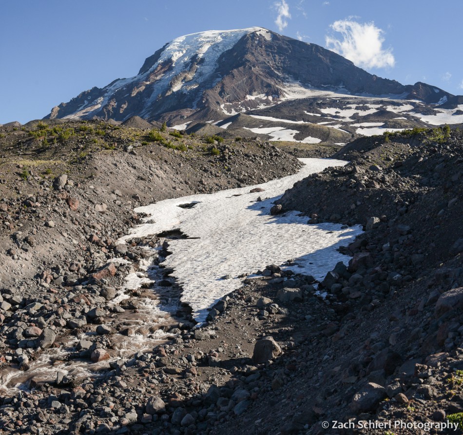
On Day 2, we descended to the Pacific Crest Trail before working our way around to the northeast side of Mt. Adams, passing through a series of wildflower-filled meadows and crossing several inviting streams cascading down from melting snowfields and glaciers higher on the mountain. These meadows also hosted a robust population of mosquitos and other biting insects….not unexpected for the Cascades in July, but an annoyance nonetheless, especially for an Arizona-born desert rat like me!

We had shared the trail with quite a few other hikers and backpackers on Day 1, but saw only a few other people from this point forward. Camp on night two was in a small clump of trees on the edge of a relatively recent lava flow. In contrast to the verdant alpine meadows of night one, this landscape was much more rugged, barren, and stark. After setting up our tent, we proceeded up the trail (with much lighter packs!) to find a spot for dinner. We quickly arrived at a stream crossing that we didn’t feel comfortable fording, so we left the trail behind and proceeded to pick our way up the rubbly bank until we arrived at a small knob with a spectacular view of the glaciers on Mt. Adams’ northeast face (Lava, Lyman, and Wilson). Here we enjoyed a delicious meal of instant mashed potatoes mixed with green chiles and an entire bag of bacon bits while listening to the roar of the creek.
Our best wildlife sighting of the trip actually occurred on the drive to the trailhead, when we happened upon a young barred owl sitting in the road. As we approached it flew into a nearby tree where it watched us warily for a few minutes before fleeing deeper into the forest:

Aside from this, we saw surprisingly little wildlife on this trip (unless you count mosquitos): only a few birds, chipmunks, squirrels, and a single marmot and mountain goat in the far distance from our first camp.
From our second camp, we were in a great position to catch sunrise on the final morning of our trip. There aren’t many things I’ll get up at 5:15 am for, but a Mt. Adams sunrise is definitely one of them!

After packing up, we hiked the eight downhill miles back to our car and drove back into the 100 degree blast furnace that is the Yakima Valley in late-July. We are thankful to have beautiful places like Mt. Adams so close to escape the heat this time of year!
Summiting Mt. St. Helens


Looking east along the crater rim of Mt. St. Helens to Mt. Adams in the distance.
Of all the volcanoes in the northern Cascades, Mt. St. Helens is by far the easiest to climb. For starters, the most common route, Monitor Ridge on the south flank, is non-technical, eliminating the need for specialized gear or advanced mountaineering skills. At just 8,366 feet, its summit elevation post-1980 eruption places it several thousand feet lower than neighbors such as Mt. Adams, Mt. Baker, and Mt. Rainier, essentially taking the ill effects of altitude out of the equation. However, at 10 miles round trip and with about 5,000 feet of elevation gain, it’s still a robust day hike.
After numerous trips to the base of Mt. St. Helens over the years, reaching the summit of this active volcano has long been on my to-do list. When we moved back to Washington last summer, I knew I might finally get my chance. The Gifford Pinchot National Forest limits the number of climbers to 100 per day in the summer months, and the permits sell out quickly when they go on sale in March. Sadly, I missed the initial sale this year, leaving me to obsessively check every few days for cancellations. Eventually I got lucky and spotted two permits up for grabs in late-July. A few minutes later, they were mine.
From a distance and elevation gain standpoint, the hike up Monitor Ridge is comparable to many of Colorado’s famous “Fourteeners”. One major difference: on Mt. St. Helens we would be topping out at a lower elevation than one starts most Fourteener climbs at. The other big difference would be the terrain. Most Fourteeners have a fairly distinct path a good way up the mountain and are on reasonably solid rock (my dislike of exposure and falling means I haven’t done any of the ones on rotten rock). On Mt. St. Helens, after a brief foray through the forest, the climb traverses a mixture of large lava boulders and a loose scree consisting of pumice and volcanic ash. This is a hike where a mask was on the suggested gear list before they were cool!
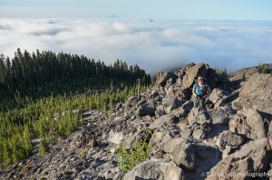
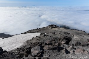
To the hike! As the National Weather Service had accurately predicted several days in advance, the morning of our climb dawned with some fairly dense fog at the Climbers Bivouac trailhead where we had camped the previous night. We hit the trail at 6:00 am, anticipating that it would take us 4-5 hours to reach the summit. The first two miles of trail climbs gently through a moist and somewhat unremarkable second growth forest. At timberline is where the route changes from a well-maintained trail to the aforementioned scree and boulder scramble. Wooden posts serve as guides for the remainder of the climb, but following them too closely didn’t always make for the most sensible route. In places there is a fairly obvious path, while in others (particularly in the boulder fields), you just sort of have to find what works best. Just before arriving at timberline, we began to emerge from the clouds, revealing views of Mt. Adams to the east and the extremely conical Mt. Hood to the south that we enjoyed the rest of the day. Once above the trees, our pace slowed significantly, but before too long we were several hundred feet above the cloud deck we had been immersed in a short time earlier:
Breaking out of the trees on the Monitor Ridge route.

Heading up Mt. St. Helens with the clouds below us and Mt. Hood in the background.
Nearing the top of the boulder field on the Monitor Ridge route. Only a mile to go!
We made fairly good time through the ~2 miles of boulder fields. The final mile through a deep and loose mixture of volcanic ash and pumice was definitely the most challenging part of the hike. With masks on to prevent inhaling clouds of ash kicked up by our feet (and the wind), it was somewhat analogous to hiking up a sand dune: two steps forward, one step back, repeat. After about four hours, we were standing on the crater rim.
The first view northward into the bowels of Mt. St. Helens was stunning, and definitely one of the most dramatic viewpoints I can recall. Unlike many lesser peaks in the Cascades, or most peaks in the Rockies, where you are often surrounded by other peaks of comparable elevation, Mt. St. Helens stands alone. On this volcano, you are standing on what is, by far, the highest point for dozens of miles in any direction, with only the other volcanoes exceeding you in height. Looking down onto the crater formed by the 1980 eruption, the lava domes that are slowly rebuilding the summit, and the Crater Glacier (one of the few alpine glaciers in the world that is actually advancing) was spectacular. Cornices of hard-packed, dirty snow clung to the nearly vertical slopes of the crater walls just beneath our feet, necessitating caution as we moved our way along the rim. Gentle puffs of steam were visible on portions of the lava dome, a gentle reminder that we were standing at the summit of one of the most active volcanoes in the world. The dull roar of rock and ice fall from the crater walls was nearly constant for the hour we spent taking in the view from the summit.

Panorama from the Mt. St. Helens crater rim, looking north across the lava dome and Crater Glacier to Spirit Lake and Mt. Rainier. (Click image to enlarge)

Panorama looking south from the crater rim. Mt. Adams at left, Mt. Hood just left of center. (Click image to enlarge)
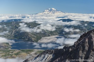
Clouds part to reveal Spirit Lake and the distant cone of Mt. Rainier, more than 4,000 feet higher that Mt. St. Helens.
While the hike up had been relatively uneventful, the journey down was definitely less pleasant. Hiking poles are a must for the descent due to the steep, loose, and rocky terrain. This is definitely one of those hikes where coming down is exponentially more difficult than going up!
Compared to our experience hiking Fourteeners in Colorado, the significantly lower elevation of this hike makes a huge difference and in my opinion dramatically lowers the overall difficultly of this route. There is a big difference between inching your way up a scree slope at 13,000′ and having to stop every few steps to take in oxygen, and doing the same at 8,000′ where breathing isn’t as much of an issue. While the terrain was definitely more difficult than your average hike with similar specs, in the end we felt like the difficulty of the Monitor Ridge route was somewhat over-hyped based on some of the accounts we read in advance. We wouldn’t hesitate to do it again. As far as special gear, a mask was definitely helpful for both COVID and volcanic ash purposes. Hiking poles were more or less useless on the way up, as the boulder fields often required the use of hands to navigate, but essential on the way down. Other sources recommended bringing garden gloves to protect against cuts on the sharp volcanic rocks. We bought some cheap ones and definitely found them useful. I never actually put mine on during the ascent, and made it to the summit with only one small abrasion on the back of my hand. Long pants are also a must if you don’t want your lower legs ripped to shreds by the rocks.
With Mt. St. Helens checked off, next up on the to-do list is Mt. Adams, which is also a non-technical climb at the right time of year, albeit longer. We may not get to that one this summer…perhaps our goal will be to climb one Cascade volcano per year!
Mt. St. Helens: 40 Years Later


The volcanic cone of Mt. St. Helens rises above grassy slopes covered with scarlet paintbrush (Castilleja miniata).
This past May marked the 40th anniversary of one of the most significant natural disasters in U.S. history: the 1980 eruption of Mt. St. Helens. 2004 to 2008 brought another series of eruptions, but today Mt. St. Helens is quiet. Stratovolcanoes such as Mt. St. Helens generally provide some degree of warning (often in the form of earthquakes or surface deformation) before erupting. Given that Mt. St. Helens is one of the most closely monitored volcanoes in the U.S. (if not the world), the lack of activity in recent years has once again made the surrounding landscape a recreational destination.
The northeast side of Mt. St. Helens is just a few hours from our front door, accessed via a series of forest service roads that, while technically paved, are in such poor condition that one pines for the sweet rhythm of dirt washboards. Much of the land most directly affected by the 1980 eruption is protected as the Mt. St. Helens National Volcanic Monument, established two years after the eruption. Camping and off-trail travel is restricted across a large swath of the monument to allow scientific study of how the landscape evolves post-eruption, with minimal human disturbance. Recently, we took a short backpacking trip to the northeast flank of the mountain, where camping is allowed, but where recurring volcanic activity has still left the landscape relatively devoid of tall vegetation. The result is spectacular views of Mt. St. Helens itself and the surrounding terrain (and, it turns out, any bright comets that happen to be gracing the skies.)
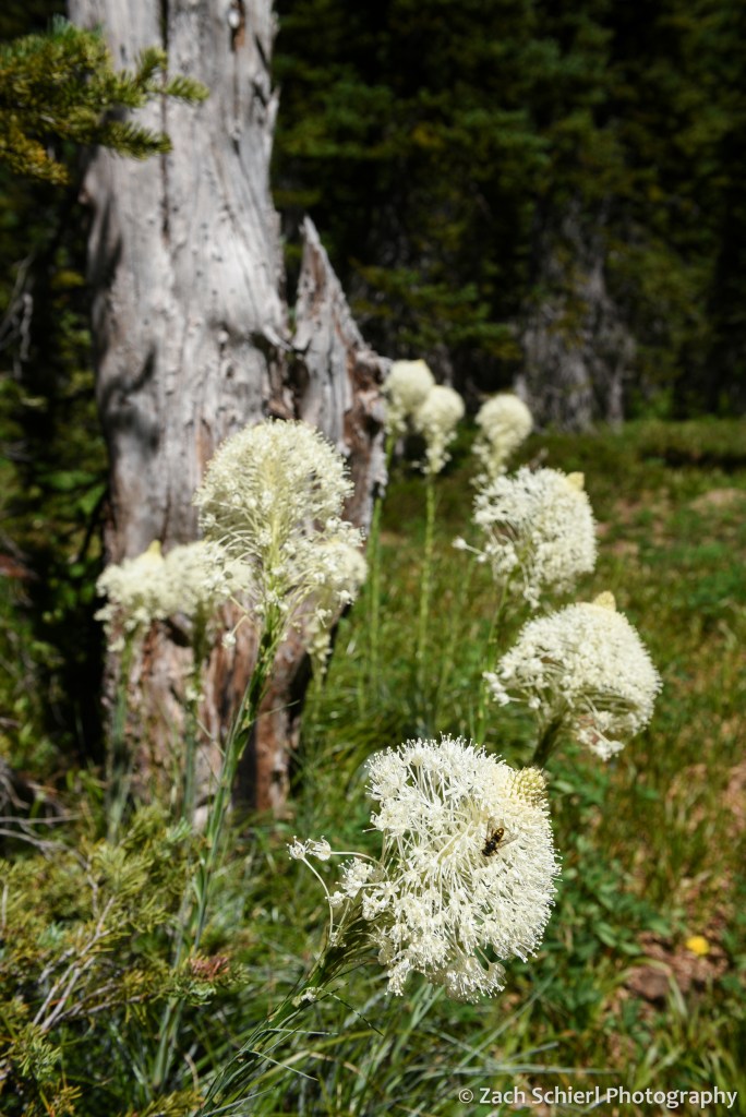
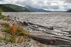
This was my third visit to the area but first in about 10 years. My previous visits had been in late summer and early fall, when the only wildflowers to speak of were some hardy stalks of late-blooming fireweed. On this visit, in early July, the grassy slopes of the lower mountain were awash in what can only be described as a riot of wildflowers. Paintbrush and penstemon dominated the scene, resulting in slopes that glowed red and purple from miles away and absolutely lit up at sunset and sunrise. It was truly one of the most spectacular wildflower displays I have ever seen!

Scarlet paintbrush (Castilleja miniata) and Cardwell’s penstemon (Penstemon cardwellii) frame our campsite on a barren pumice slope on the northeast flank of Mt. St. Helens.
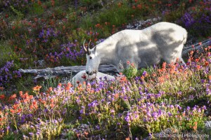
We settled on a campsite located on a small, barren ridge of pumice and ash where we could set up for the evening without impacting the gorgeous display all around us. Shortly thereafter, a handful of mountain goats came wandering through…with a good deal less regard for the wildflowers. While this was slightly concerning at first, as mountain goats can be aggressive, they seemed to be enjoying the buffet too much to notice our presence. We watched them slowly eat their way up-slope behind our campsite for well over an hour (as we somewhat nervously heated up our cans of soup and baked beans, while hoping that they continued to find the scent of the penstemon more attractive) before they finally bedded down on a distant ridge for the evening.
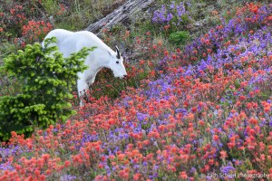
A mountain goat (Oreamnos americanus) is paralyzed by indecision while looking at the wide array of tasty offerings, Mt. St. Helens National Volcanic Monument, Washington.
“The paintbrush looks tasty!”
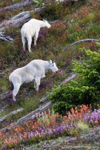
Mountain goats, Mt. St. Helens National Volcanic Monument, Washington

A mountain goat surveys the lower, barren slopes of Mt. St. Helens.
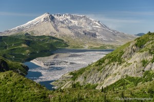
On just a few hours of sleep, we hiked back out to our car the next morning and enjoyed some day hikes to the north of Mt. St. Helens over the next two days. This area provides the best vantage point for viewing the effects of the 1980 eruption. The blast reduced the elevation of Mt. St. Helens by over 1,000 feet, replacing the formerly sharp summit with a massive crater. Part of the crater has since been filled in by a lava dome extruded in the months following the eruption, and again during the eruptive sequence of 2004-2008. Another dramatic feature of the landscape is Spirit Lake. This once idyllic destination was directly in the path of the eruption on May 18, 1980. The massive landslide associated with the eruption filled in a large portion of the lake with debris, pushing the entire lake northward and raising the water level by about 200 feet, burying numerous buildings, camps, and, unfortunately, Mt. St. Helens Lodge owner Harry Truman, who had steadfastly ignored evacuation orders in the weeks leading up to the eruption. To this day, a massive raft of logs floats on the lake surface, the remains of trees uprooted in the 1980 eruption.
Mt. St. Helens from Bear Pass. In the foreground is Spirit Lake, covered with floating logs: the remains of trees uprooted by the 1980 eruption of Mt. St. Helens and washed into the lake.
The log raft as seen from lake level at the end of the Harmony Trail, the only legal access to the shore of Spirit Lake.
As a geologist, I find the landscape around Mt. St. Helens endlessly fascinating. Changes since my last visit 10 years ago were clearly visible in many places. Mt. St. Helens is the most active of the Cascade volcanoes and will certainly erupt again. Perhaps nowhere is it more clear that the current configuration of the Earth’s surface is ultimately temporary.
