Into the Valley of Death (Part 3): Canyon Combing


“Canyon of Color”: A walk through lower Gower Gulch reveals rocks in nearly every color of the spectrum
No tour of Death Valley would be complete without a peek into the myriad of mysterious canyons that slice abruptly into the mountain ranges surrounding the valley. When rain does bless Death Valley, it often arrives quickly and in large quantities, which can quickly turn a storm from a blessing into a nightmare. With little soil and few plants to soak up the water, most precipitation ends up rapidly draining into creeks and streams. Canyons that are bone dry 99% of the year can almost instantaneously find themselves channeling deadly flash floods, mudflows, and debris flows. Each time this happens, the canyons get slightly deeper (and the mountains slightly smaller) as the water picks up and transports bits of rock down to the valley floor where it dumps them in large piles known as alluvial fans. If the mountains weren’t continually being uplifted by tectonic forces (which most of the ranges in Death Valley are), this process would quickly erase the mountains from the landscape.
In October 2015 (just a few months before our visit), portions of Death Valley received several inches of rain in just a few hours, a nearly unprecedented storm for such a dry environment. Many roads were damaged or wiped out completely by floods and debris flows and portions of the park remained closed even several months later.
One of the most interesting canyons in Death Valley is Gower Gulch, located just south of Furnace Creek. Until recently, Gower Gulch was a small, run-of-the-mill canyon carved into the soft, buff-colored badlands of the Furnace Creek Formation. Things took a dramatic turn in the 1940s when the waters of the nearby (and much larger) Furnace Creek Wash were deliberately diverted into Gower Gulch in an attempt to prevent them from flooding populated areas downstream. With the drainage area of Gower Gulch enlarged by over 16,000%, periodic floods began to incise Gower Gulch at an alarming rate. The Gulch has deepened by more than 20 feet in just the last several decades, an erosion rate nearly unheard of in the geological world. The rapid erosion rate has caused some unintended consequences to overlooks, roads, and other park infrastructure but has simultaneously provided geologists with a fascinating window into what happens when you make a stream too big for its own britches.

Late afternoon sunlight bathes the cliffs above Gower Gulch in golds, pinks, and oranges. Note the mud line on canyon wall.
Gower Gulch had experience once of these erosive floods just a few months prior to our visit. The lower walls of the canyon were still coated in a thin layer of tan mud left behind by the October 2015 floods. In many cases, the mud line was 10-15 feet high. Little imagination was needed to realize that Gower Gulch would be a terrifying place to be during such an event!

Two different types of flood deposits in Gower Gulch; multicolored gravel originating from Furnace Creek Wash, and buff-colored mud from the badlands surrounding the gulch.
An hour north of Gower Gulch is Mosaic Canyon. Cut into the Panamint Mountains the rise to the west of Death Valley, Mosaic Canyon also experiences mudflows and debris flows during intense rains. The bedrock of the canyon is ancient dolomites, limestones, and marbles; in many places, these rocks have been polished to a shine by floodwaters roaring through the canyon.
The highlight and namesake of the canyon though are the spectacular deposits of breccia (a sedimentary rock made of coarse-grained, angular rock chunks cemented together by a finer-grained matrix) that have been pasted onto the canyon walls by repeated debris flows. The high carbonate content of the rocks allows percolating water to quickly cement the debris flow deposits together into a solid layer that can adhere to the canyon walls. The fragments of rock within the breccia are a representative sample of those that comprise the Panamint Mountains, and thus vary widely in color making the breccia appear like a complex fresco created by a powerful force of nature.

Mosaic Canyon gets its name from the colorful breccias that coat much of the canyon wall.

More breccia in Mosaic Canyon, Death Valley National Park

Colorful breccia fills a depression carved into the polished marble walls of lower Mosaic Canyon, Death Valley National Park
One can hike up Mosaic Canyon (some moderate scrambling required) for about a mile and a half, admiring the rock formations, before coming to a ~50 high cliff (a waterfall during wet periods) that inhibits further upstream travel. Hiking up Mosaic Canyon is truly spectacular, each bend reveals a new assortment of geological treasures, only some of which are pictured here.

A hike up Mosaic Canyon ends here unless you have a rope; behind me is a 50′ dry waterfall

The character of Mosaic Canyon change with every bend!
Into the Valley of Death (Part 2): Ventifacts and Dunes

Wind gets far more credit for shaping the surface of the Earth than it should. Contrary to popular belief, wind is a relatively poor sculptor of landscapes, especially when compared to water in its many forms.
Remove water from the equation though, and the influence of wind becomes magnified. The planet Mars is a great example. Dry for billions of years, with no streams or ocean waves to shape its landscape, Mars has become a barren land of sand dunes and sandblasted rocks.
If you want to experience a Mars-like landscape without the inconvenience of a long flight, Death Valley just might be your best bet. Here, water is so sparse that the effects of wind are more prominent and striking than anywhere I’ve ever visited.

Martian-like landscape on Ventifact Ridge, Death Valley National Park. A snow-dusted Telescope Peak (11,043′) is visible in the background.

Looking east along Ventifact Ridge toward the Black Mountains
My personal favorite wind-driven geologic phenomenon are what are geologists call “ventifacts.” Ventifacts are rocks (usually boulder-sized) that have essentially been sandblasted by wind-blown sand particles for extended periods of time. Ventifacts are consequently pockmarked with an array of pits, grooves, gouges, striations, and etchings that betray their uncomfortable past. Near Badwater in southern Death Valley, a low, linear ridge covered in boulders of dark black volcanic rock juts out into the valley, intercepting the strong winds that often blow along the valley’s length. Nearly every rock on this ridge shows these telltale signs of sandblasting. Combined with the lack of vegetation, photos from here resemble many of those taken by the Mars rovers more than just about anywhere else on Earth.

Ventifact and sand ripples, Death Valley National Park

A pair of excessively pockmarked ventifacts. Note that the top portion of the foreground ventifact has been completely eaten away near the top.
Larger ventifacts like the one below often take on an exceptionally strange shape. This is because wind (even very strong wind) is incapable of picking up anything bigger than a large grain of sand, and even then it can’t lift it more than a few feet off the ground. The result is that the bottom two or three feet of the bounder gets abraded away, while the top remains relatively intact, leading to the classic “hourglass” shape of large ventifacts.

Yours truly atop a large roadside ventifact in Death Valley
All of the sand blown along the valley has to go somewhere. In several locations around Death Valley National Park, mountain ranges act as obstacles to wind, and where the wind stops or slows, the sand is deposited in large dune fields.
Death Valley has not shortage of dunes but the most accessible are the Mesquite Flat Dunes near Stovepipe Wells. Unfortunately, the proximity of these dunes to paved highways means that they are also one of the most visited locations in the park. Upon arrival at the dunes a bit before sunset, we were immediately greeted by the high-pitched insectile buzz of an amateur drone (currently prohibited in national parks) hovering overhead. Fortunately, such devices have a limited range and we were soon free of the annoyance. Even though the Sun was getting low, our plan was to stay awhile. Before long, the Sun set, the stars came out and we had the dunes almost entirely to ourselves as the nearly full Moon illuminated our path:

A clear winter night in the Mesquite Flat Sand Dunes, Death Valley National Park. The yellowish glow on the horizon at right is light pollution from Las Vegas, nearly three hours away.

Ripples in the sand, Mesquite Flat Sand Dunes, Death Valley
One unique feature of the these dunes is the presence of large patches of dried & cracked mud between the dune crests. Having been to dozens of different sand dunes, seeing anything other than sand (and the occasional hardy bush) in a field of sand dunes in a strange sight. The origin of the mud is connected to the fact that the dunes lie nestled against the base of the Panamint Mountains. Periodically, mudflows and debris flows burst forth from the canyons at the foot of these mountains, migrating their way into the low spots between the dunes. The mud dries quickly in the arid climate, forming the large mudcracks. The sand dunes, constantly in a state of motion, eventually bury most of the mudflow deposits, leaving only portions peeking through.

Mudcracks in the Mesquite Flat Sand Dunes, the dried remains of mudflows from the Panamint Mountains that occasionally penetrate the dunes. The Pleaides star cluster is visible near the top of the photo.
Coming up in part three, we leave the valley behind and explore the myriad of canyons cut into the mountains ringing Death Valley. Then it’s on to Joshua Tree!
Fun in the Fort Collins Foothills

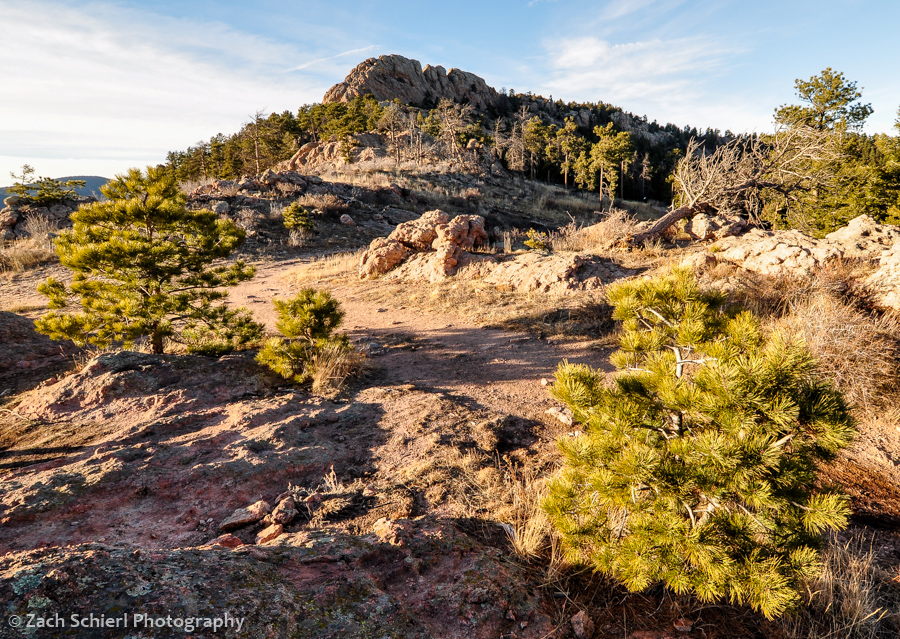
Horsetooth Rock, a famous Fort Collins landmark, is composed of hard Precambrian pegmatite.
It is currently snowing so hard I can barely see across the street. Fortunately, I haven’t been able to say this very often this winter, and I strongly suspect it won’t even be true 10 minutes from now. After six winters in the Pacific Northwest, once again residing somewhere where “warm” and “dry” are not mutually exclusive weather conditions has been quite refreshing. The mild weather has made hiking and all the other outdoorsy things that are practically a prerequisite for obtaining a Colorado driver’s license quite enjoyable. I’ve written about some of my adventures up to Rocky Mountain National Park but have yet to share any photos of our more immediate surroundings here in Fort Collins.
Fort Collins itself, lying at the extreme western edge of the Great Plains, is…well…flat. The only sledding hill I’ve yet seen here is a pathetic 20 foot run down the side of a large pile of gravel in the corner of the college football stadium parking lot. (As you’ll notice though, there is very little snow in any of these photos, so this is sort of a moot point.) Immediately west of town though lie the foothills of the Rocky Mountains, a beautiful landscape of ridges and valleys that mark the boundary between the plains and the Rockies.
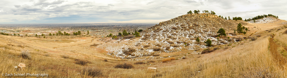
Overlooking Fort Collins just before sunset from cuestas (ridges) between town and Horsetooth Reservoir.

Colorful lichens coating sandstone ledges of the Cretaceous-age Lytle Formation, Coyote Ridge Natural Area.
Geologically speaking, the foothills are fascinating (though geologists find just about any landscape fascinating…heck even Iowa has one of the largest asteroid impact craters on Earth lurking just beneath its surface) because they represent where the Rocky Mountains pushed their way up through the crust. Prior to the uplift of the Rockies, this portion of Colorado was covered in a thick, continuous stack of colorful but more or less flat-lying sedimentary rock layers, much like one sees at the Grand Canyon today. Eventually, the Rockies thrust their way upward through the sedimentary rock, forcing the formerly flat layers to tilt toward the east. Over time, the softer sedimentary layers were (relatively) easily eroded away, forming long north/south trending valleys. Other layers were harder and resistant to erosion, forming dramatic sloping ridges known as cuestas and hogbacks that parallel the valleys.
The resulting pattern of alternating ridges and valleys is striking and has practical uses as well. In many places, streams flowing out of the mountains have been dammed at the point where they slice through the ridges, forming long, slender reservoirs that flood the valley bottoms. Horsetooth Reservoir, which provides some drinking water for Ft. Collins and irrigation water for the plains, is perhaps the best example.

Devils Backbone, a nearly vertical hogback of Dakota Sandstone south of Fort Collins.
Slightly further west, the landscape changes as the sedimentary layers give way to the igneous and metamorphic rocks that compose the bulk of the Rockies, forming famous local landmarks such as Horsetooth Rock (above) and Arthur’s Rock.
The plethora of city, state, and county parks that protect large swaths of the foothills are increasingly important as the cities below the foothills encroach on wildlife habitat. Mammals like deer, elk, bobcat, and bear are abundant in the foothills. As the cities below continue to push up against, and even into, the foothills, it’s not uncommon to read stories in the local newspaper about a moose, bear, or mountain lion wandering into town.

Mule Deer, Maxwell Natural Area

Black-tailed prairie dog, Coyote Ridge Natural Area

Cottontail rabbit, Coyote Ridge Natural Area
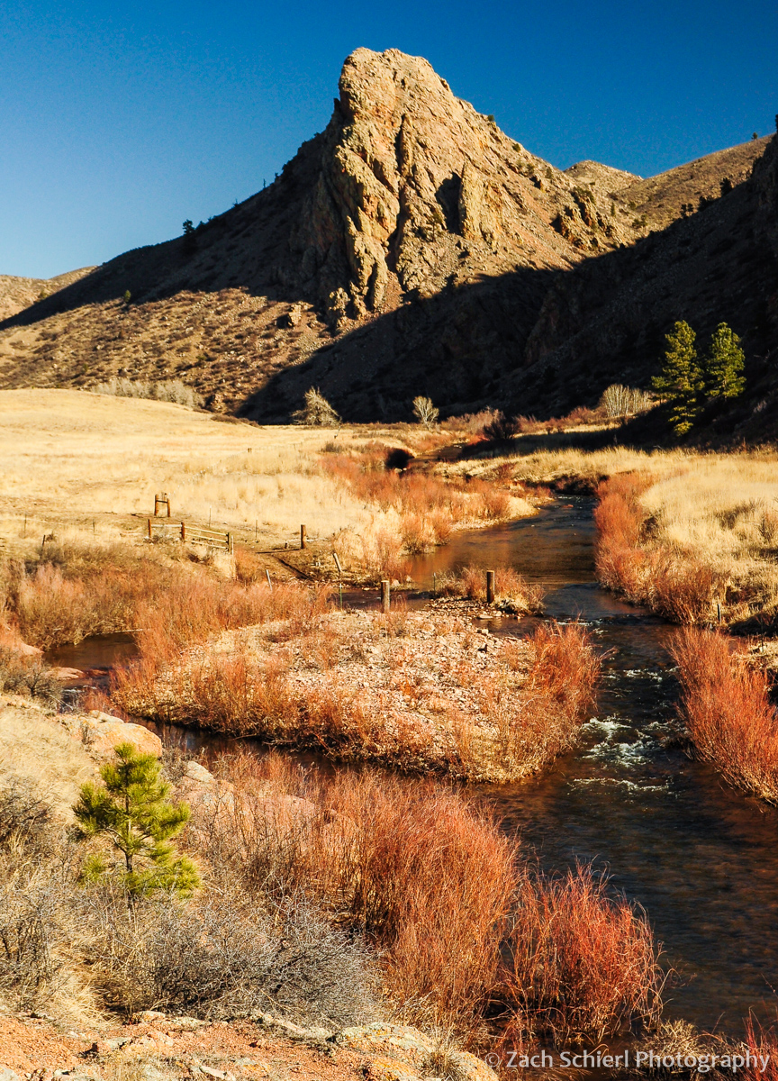
Eagles Nest Rock and the North Fork of the Cache la Poudre River

Mahoney Park, Bobcat Ridge Natural Area
