Mt. St. Helens: 40 Years Later


The volcanic cone of Mt. St. Helens rises above grassy slopes covered with scarlet paintbrush (Castilleja miniata).
This past May marked the 40th anniversary of one of the most significant natural disasters in U.S. history: the 1980 eruption of Mt. St. Helens. 2004 to 2008 brought another series of eruptions, but today Mt. St. Helens is quiet. Stratovolcanoes such as Mt. St. Helens generally provide some degree of warning (often in the form of earthquakes or surface deformation) before erupting. Given that Mt. St. Helens is one of the most closely monitored volcanoes in the U.S. (if not the world), the lack of activity in recent years has once again made the surrounding landscape a recreational destination.
The northeast side of Mt. St. Helens is just a few hours from our front door, accessed via a series of forest service roads that, while technically paved, are in such poor condition that one pines for the sweet rhythm of dirt washboards. Much of the land most directly affected by the 1980 eruption is protected as the Mt. St. Helens National Volcanic Monument, established two years after the eruption. Camping and off-trail travel is restricted across a large swath of the monument to allow scientific study of how the landscape evolves post-eruption, with minimal human disturbance. Recently, we took a short backpacking trip to the northeast flank of the mountain, where camping is allowed, but where recurring volcanic activity has still left the landscape relatively devoid of tall vegetation. The result is spectacular views of Mt. St. Helens itself and the surrounding terrain (and, it turns out, any bright comets that happen to be gracing the skies.)
This was my third visit to the area but first in about 10 years. My previous visits had been in late summer and early fall, when the only wildflowers to speak of were some hardy stalks of late-blooming fireweed. On this visit, in early July, the grassy slopes of the lower mountain were awash in what can only be described as a riot of wildflowers. Paintbrush and penstemon dominated the scene, resulting in slopes that glowed red and purple from miles away and absolutely lit up at sunset and sunrise. It was truly one of the most spectacular wildflower displays I have ever seen!

Scarlet paintbrush (Castilleja miniata) and Cardwell’s penstemon (Penstemon cardwellii) frame our campsite on a barren pumice slope on the northeast flank of Mt. St. Helens.
We settled on a campsite located on a small, barren ridge of pumice and ash where we could set up for the evening without impacting the gorgeous display all around us. Shortly thereafter, a handful of mountain goats came wandering through…with a good deal less regard for the wildflowers. While this was slightly concerning at first, as mountain goats can be aggressive, they seemed to be enjoying the buffet too much to notice our presence. We watched them slowly eat their way up-slope behind our campsite for well over an hour (as we somewhat nervously heated up our cans of soup and baked beans, while hoping that they continued to find the scent of the penstemon more attractive) before they finally bedded down on a distant ridge for the evening.

A mountain goat (Oreamnos americanus) is paralyzed by indecision while looking at the wide array of tasty offerings, Mt. St. Helens National Volcanic Monument, Washington.

“The paintbrush looks tasty!”

Mountain goats, Mt. St. Helens National Volcanic Monument, Washington

A mountain goat surveys the lower, barren slopes of Mt. St. Helens.
On just a few hours of sleep, we hiked back out to our car the next morning and enjoyed some day hikes to the north of Mt. St. Helens over the next two days. This area provides the best vantage point for viewing the effects of the 1980 eruption. The blast reduced the elevation of Mt. St. Helens by over 1,000 feet, replacing the formerly sharp summit with a massive crater. Part of the crater has since been filled in by a lava dome extruded in the months following the eruption, and again during the eruptive sequence of 2004-2008. Another dramatic feature of the landscape is Spirit Lake. This once idyllic destination was directly in the path of the eruption on May 18, 1980. The massive landslide associated with the eruption filled in a large portion of the lake with debris, pushing the entire lake northward and raising the water level by about 200 feet, burying numerous buildings, camps, and, unfortunately, Mt. St. Helens Lodge owner Harry Truman, who had steadfastly ignored evacuation orders in the weeks leading up to the eruption. To this day, a massive raft of logs floats on the lake surface, the remains of trees uprooted in the 1980 eruption.

Mt. St. Helens from Bear Pass. In the foreground is Spirit Lake, covered with floating logs: the remains of trees uprooted by the 1980 eruption of Mt. St. Helens and washed into the lake.

The log raft as seen from lake level at the end of the Harmony Trail, the only legal access to the shore of Spirit Lake.
As a geologist, I find the landscape around Mt. St. Helens endlessly fascinating. Changes since my last visit 10 years ago were clearly visible in many places. Mt. St. Helens is the most active of the Cascade volcanoes and will certainly erupt again. Perhaps nowhere is it more clear that the current configuration of the Earth’s surface is ultimately temporary.
Views of Tahoma


Light from a nearly full moon illuminates the glaciers and icefields on the summit of Mount Rainier.
At 14,411 feet, Mount Rainier is the highest peak in Washington and in the entire Cascade Range. British naval officer Peter Rainier never even saw the mountain that now bears his name, but he had a friend that did. Clearly, it paid to have connections in the 1700s. Oddly, Rainier did fight against the Americans during the Revolutionary War, making the fact that we continue to utter his name when referring to this grand peak all the more peculiar. Mount Rainier was originally known as Tahoma or Tacoma by the Salish-speaking indigenous tribes of the Pacific Northwest. There are periodic rumblings about renaming the peak, much like the name of Alaska’s Mount McKinley was officially reverted to Denali in 2015. Hopefully that will indeed happen someday…
Irrespective of name, Tahoma dominates the skyline from Seattle and much of the Puget Sound region. Tacoma and other towns to the south of Puget Sound are literally built on layers of debris deposited by gigantic lahars (volcanic mudflows) that periodically race down its flanks, filling river valleys on their way to the sea. The threat of future lahars and volcanic activity looms over those who live in its shadow. From my vantage point in the Yakima Valley of central Washington, the foothills of the Cascades obscure all but the uppermost few hundred feet of its glacier-clad summit (and which will, thankfully, block any future lahars). Obtaining a better view requires venturing into the mountains. Recently, we spent a weekend camping high on a ridge about a dozen miles to the south of the volcano’s summit. Our campsite in an old clear cut provided stellar, if slightly obscured views of Tahoma’s bulk.
The weather was quite variable throughout the weekend, ranging from mostly clear (but hazy) upon arrival, to partly cloudy, to overcast, to bouts of dense fog. Our view of the mountain was constantly changing. One evening I decided to capture a time-lapse of cloud movement and formation in the two hours leading up to sunset:
Sadly I did not notice the beer can stuck on top of the tree in the foreground until it was too late. Oh well. On another evening, a spectacular stack of lenticular clouds developed over the summit:

A series of stacked lenticular clouds above Mt. Rainier.

Closer view of the stacked lenticular clouds.
A nearly full moon provided sufficient light for photographing the mountain after dark:

Tahoma bathed in the light of a nearly full moon.
Not to be outdone by Tahoma, the pinnacle of High Rock just to our west also put on quite the show at sunset, with the light of the setting sun casting an amazing shadow of the peak and it’s summit lookout tower on the foreground mists:

Sunset, High Rock, Gifford Pinchot National Forest, Washington

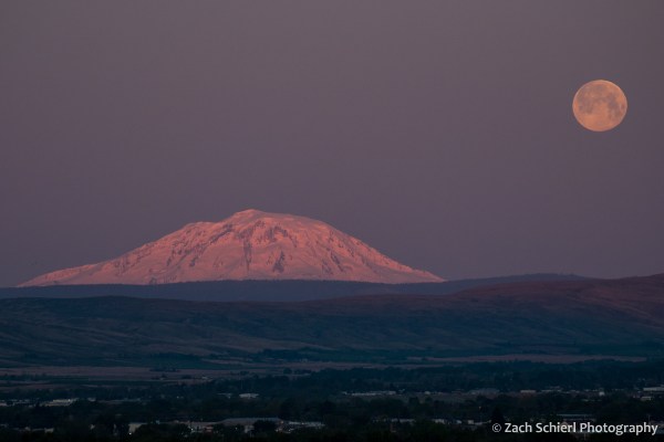
A nearly full moon rises over the forests of the Cascade Mountains.
After this trip and our stunning view of Mt. Adams a few weeks ago, our goal for the summer is now to camp in the shadow of all of Washington and northern Oregon’s stratovolcanoes. Next up: Mt. St. Helens!
Mt. Adams, Mosquitoes, and the Milky Way


Bright Jupiter rises above the summit of Mt. Adams, with the summer Milky Way reflected in the calm surface of Takhlakh Lake, Gifford Pinchot National Forest, Washington.
Mt. Adams is a striking feature of the western skyline from here in the Yakima Valley of Central Washington. Here’s what it looked like from our neighborhood at sunrise a few months back:
A setting full moon and sunrise light on Mt. Adams as seen from the Yakima Valley.
The towering volcanic cone looks close enough to touch, but in reality, reaching the base of Washington’s second highest peak requires a nearly three hour drive down a labyrinth of Forest Service roads. We’ve been wanting to explore the Mt. Adams area since we returned to Washington last year. With winter’s grip beginning to ease in the higher elevations of the Cascades, earlier this week we finally got the chance.
Mostly clear skies, calm wind, and a dark moon made for some great photo opportunities. While it may be debatable, I think some of these were worth their weight in mosquito bites. Several small ponds dot the lower flanks of Mt. Adams and snowdrifts still lingered in the shadier patches of forest, making the entire landscape somewhat damp. Consequently, the mosquitoes were ferocious! Sadly, our mosquito “repellent” only seemed to attract more. I was quickly reminded that a vastly underrated aspect of living in the southwest is the lack of bugs!

Mt. Adams reflected in Takhlakh Lake, Gifford Pinchot National Forest, Washington. (Not pictured: immense swarms of mosquitoes.)
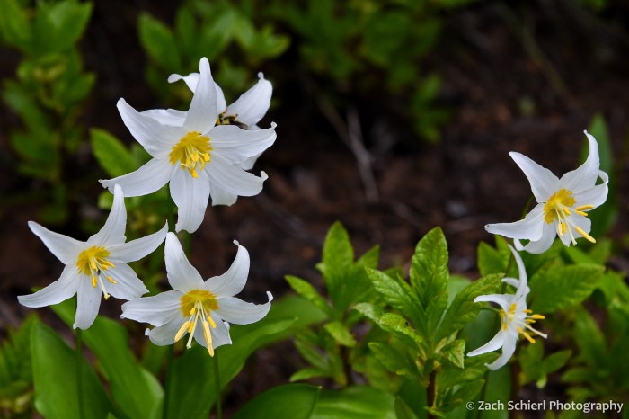
White avalanche lily (Erythronium montanum), one of the first wildflowers to emerge from the swampy ground as the snow melts away.

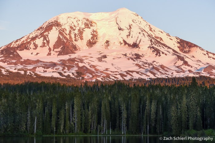
Mt. Adams reflected in Takhlakh Lake at sunset.
The forests just to the west of Mt. Adams happen to be located nearly in the center of the four large active stratovolcanoes of the south Cascades: Mt. Adams, Mt. Rainier to the north, Mt. St. Helens to the west, and Mt. Hood just across the Columbia River to the south in Oregon. A variety of relatively short but steep hikes in the area ascend lesser peaks, resulting in fantastic views of all four volcanoes, plus the dense forests of the Cascades:
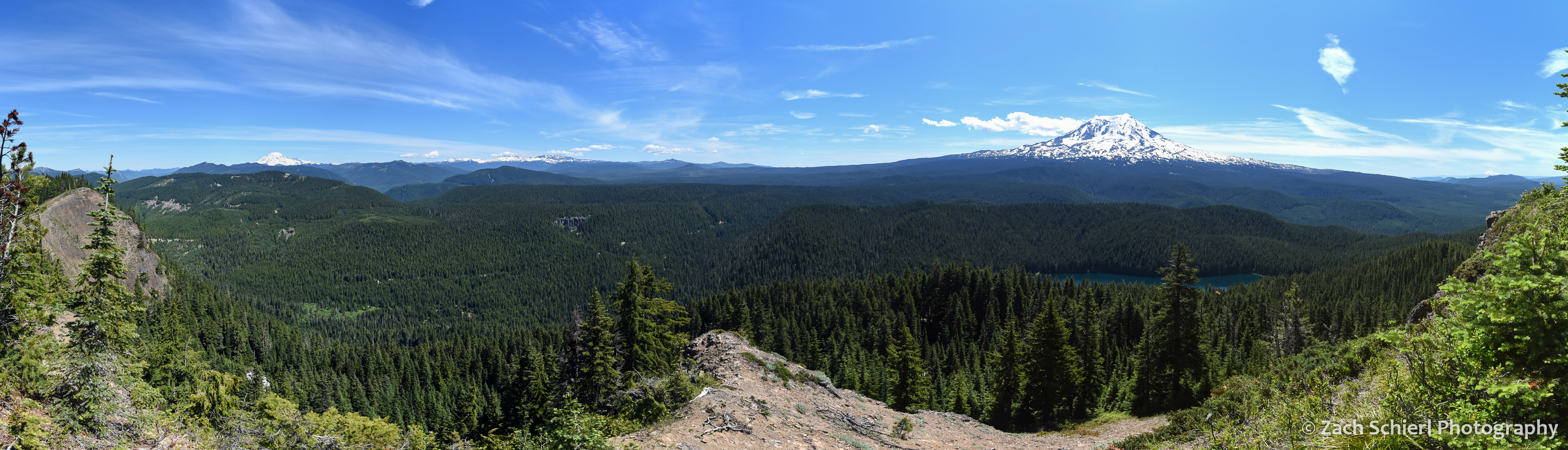
Panorama from Council Bluffs. Three Cascade Range stratovolcanoes (and the remains of a fourth) are visible (click to enlarge): Mt. Rainier (far left), the remains of the Goat Rocks volcano (center left), Mt. Adams (right), and Mt. Hood (far right). The upper portion of Mt. St. Helens’ eviscerated cone was also visible through the trees to the west.

The dense forests on the west flanks of Mt. Adams. Council Lake at bottom.
The real fun came after nightfall. Dark skies are much harder to find in Washington than in Utah, and this was my first good look at the Milky Way since last summer. The calm weather allowed me to capture the Milky Way’s reflection in Takhlakh Lake. Jupiter was kind enough to rise directly above the summit of Mt. Adams. And I got lucky and captured the brightest meteor of the evening in one exposure. This was certainly a case of being in the right place at the right time! (One might argue that the “right time” would have been a few months from now, when all the mosquitoes are dead, but then the Milky Way would not have been positioned so perfectly.)

A meteor takes aim at Jupiter as Mt. Adams and the Milky Way are reflected in Takhlakh Lake.

The Milky Way begins to emerge from evening twilight.
