Down the Staircase
Some photos from a week exploring southern Utah, Bryce Canyon, and the Grand Staircase:

Horseshoe Bend of the Colorado River. 4-shot panorama. Given that it was about 110 when I took this, I can't even describe how appealing that water looked...

The infamous murderer of Glen Canyon, a.k.a: Glen Canyon Dam, Colorado River

Peakaboo Trail, Bryce Canyon National Park

Summer Milky Way from Rainbow Point, Bryce Canyon National Park

Kodachrome Basin, near Cannonville, UT

The Toadstools, Grand Staircase-Escalante National Monument

Toadstool. Yours truly for scale.

Toadstool close-up. Basically the orange sandstone of the Entrada Formation (same stuff that forms the famous spans of Arches National Park) is easily erodible but portions get protected by boulders of the harder and more resistant Dakota Sandstone that originate in the cliffs above.

The Toadstools, Grand Staircase-Escalante National Monument
Sleeping with the spiders
Recently returned from a 4-day unofficial geology field trip (read: glorified sightseeing trip on which we occasionally talked about rocks) in which we managed to pretty much circumnavigate the entire South Island of New Zealand. Most of our time was spent along the west coast (the “wet side” of the island so to speak) and in Abel Tasman and Kahurangi National Parks. It rained pretty much the whole time and the humidity was so high for so long that some of the inner lens elements on my camera fogged up on day 2 and still haven’t completely dried out yet. I had a second little point and shoot camera with me but more often than not it decided that it wanted to tell me that the batteries were dead even when I had just put fresh ones in which was incensing to say the least. Ultimately, not the most productive trip photography wise but we got to see some amazing, off the beaten path places that I never would have even known existed were it not for the leadership of one of the Otago geology professors. Among the highlights were:
Oparara Basin, Kahurangi National Park:
Caves, arches, sinkholes, and tunnels were definitely the theme of the trip. We slept in them, hiked to them, hiked through them, attempted to avoid falling into them, and much much more. The Oparara Basin is home to a number of caves, many of which are infested with two lovely creatures: the Nelson cave spider (think tarantula only larger and skinnier) and the cave weta (think giant mutant cricket). Both of these fall into the category of “things you want to pretend don’t exist in the cave where you are trying to fall asleep”. However, given that the spiders hunt the weta, and that the weta emit a rather bizarre shrieking cricket-like noise when caught by the spiders, this is easier said than done. On the bright side, the cave was dry whereas there was a pretty legit thunderstorm going on outside that even ended up spawning a bunch of little tornadoes a couple hours away from us so in hindsight the cave was probably a good call.
In the morning we hiked through a torrential downpour to reach to very photogenic caves/tunnels along the Oparara River, both of which are surrounded by magnificent, dense rainforests. The larger of the two, Oparara Arch is a tunnel over 200 meters long and 50 meters high:

Oparara Arch
A few km downstream is the smaller Moria Gate Arch:

The Oparara River flowing through Moria Gate Arch
Kahurangi National Park is the second largest national park in New Zealand but one of the lest developed and most remote. There are no paved roads within the park and we didn’t see another soul during our entire time here.
Harwood’s Hole:
Another limestone sinkhole, Harwood’s Hole is no run-of-the-mill sinkhole; it’s nearly 1200 feet deep but only 150 feet wide. Standing on the edge, you can’t even begin to comprehend how large it is because even from a ledge halfway down, you can’t even see the bottom. Sadly we did not possess the equipment necessary to descend into New Zealand’s deepest cave (no one did until the late 1950’s…) so we were forced to settle for this view from the rim:

10 frame composite image of Harwood's Hole
Wharariki Beach:
Wharariki Beach is the most northern beach on the South Island that is open to the public and not closed off as a bird sanctuary. It’s definitely one of the coolest beaches I’ve seen, with tons of caves, arches, and sea stacks along the coast and an impressive sea of sand dunes just inland.

Wharariki Beach and Dunes

Saltation in action!
On the day we visited it happened to be rather windy and when I say rather I mean you could lean your body back at a 45 degree angle into the wind and be completely supported. There were times when the wind was so strong that you literally could not move forward if you were walking into the wind. The seals didn’t seem to mind though:
The Best Day Hike in the World
At least that how the Kiwi’s promote the Tongariro Alpine Crossing in Tongariro National Park. Given that I haven’t expereinced the vast majority of the day hikes in the world, I am not in a position to judge the accuracy of such a statement, however after last week I can say with certainity that you would have a very difficult time arguing against them.
The Tongariro Crossing is located in the central portion of Tongariro National Park, New Zealand’s oldest. The 19.4 km (12.0 mile) track climbs up and over a saddle between Mt. Ngauruhoe and Mt. Tongariro, two active stratovolcanoes that along with Mt. Ruapehu form the backbone of the national park and are the highest points on the North Island of New Zealand. If there is one thing that the trail is known for, it’s bad weather. The trail had been closed for most of the week that we were on the North Island due to snow and 120+ km/hr winds but on the last day of the trip, the clouds parted, the winds moved on, and we had 100% perfect weather for the entire day.
Undertaking the Crossing involves taking a shuttle bus to a trailhead on the west side of the mountains. 19.4 km later, the bus picks you up on the north side and drives you back to the carpark. From the very beginning, the landscape is incredibly stark, with almost no vegetation. Mt. Ngauruhoe (which played the role of Mt. Doom/Mordor in the Lord of the Rings Trilogy) looms above you for the entire first half of the hike. In many ways, the landscape is similar to what you would experience hiking across the flanks of Kilauea or Mauna Loa in Hawaii only much more mountainous. All three of the volcanoes in the part have expereinced significant eruptions in the last few decades and the trail crosses a number of fresh lava flows, pyroclastic deposits, craters, and steaming ground.
The trail begins by slowly climbing up a broad glacial valley on the western flank of the mountains. After about 8 kilometers and a 750m (2500 ft) climb up Devil’s Staircase (brief side rant: “Devil’s” is an prefix used FAR too often when it comes to naming moderately challenging sections of trail. Go hiking anywhere in the world and I promise you you will encounter a difficult section of trail named Devil’s Staircase, Devils’s Highway, Devil’s Ladder, or Camino del Diablo or something like that. I really want to know how these conversations go. “Ooh, this here trail is pretty steep…what should we call it?” “I dunno, whatever we call it though we should probably slap “Devil’s” on the front of it to make it sound nice and foreboding.” I mean, I get that its steep and you might be a little winded when you reach the summit, but in all honesty, unless you are trying to climb Everest in 120 degree heat with no oxygen, I have a feeling the Devil could assign you far more hellish tasks.) , we arrived at Red Crater, the highest point on the main trail. Side trails split off the main route and head to the summits of Mt. Ngauruhoe and Mt. Tongariro. Since we had gotten a late start, we chose Mt. Tongariro since it was shorter and didn’t involve scrambling up a 45 degree scree slope. The views from the top were breathtaking, one could see almost from one coast of the island to the other. After Red Crater, the trail descends sharply down to Emerald Lakes past a number of hydrothermal vents and pools and lots of steaming ground. The second half of the trail basically just heads straight down the mountain and is relatively unremarkable. We ended up running the last few km’s in order to catch the 3:30 bus back to our car and not have to wait for a hour to catch the next one.
All in all, an amazing hike, especially for the geologically inclined. My only complaint were the hundreds of other people we shared the trail with. This was to be expected I suppose given that this was the first day in a week that the trail had actually been passable but it was still far from what you would call a wilderness experience. Despite the length and elevation gain, the crossing is not a particularly difficult trail. With the exception of one stretch just after Red Crater, the trail is incredibly well maintained and the footing is superb. We manged to complete the trail in exactly 7 hours including our side trip to Tongariro Summit.
-
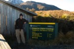
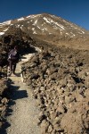
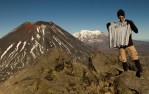
- Yours truly at the trailhead
-
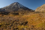
- Looking up towards Mt. Ngauruhoe from the beginning of the Tongariro Alpine Crossing
-
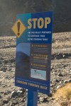
- The DOC makes a BIG effort to make sure that people attempting this trail are prepared and have the right equipment. In fact, a few years back, they actually changed the official name of the trail from “Tongariro Crossing” to “Tongariro Alpine Crossing” in an attempt to make the trail sound more inhospitable to novice hikers.
-
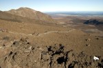
- Trekking across Mordor…
-
- Devil’s Staircase, Tongariro Alpine Crossing
-

- Needle ice on Mt. Tongariro
-

- Layered, hydrothermally altered volcanic deposits dot the foreground, Mt. Ngarahoe visible in the background from Mt. Tongariro
-

- Early season snow on Ngauruhoe, as seen from Red Crater
-
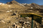
- Trail Junction on the Tongariro Alpine Crossing
-
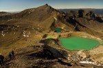
- Emerald Lakes on the Tongariro Alpine Crossing
-

- A distant, hazy view of Mt. Taranaki (all the way on the west coast of the North Island) from the summit of Mt. Tongariro
-
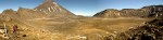
- Panorama of South Crater between Mt. Ngauruhoe and Mt. Tongariro
-
- Represent!!!
