Exploring the Earth and Sky of the West

Latest

The Bioluminescent Bay of Islands

Writing a blog entry about spending several days in New Zealand’s equivalent of Hawaii is a bit emotionally trying when its been raining pretty much non-stop here in Dunedin for the past week.  In the interest of my loving readers though, I shall bravely attempt to press on.  Good thing this is written on a computer screen otherwise the copious teardrops would likely render my handwriting even more illegible than usual.

Let me introduce the Bay of Islands:

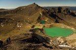
Panorama from the summit of Waewaetorea Island

Pretty, yes?  The Bay of Islands was the only destination we had reservations for prior to the trip so the first half of our journey was scheduled around being there on Tuesday in order to go on an overnight exploration around the Bay on a ship called The Rock.  We arrived in Pahia, the only town of significant size in the area, on Monday night in some of the heaviest rain I’ve ever seen. We had been intending to camp, but the rain and wind was bad enough to make even Jim Cantore squirm so we ended up pursing alternative accommodations.  We briefly got excited about the prospect of staying at  a hostel with a pet parrot but we ended up negotiating a cheaper rate elsewhere.

In a reflection of the good fortune we experienced throughout the trip, by morning the weather had cleared and our concerns that the cruise we had planned our trip around would be canceled were abated.  We spent the morning exploring Pahia, which essentially consisted of walking up and down two streets, wandering along the beach, and attempting to mask our pasty white skin tones that betrayed our South Island origins.  While a pleasant enough town, Pahia was easily the most touristy place I’d been in New Zealand so far (note: this all changed when we went through Rotorua later in the trip…).  Once of the things that I’ve really enjoyed about traveling around New Zealand so far is the (relative) lack of commercial exploitation of the country’s major attractions compared to the US.  Even though I’ve been here at the tail end of high-season, most of the places I’ve been have been delightfully non-crowded and in many places, finding so much as a single gift shop has been difficult.  Not so in Pahia.  Tacky souvenir shops and gaudy “EXPERIENCE NATURE AT IT’S FINEST! SWIM WITH DOLPHINS AND WHALES!!!” signs and banners advertising cruised on multimillion dollar, noisy jetboats were everywhere.

Late in the afternoon, we headed down to the wharf where we were shuttled out to The Rock on a old, slightly sketchy motorboat named the Climax (for reasons which will not be elaborated upon here).  The Rock is a two story former vehicle ferry that was converted into essentially a floating hostel a few decades back.  The upper deck consisted of bedrooms and dorms for up to 30 people while the main deck was a kitchen, lounge, bar, and general hang-out area.  The first evening on the boat consisted of getting to know the other passengers, fishing for snapper off the back end (ahem…stern) of the boat, watching our friend eat the still beating heart of the fish we caught for dinner, a delicious steak and snapper dinner, and in one of the highlights of the trip, night kayaking around the bay.

Approaching the Rock

Onboard the Rock

The excitement in the kayaking did not lie in the kayaking itself but in what was living in the ocean.  The waters around the Bay of Islands are abnormally clear and also happen to be home to a organism known as Noctiluca scintillans, a plankton like creature that absorbs sunlight during the day, and, due to chemical reactions of which I do not know the precise details, emit shimmering blue light when disturbed after dark.  This phenomenon is generically known as bioluminescence and if you take a long exposure photograph of the Noctiluca, they look like this.  (needless to say I was killing myself for not bringing a tripod…)  The “disturbing” in our case was kayak paddles.  With every stroke of the paddle you were rewarded with a quick flash of glittering blue light alongside the boat.  Jumping off the boat into the water was even more impressive.  It was seriously one of the coolest, and yet most bizarre things I’ve ever seen in my life.

View from the back of the boat at sunset

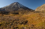
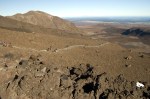
Day 2 on The Rock was packed with more fun activities.  First thing in the morning we spent about an hour or so snorkeling along the coast of one of the islands for kina, a common and extremely spiny type of sea urchin that was to become part of our lunch later on.  After the snorkeling, we headed over to  Waewaetorea Island, upon which we were the only inhabitants for the next several hours.  Climbing up to the summit of the island offered an absolutely phenomenal panoramic view of the Bay of Islands, which interestingly was one of the first places in New Zealand to be inhabited by the native Maori coming from Polynesia, and also the location of the first European settlements in New Zealand in the late 1700’s.  I would have had absolutely no objections to staying on this island for the rest of the trip, active volcanoes and other attractions be damned.  The weather here was probably the best I’ve experienced during my time in New Zealand, 75-80 degrees and hardly any clouds in the sky.

The delicious innards of the humble kina

As far as I can recall, the 22 or so hours we spent on the Rock was the longest period of time I’d ever spent on a boat in my life.  While I was strongly in favor of stowing away in the engine room, my traveling companions kindly reminded me that if I stayed on the boat, there would be no one to drive the rental car.  Alas, we returned to Pahia in the afternoon to proceed with the rest of our trip.

And thus concludes this blog entry. I’m going to go back to freaking out about the fact that I only have slightly more than a month left here now…adios!

Beach on Waewaetorea Island

The Best Day Hike in the World

At least that how the Kiwi’s promote the Tongariro Alpine Crossing in Tongariro National Park. Given that I haven’t expereinced the vast majority of the day hikes in the world, I am not in a position to judge the accuracy of such a statement, however after last week I can say with certainity that you would have a very difficult time arguing against them.

The Tongariro Crossing is located in the central portion of Tongariro National Park, New Zealand’s oldest.  The 19.4 km (12.0 mile) track climbs up and over a saddle between Mt. Ngauruhoe and Mt. Tongariro, two active stratovolcanoes that along with Mt. Ruapehu form the backbone of the national park and are the highest points on the North Island of New Zealand.  If there is one thing that the trail is known for, it’s bad weather.  The trail had been closed for most of the week that we were on the North Island due to snow and 120+ km/hr winds but on the last day of the trip, the clouds parted, the winds moved on, and we had 100% perfect weather for the entire day.

Undertaking the Crossing involves taking a shuttle bus to a trailhead on the west side of the mountains.  19.4 km later, the bus picks you up on the north side and drives you back to the carpark.  From the very beginning, the landscape is incredibly stark, with almost no vegetation.  Mt. Ngauruhoe (which played the role of Mt. Doom/Mordor in the Lord of the Rings Trilogy) looms above you for the entire first half of the hike.  In many ways, the landscape is similar to what you would experience hiking across the flanks of Kilauea or Mauna Loa in Hawaii only much more mountainous.  All three of the volcanoes in the part have expereinced significant eruptions in the last few decades and the trail crosses a number of fresh lava flows, pyroclastic deposits, craters, and steaming ground.

The trail begins by slowly climbing up a broad glacial valley on the western flank of the mountains. After about 8 kilometers and a 750m (2500 ft) climb up Devil’s Staircase (brief side rant: “Devil’s” is an prefix used FAR too often when it comes to naming moderately challenging sections of trail.  Go hiking anywhere in the world and I promise you you will encounter a difficult section of trail named Devil’s Staircase, Devils’s Highway, Devil’s Ladder, or Camino del Diablo or something like that.  I really want to know how these conversations go.  “Ooh, this here trail is pretty steep…what should we call it?”  “I dunno, whatever we call it though we should probably slap “Devil’s” on the front of it to make it sound nice and foreboding.”  I mean, I get that its steep and you might be a little winded when you reach the summit, but in all honesty, unless you are trying to climb Everest in 120 degree heat with no oxygen, I have a feeling the Devil could assign you far more hellish tasks.) , we arrived at Red Crater, the highest point on the main trail.  Side trails split off the main route and head to the summits of Mt. Ngauruhoe and Mt. Tongariro.  Since we had gotten a late start, we chose Mt. Tongariro since it was shorter and didn’t involve scrambling up a 45 degree scree slope. The views from the top were breathtaking, one could see almost from one coast of the island to the other.  After Red Crater, the trail descends sharply down to Emerald Lakes past a number of hydrothermal vents and pools and lots of steaming ground.  The second half of the trail basically just heads straight down the mountain and is relatively unremarkable.  We ended up running the last few km’s in order to catch the 3:30 bus back to our car and not have to wait for a hour to catch the next one.

All in all, an amazing hike, especially for the geologically inclined.  My only complaint were the hundreds of other people we shared the trail with.  This was to be expected I suppose given that this was the first day in a week that the trail had actually been passable but it was still far from what you would call a wilderness experience.  Despite the length and elevation gain, the crossing is not a particularly difficult trail.  With the exception of one stretch just after Red Crater, the trail is incredibly well maintained and the footing is superb.  We manged to complete the trail in exactly 7 hours including our side trip to Tongariro Summit.

A Visit to Aoraki

Oh boy where to begin. I suppose the beginning would probably be a good place to start.  Went with a group of five other people to Mt. Cook this past weekend to do some camping, backpacking, and other touristy type things.  Known by the Māori as Aoraki, visiting the Mt. Cook area has been solidly atop my “to do” list ever since I found out I was going to be coming to New Zealand for a semester (another guy our group has had a picture of Mt. Cook as his desktop background for the last year) so my excitement level was off the charts for the past week or so.  Mt. Cook is about a 4.5 hour drive from Dunedin so we rented a Toyota Previa (didn’t know they still made those…) and I got to continue acclimatizing to driving on the left side of the road.  I was the only driver on a trip to Milford Sound a few weeks ago (blog entry on that to come at some point…) and only almost got us killed once so I was feeling pretty confident heading into this weekend.  Honestly, it’s become so natural that I know its going to be weird to come back to the states in a few months and get back into the right hand lane.

We didn’t have real specific plans for the weekend as the weather at Mt. Cook is notoriously nasty year-round.  Snow and hurricane force winds are commonplace even in the summer and we decided that we would pretty much let the weather dictate when and where we hiked.  Our main goal though was to spend a night at the famed Mueller Hut on Mt. Ollivier just across the valley from Mt. Sefton and Mt. Cook, the highest point in New Zealand and Australasia at 12,316 ft.

The weather upon our arrival on Thursday night was not particularly reassuring.  The campground was located near Mt. Cook Village right at the mouth of the glacial valley that leads up into the mountains.  This valley apparently is very good at funneling rain and wind right down into the valley because even though the skies at the campground were almost completely clear, we had the pleasure of setting up our tents in a downpour that was literally coming at us from the side. My little two person tent went up pretty easily however the large 4-person dome tent that we rented from the school was about as aerodynamic as a tank.  Compound this with the fact that this tent had a pole setup that was analogous to solving a Rubik’s Cube and the inside was pretty much a lake by the time we finally got it up.

Fortunately the weather had cleared by morning.  I was the first one out of the tents in the morning and while I won’t repeat my exact words upon seeing the surroundings of our campsite here, suffice to say they it was pretty spectacular.

Mt. Sefton at sunrise from the campground.

Since the weather was looking promising for the day, we hightailed it over to the DOC (Department of Conservation, essentially the New Zealand equivalent of the National Park Service) Visitor Center to make reservations for a night at Mueller Hut.  The hut sleeps less than 30 people and is first come first served so we wanted to be there early.  Because of the terrain and weather, the DOC at Mt. Cook is understandably strict about making sure all hikers check in with the rangers to inform them of their plans and itinerary.  After getting our permit and having a quick breakfast, we shouldered our packs and started up the trail to the hut.

Note that the word “trail” in this context is used a bit loosely.  The DOC officially calls it the “Mueller Hut Route” which I think conveys things a bit better.  The trail up to the hut is a deceptively short 2.7 miles.  However, in those 2.7 miles, one gains over 3500 feet in elevation for an average elevation gain of about 1300 feet per mile. For comparison, the Bright Angel trail in the Grand Canyon averages about 540 feet of elevation change per mile.  In summary, the Mueller Hut Route is one of those trails where you talk not about “miles per hour” but rather “hours per mile”.  The first half of the trail is relatively well maintained although it consists mostly of crude railroad tie “stairs” implanted in the side of the mountain.  The second half of the trail is marked only by intermittent orange posts and traverses a nasty talus/scree slope where footing is pretty much non-existant.  We made it up to the hut in about 6 hours.

The "trail" about 0.5 km east of Mueller Hut

View from the Mueller Hut route looking back down the valley. The campground where we stayed is just left of center. Mt. Cook Village is the cluster of buildings at the base of the greenery on the right. Lake Pukaki just visible on the horizon.

The setting of the hut was absolutely indescribable.  Rather than trying, I’ll show you a picture instead:

A view of Mueller Hut from Mt. Ollivier. Mt. Cook partially hidden by clouds at upper right.

We arrived at the hut mid-afternoon so we had plenty of time to hang out around the hut, meeting other hikers and exploring the area.  One of the coolest things was witnessing the nearly continuous icefalls that occur on the glaciers that coat Mt. Sefton.  Large avalanches of ice cascading down the sheer face of a mountain sounds remarkably like thunder and the sound travels so far and well that even at our campsite in the valley, miles away fro the ice, I was still woken up several times by the roar of the icefalls.  In the afternoon, 4 of us scrambled up to the top of Mt. Ollivier, the first peak a young Sir Edmund Hillary (the first man to climb Mt. Everest) climbed back in 1939.

Mt. Cook with the terminus of the Hooker Glacier just below it.

The Mueller Hut that we stayed in is actually the fifth-incarnation of  the hut.  First built in 1914, Mueller Hut has been swept away by avalanches on several occasions (The second hut lasted just 4 months before it was swept away…) and the weather conditions are so downright awful that the hut requires rebuilding on a regular basis.   The current hut has been in place since 2003 when it was opened by Sir Edmund Hillary himself.  By normal backpacking standards, the hut was a five-star resort.  It has large tanks of running water outside on the deck, gas stoves, some fairly comfortable mattress pad thingys in the dormitory-style bunkhouse, and even indoor bathrooms in a outhouse about 50 yards from the main building.  The hut is managed in the high season by volunteer hut wardens that stay for a week at a time.  Every night at 7pm, the hut gets a radio call from Mt. Cook base in the village below to inform the hut wardens of the weather forecast for the coming day as well as to confirm that everyone made it up to the hut safe and sound for the night.

The whole crew on the hut deck at sunset

Perhaps the most spectacular part about staying at the hut was what it looked like after dark. Being over 100km from any significant sources of light pollution, the night sky at Mt. Cook is accordingly spectacular.  We lucked out in the fact that our visit coincided with a nearly New Moon so the skies were dark. Real dark.  Literally, you almost didn’t need a flashlight to walk around after dark, the sheer volume of starlight was sufficient enough for me to confidently walk back to the hut without fear of falling into a rock crevasse.  Sunrise the next morning (first time I have willing gotten up before 7am in a LONG time…) was equally spectacular although the winds has increased dramatically by morning.

Mueller Hut and Mt. Sefton at dawn.

The climb down the next morning was much more pleasant on the cardiovascular system although a bit rougher on the knees and calves.  Once we got back to camp (where we had gladly swallowed the extra $6 per person to keep our tents set up for the night we were at the Hut just so we didn’t have to spend another hour setting them up in the rain and wind) we pretty much just lounged around the rest of the day, exploring Mt. Cook Village and driving up the Tasman Valley to look at some more glaciers. Our last night at the campground was a rather sleepless one due to the winds which magically reappeared after dark.  I must say though, even after only a few uses, I am extremely impressed with my new Mountain Hardware Drifter 2 tent (Thanks Mom and Dad!).  The thing is waterproof as a submarine and even though what is supposed to be the ceiling of the tent was in my face most of the night, it didn’t bend or break despite the extreme winds.  Overall, we all felt exceedingly elated that the weather once again cooperated for the most part.  At this point, I can confidently say that I have brought the sunny Arizona weather with me to New Zealand because every weekend it feels like I go somewhere where the weather is notoriously abysmal only to have the sun shine almost all the time.

May the weather gods continue to smile!

The summit of Mt. Cook at sunset