Europe Part 7: Into the Albanian Alps

Links to previous posts: Part 1, Part 2, Part 3, Part 4, Part 5, Part 6
Albania wasn’t on our itinerary when we first sketched out this trip four years ago. Our flight back to North America would be departing from Rome, so we needed to get across the Adriatic Sea to Italy at some point. We didn’t want to retrace our steps back to Zagreb or Ljubljana, so we initially thought about continuing south to Greece and flying back to Rome from Athens. At some point during our trip planning though, we ran across some YouTube videos of people backpacking in the Albanian Alps and pretty quickly decided that we wanted to fit them into our itinerary. Plus we found some cheap flights from Tirana (Albania’s capital) to Rome, so Albania it was!
Albania is a fascinating nation with a history that sets it apart from the surrounding countries that we visited. The only country on our trip not part of the former Yugoslavia, Albania experienced a more isolating and brutal form of communism than its Yugoslav neighbors to the north. From 1944 to 1985, Albania was controlled by the dictator Enver Hoxha, and was almost entirely isolated from the international community, unlike the relatively open Yugoslavia. Communism fell in Albania in the early 1990s, and today it is a democracy, albeit a fledgling one. Arriving in Albania was definitely a little bit of a culture shock, even after almost a month of travelling. After three weeks of seeing Serbo-Croatian languages everywhere, we knew or at least recognized a lot of words so it was becoming a bit more familiar. Albanian is completely different, so it was sort of like starting the trip all over again. English was also widely spoken in the former Yugoslav republics (I swear the Slovenians spoke English better than we do…) but this was definitely not the case in Albania, especially in the more rural parts. There exists only a single guidebook for Albania, and overall it was much harder to find information and plan things in advance.
After out brief stop in Shkoder, we embarked on the final leg of our trip: a five day tour through the rugged Albanian Alps, also known as the Accursed Mountains. Our plan was to take minibuses and a ferry to the Valbona Valley, stay there for two nights, then hike over Valbona Pass to the village of Theth, where we would spend a few more nights before taking another minibus back to Shkoder and eventually Tirana to begin our journey home. While we were already travelling pretty light, we would need to carry all of our belongings with us over Valbona Pass so we ended up leaving some stuff behind at our hotel in Shkoder and picking it up on our way back through five days later.
We departed at 6:30 am on a minibus, the primary mode of public transportation in Albania. The minibus drove around Shkoder for close to an hour picking up other people until the bus was full, then we headed out of town and quickly started climbing up into the mountains. Our destination was the Komani Lake ferry terminal. The Valbona Valley, while not far from Shkoder as the crow flies, is not easy to get to. One option is an all day drive that apparently involves crossing the border into Kosovo and then back into Albania. Option 2 involves a two-hour drive to Komani Lake, followed by a 3-hour ferry ride, and then another minibus for the final hour to Valbona. We opted for the latter and a few hours after departure from Shkoder arrived in the tiny and very rural town of Komani. From here, the road, which had been very rough dirt for the last hour, was suddenly paved and lined with a sidewalk and streetlights. The road climbed up a steep grade littered with rockfall before entering a small tunnel bored into the side of the mountain. About halfway through the tunnel, cars and buses were stopped in the road letting people out. Our bus somehow managed to squeeze past a bunch of them (if you had asked me whether this tunnel was wide enough for two mini buses to pass each other, I would have said “hell no”), but eventually had to stop as well. We got out of the bus, grabbed our stuff, and walked out through the end of the tunnel, which emerges at the base of a huge cliff next to a ~30×30 foot patch of pavement wedged between the cliff face and the shoreline of Lake Komani, which is actually a reservoir.

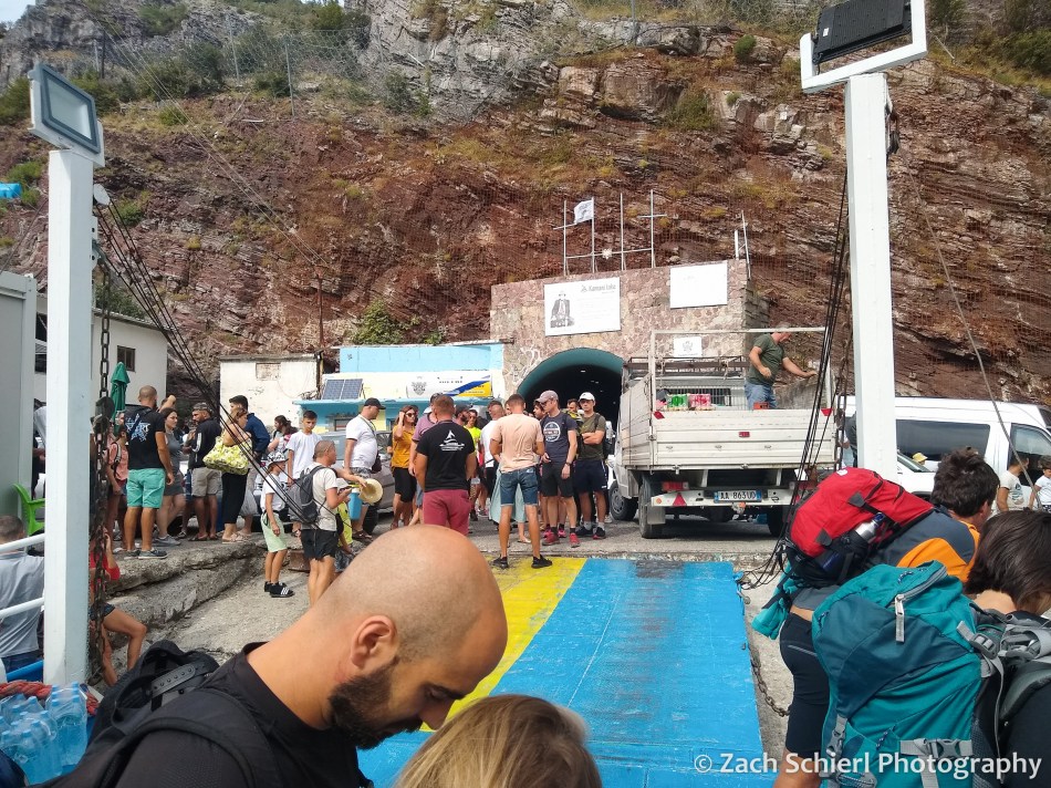
This was the ferry terminal and it was absolute chaos…probably the craziest scene I have experienced while travelling. It was jam packed with people, minibuses, full size buses, luggage, cars and trucks trying to get on (or off) one of more than a dozen boats of various sizes that were jostling for space along the shore. It was pretty wild. We pushed our way forward to the largest boat, Ferry Berisha (fun fact: named for a former prime minister and president of Albania who was banned from entering the U.S. in 2021 because of “involvement in significant corruption”), on which we had, in theory, paid for the trip in advance. The ferry employees didn’t seem to have any record of that though, and after a few minutes of trying to translate our argument into Albanian, they just let us on, probably just to keep the line moving more than anything else. The ferry was relatively small, with about 10 cars on the lower deck and a small passenger deck above with seats. The passenger seats were already quite full by the time we boarded so we ended up plopping down on the lower deck next to the cars. We estimated that there were well over a hundred people on the ferry and were somewhat surprised to see so many people headed to such a remote part of Albania. I guess we shouldn’t have been…after all, we found out about this area from a YouTube video. Mass tourism spares no corner of the world these days.
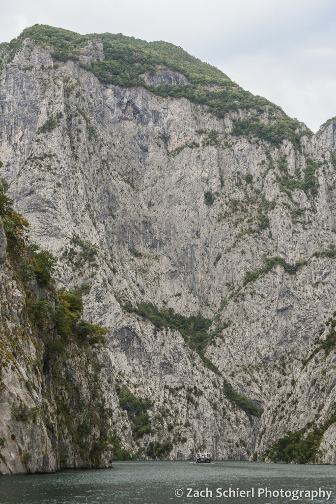
The ferry ride was very scenic, and reminded me a lot of the Black Canyon of the Gunnison in Colorado (specifically the Morrow Point Reservoir section where the National Park Service runs a boat tour.) Komani Lake is a very narrow reservoir that winds deeper and deeper into the Albanian Alps, with several thousand foot cliffs coming right down to the water in many spots. There were a number of small villages and houses along the shores that are apparently accessed only via ferry.

The ferry terminal where we disembarked was not quite as chaotic. Basically there were just a ton of mini buses standing ready to shuttle people the last hour to Valbona. Neither of us remember the drive that clearly because we were both nodding off. We were eventually dropped off at Guesthouse Demushi, our home for the next two nights. The setting was gorgeous. The guesthouse was on a mini-farm with a garden, fruit trees, flowers, lots of chickens running about, and, of course, stunning views of the high peaks in the Albanian Alps.

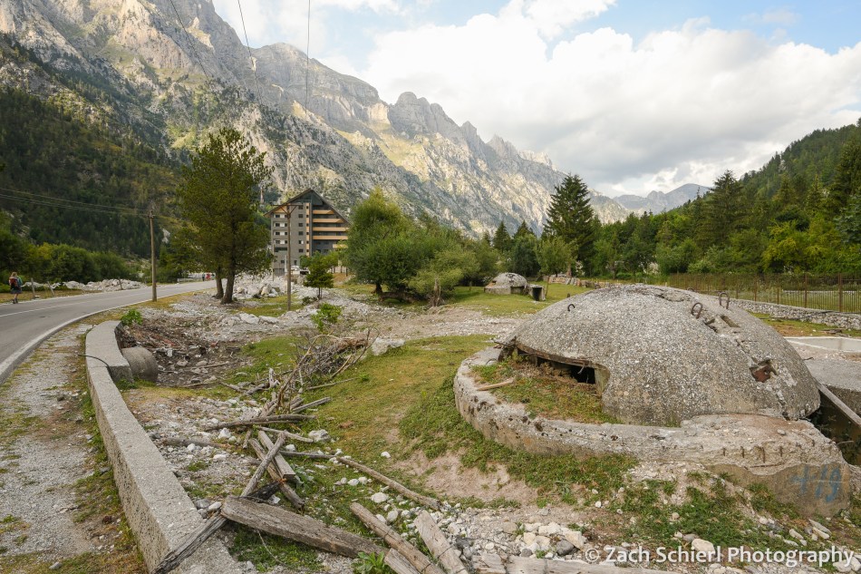
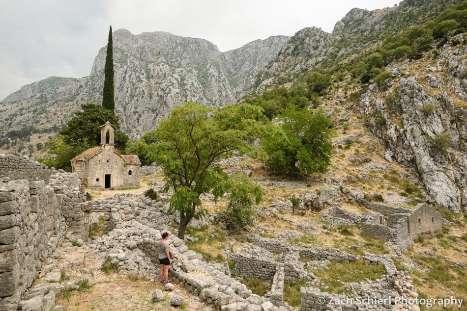
Valbona is not really a town per se, but rather a bunch of homes, farms, and guesthouses strung out along several miles of the Valbona River Valley. The road into the valley dead ended a few miles up valley from our guesthouse, turning into a hiking trail that we would take to Theth a few days later. Valbona was an incredibly beautiful albeit very perplexing place. We struggled to find a comparison to anywhere we’ve visited before. For starters, we weren’t quite sure where everyone that was on the ferry went, because the valley felt pretty deserted. There were a ton of little guesthouses (some with restaurants) scattered throughout the valley, but no other tourist infrastructure whatsoever: no stores, gas stations…nothing. The entire area is a national park, though if we hadn’t read that in advance, I don’t think we would have known. There is certainly no visitor center, and barely any signage whatsoever. It seemed like half the valley was under construction. There were a lot of half finished buildings (including a monstrosity of a hotel that seemed more out of place than any building I’ve seen in my life), many of which looked like they hadn’t been worked on in quite some time. The roadside and yards were also littered with decomposing, round, concrete bunkers, left over from Albania’s communist days when Enver Hoxha was paranoid about an attack and had several hundred thousand prefabricated bunkers built across the country. Sadly, there was also a ton of trash everywhere. It sort of felt like someone decided to build a little mountain resort town and then just abandoned the project halfway through. All in all, the built environment felt wildly incongruous with the natural setting.

The Valbona Valley is in extreme northern Albania, just a few miles from Montenegro and a few miles from Kosovo. After getting our bearings, we were excited to do some hiking the following day, however we struggled to find reliable information on hiking trails in the area or a weather forecast. My CalTopo mapping app showed a handful of trails, but I’m always loathe to rely entirely on electronics, especially in an unfamiliar area. (Oddly, we had full LTE cell service throughout the valley.) We couldn’t find a paper map, because the only person in the valley who sold them has apparently disappeared from the face of the Earth (a story for another time…)
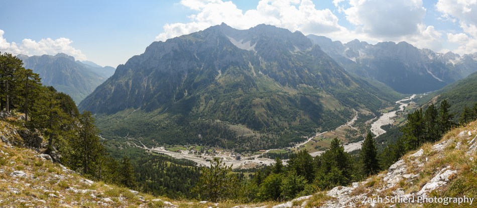
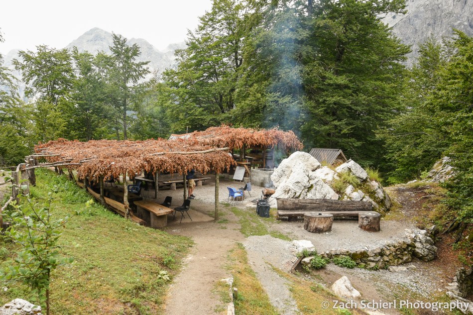
We ended up hiking a loop trail that a waiter had mentioned the night before at dinner, only part of which appeared on my digital map. The hike began with a gentle ascent to the village of Kukaj, perched a few hundred feet above the main valley in a little side drainage. From Kukaj, the hike got quite steep and we sweatily labored our way up the valley wall until we arrived at an amazing viewpoint where we could look both up and down the Valbona Valley. (See photo at top of post.) We spent close to an hour here enjoying the view before completing the loop and descending back to the valley floor. We got back the guesthouse not long before a pretty intense thunderstorm (and brief power outage) rolled through the valley.

The next day it was time to head across Valbona Pass to Theth! This day happened to be our 6th wedding anniversary, a date on which we’ve had some interesting adventures the last few years. In 2019 we rode a shuttle bus in Glacier National Park that ended with us filing a formal safety complaint with the National Park Service, then proceeded to nearly lose a wheel on our own car, necessitating a cross-border trip to a NAPA Auto Parts store in Cardston, Alberta. In 2020 we had a brush with hypothermia on a backpacking trip near Glacier Peak, only to return to our car and find that mice had trashed it during the few nights it was parked at the trailhead. In 2021 we were on a whitewater rafting trip on the Rogue River in Oregon, which actually went quite well save for the suffocating wildfire smoke that has become so common in late summer.
The day started with a delicious breakfast at Guesthouse Demushi, consisting of bread, butter, cheese, jam, eggs, etc…very traditional, tasty, and filling. After breakfast, we got a ride to the end of the paved road to save us a few miles of walking. We started early as we weren’t quite sure how long of a hike we had in store. Distance estimates we had seen online varied wildly, and while the route was well signed, like most other countries in Europe, Albanian trail signs give distances in hours, as opposed to, you know, an actual unit of distance like kilometers or miles. (As a former park ranger who has seen first hand the wide range in personal hiking speeds, this drives me crazy to no end!) Our best estimate was 8-10 miles.
It was a cool, overcast, and humid morning as we walked the mostly flat, gravelly river bottom for the first few miles to the village of Rragram. After Rragram, the grade started to steepen. While it was still overcast and fairly cool, it was extremely humid and I’m not sure if I’ve ever sweat so much in my life. Times like these make me grateful that we live in the desert! Before too long we arrived at one of two small cafes found along the trail. This has to be the ultimate paradox of hiking off the beaten path in Europe: it’s almost impossible to find out how long the trail actually is, but you can still buy a cold beer every few miles. Quite surreal. This first cafe had a thatched roof of leaves, a wide selection of cold drinks cooled by a natural spring, and a plush bathroom with an ornate running water system. (Prices for those drinks were the highest that we had seen since London, which I guess makes sense. Generally speaking, prices in Albania were quite low. Dinner for two with drinks set us back the equivalent of about $20 most nights. A soda here at the cafe was $5.) We enjoyed two sodas even though it was not yet 9 am, to replace the many electrolytes we had lost via sweat in the last two hours.
The trail from Valbona to Theth is without a doubt the most travelled in the Albanian Alps, but up until this point we had only seen one other group of people and were again starting to wonder where the heck everyone was. Apparently we were the early birds because while resting at the cafe, several larger groups caught up with us and we had plenty of company the rest of the day. After the cafe the hike got much more interesting as we began to ascend rocky slopes up toward the pass. The views really opened up and we could see back down the Valbona Valley towards where we had stayed the last few nights. Before we knew it, we were arriving at the pass, just as the clouds started to open up. Luckily we didn’t hear any thunder, but even so we didn’t stick around too long before beginning the descent to Theth. Half an hour later we arrived at cafe #2 where we waited out another heavy band of rain under a covered seating area while enjoying some fli, a traditional Albanian mountain pastry consisting of layers of Swedish-pancake-like dough with sugar and nuts.
From the second cafe it was a long, steep descent into Theth, mostly through dense beech forests with minimal views. In the final installment, more on Theth and our journey home!

Europe Part 6: Montenegro & the Bay of Kotor


From Mljet we took the ferry back to Dubrovnik and the mainland. The return journey was slightly less comfortable, as the ferry was overbooked. The few seats available were next to people who appeared to be seasick, so we ended up sitting in the stairwell for the majority of the 90 minute journey. From here we were headed for Kotor, a few hours south of Dubrovnik across the border in Montenegro. The drive from Dubrovnik to Kotor was supposed to be incredibly scenic, so we had booked a tour that would allow us to sightsee en route. Unfortunately our tour guide cancelled on us just a few hours before departure, so on the morning we departed Mljet, we suddenly found ourselves sans transportation to our next destination. Fortunately it wasn’t a long drive, so we were able to find a relatively affordable “transfer service” (basically a taxi) on very short notice.
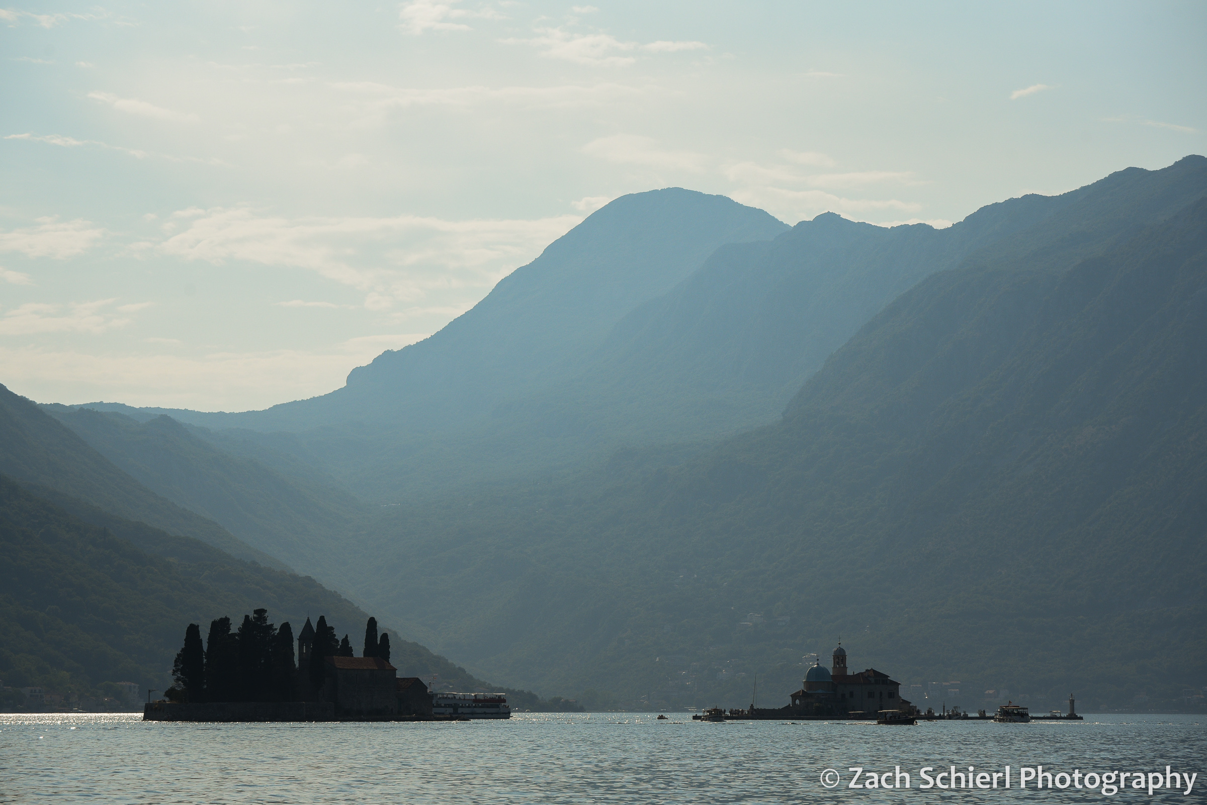
The scenery was just as beautiful as advertised. From Dubrovnik to Kotor, the highway follows the coast until the border between Croatia and Montenegro, then diverts inland to wind around the Bay of Kotor, a crazily-shaped inlet of the Adriatic Sea that cuts deep into the rugged mountains of Montenegro. We stopped in Herceg Novi (hometown of our wonderful driver, Dario) and Perast for about an hour each on the way. In Herceg Novi, we enjoyed a short walk around the old town, went up in the Ottoman-era fortress above town, and enjoyed a delicious lunch from a little bakery. In Perast, a smaller, more touristy town right on the bay, we saw some dolphins swimming in the bay (no photos sadly) and took a water taxi to “Our Lady of the Rocks” a small Catholic church on a tiny island a few hundred yards out into the bay.

The island and church are steeped in legend. Depending on the source, the story goes that, in 1452, some sailors were returning from a voyage, one of them with an injured leg. On their way home they discovered an icon of the Madonna and Child stuck in a coral reef or rock in the bay. They brought it to shore and the injured sailor was miraculously healed. As thanks, they vowed to build a church on the spot where they found the icon. They began dropping large rocks into the bay, and intentionally loading up boats with rocks to sink them, until a small island was formed. Eventually they built a church on the island and put the icon inside.
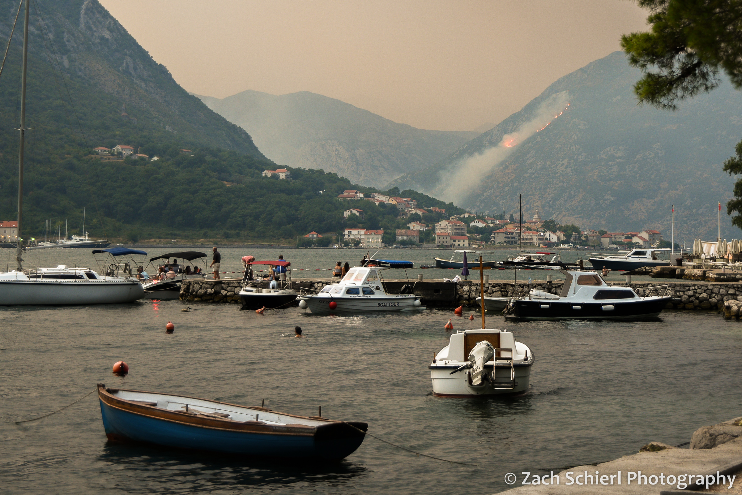
After a pleasant drive, we arrived in Kotor around dinner time to a somewhat ominous scene. The jagged mountains above Kotor are themselves quite imposing. Though made of the same limestone we saw earlier on the trip in the Julian Alps, here the rock is much darker, hence the name “Montenegro” (black mountain). There were also some pretty intense thunderstorms forming above the mountains, and to top it off there was a wildfire with large visible flames crawling up a mountain on the other side of the bay.
With this backdrop, we checked into our lodging, one of the more unique places we stayed on the trip: an apartment in a 16th century stone villa just a few steps from the water. The grounds of the villa were quite interesting, with several courtyards, gardens and a great waterfront view. The apartment was about a twenty minute walk from the old town of Kotor, which is basically a mini-Dubrovnik with its fortified city walls, dramatically wedged in between the bay and the mountains. In fact, the city walls of Kotor go straight up the side of the mountains behind town. They blend in with the rocks quite well, and are sort of hard to see during the day, but at night parts of the walls are lit up, making for a spectacular scene:

The following morning, our goal was to hike up to the top of the city walls where there is an old fortress that looks out over the bay and the city below. The walls are not in great shape: they are crumbling in many places and there is a ton of trash everywhere. (Admission to the walls was 8 euros/person and the place was quite busy, so it seemed somewhat odd they wouldn’t have the means to control the trash situation.) The air was also quite smoky; we could still see the fire on the other side of the Bay plus there now seemed to be smoke from a separate fire coming down over the rim of the mountains much closer to us, which was a little alarming. As such, the walk up was a bit of an adventure, but the views just kept getting more and more incredible as we climbed.

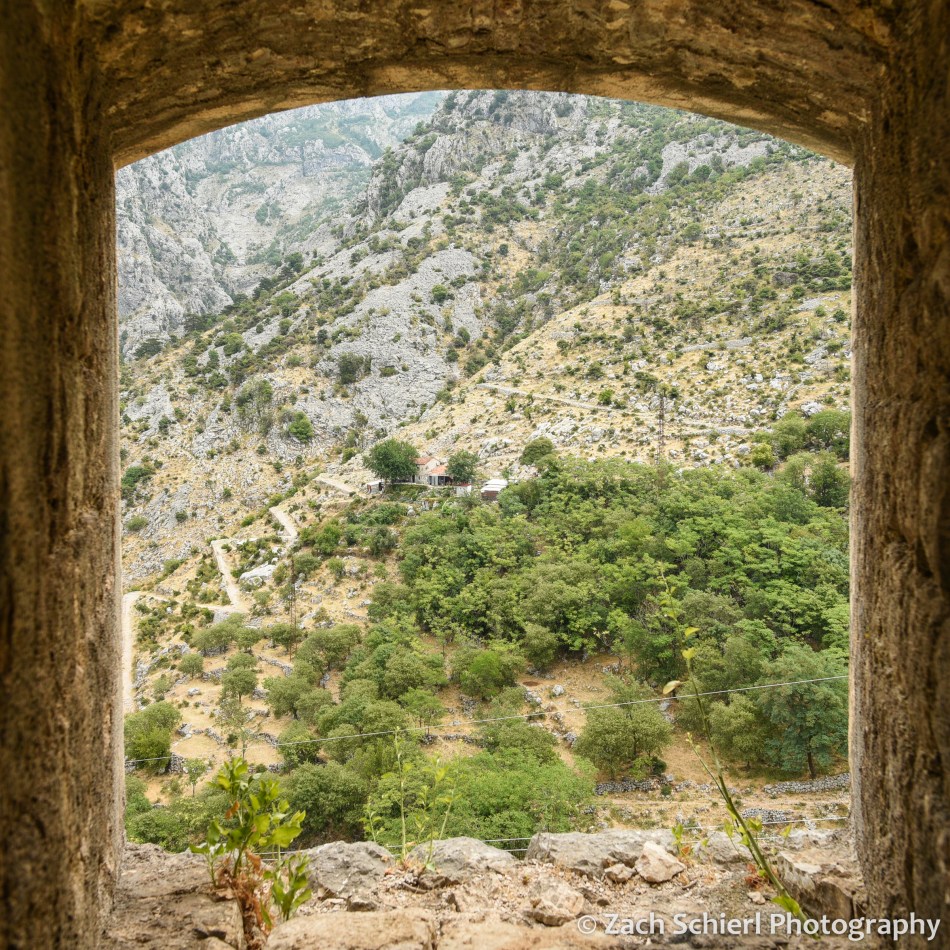
Rather than going back down the way we came, near the summit we exited via a rickety ladder propped up to one of the portals in the wall, and connected with a trail known as the “Ladder of Kotor,” a several thousand year-old route with over 70 switchbacks that leads from the Bay up and over the mountains into the Montenegrin interior. We quickly left the crowds behind and came across the ruins of an old church and village in a little basin tucked into the mountainside. We explored this area a little bit, and walked up the “Ladder” a little ways to look down on the upper portion of the city walls (see photo at top of post). Had we more time, we could have continued another several thousand feet uphill to the very top of the mountains overlooking the Bay of Kotor.
Heading back down, we stopped at a small cafe serving tasty homemade goat cheese, pomegranate juice, and cold beer (here in Part 6, it should go without saying that it was hot and humid) at a handful of tables under a little tin roof, with a beautiful view of the Bay and mountains. The proprietor was hilarious, bustling around and giving us fly swatters to use against the pack of stray cats that were camped out waiting for someone to drop a bit of cheese. We found the cats very entertaining until an orange one made a lunge for our cheese. Fortunately, my cat-like brain and reflexes anticipated the move just in time. Sorry kitties!
From the goat cheese cafe, we continued down the Ladder of Kotor back to town. With almost no other people around, a solid tread (as opposed to crumbling steps), and virtually no trash, we were happy to be headed down this route rather than the walls! Plus, it was cool to follow a historic route that has been in existence for so long and see all the stonework that went into building it over the centuries.
Kotor was another quick stop, and the next day it was already time to head to Albania, the final country on our trip through the western Balkans. Our route took us along the very scenic Montenegrin coastline, however the traffic was horrendous so what should have been a 2-3 hour drive took more like 4-5. Near the southern border of Montenegro, we turned off the coastal highway and started driving inland toward the Albanian border. The border crossing was a breeze…I’m honestly not sure they even looked at our passports!
Not long after crossing the border, we arrived in Shkodër, the fifth largest city in Albania. We didn’t have much time to explore Shkodër unfortunately, as our main goal for the rest of the day was to regroup, repack, and get some supplies for our upcoming journey into the Albanian Alps. We walked around the city center a bit, had a few good meals, and saw the gigantic mosque in the center of town, but that was about it. There didn’t seem to be many tourists around, and those we did see were almost all backpackers headed to the Alps…just like us!

Europe Part 5: Dubrovnik and the Dalmatian Coast


Links to previous posts: Part 1, Part 2, Part 3, Part 4
From Mostar we hopped a bus to Dubrovnik, in theory just a few hours south along Croatia’s Dalmatian Coast. I’m not going to describe that journey in detail here, but it was definitely the most unpleasant travel experience of the trip, and possibly our lives. (Our bout of food poisoning in Italy a few years back, which involved copious vomiting first on a train and then in an elderly Italian woman’s bathroom, didn’t last as long and it wasn’t 100 degrees…)
After crossing the border from Bosnia into Croatia (a crossing that was, thankfully, almost deserted thanks to the opening of the Pelješac Bridge just a few days earlier), the travel gods finally took mercy on us and we arrived in Dubrovnik. We took a taxi to our apartment, and I quickly realized Dubrovnik was another place I was thankful to not be driving. The roads weren’t quite as anarchic as in Sarajevo, but there were a lot of very steep and narrow one way streets, tons of people, and almost non-existent parking. The view from our apartment was gorgeous and expansive due to its location a few hundred feet uphill from the coast. We could see a wide swath of the Adriatic Sea, several islands, and the historic walled old town of Dubrovnik spread out below us. The disadvantage of this location was that getting anywhere involved descending (and later ascending) a series of long, steep staircases in near 100 degree heat + humidity.

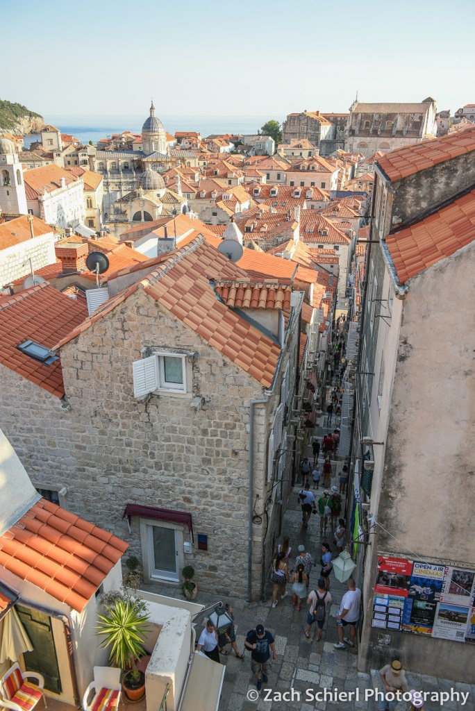
Dubrovnik was pretty much the epitome of what comes to mind when you think of a historic European city: narrow stone streets, lots of churches, lots of tourists, all surrounded by imposing city walls and fortifications. Dubrovnik is extra picturesque in that the whole affair is perched on a rocky peninsula that juts out into the Adriatic Sea. Old town Dubrovnik actually used to be two towns divided by a canal. Eventually the canal was filled in to connect the two towns, forming what is now the wide main boulevard known as the Stradun. (We were told that the loose material used to fill in the canal is likely to collapse in the next major earthquake.) The old town is pedestrian only, and boy were there a lot of pedestrians! Overall though, Dubrovnik was not as busy as we feared. A few years ago, there were often eight or nine cruise ships docked here each day, leading to massive and unsustainable crowds. Through some combination of COVID and limitations imposed by the city, cruise ship traffic has been greatly reduced and there was only one ship docked each of our three days in town. Dubrovnik was the only stop on our entire trip where there seemed to be a lot of other American tourists, roughly 50% of whom seemed to be on a Game of Thrones tour or in a Game of Thrones gift shop at any given moment. (Apparently large portions of GoT were filmed here, though we haven’t seen it so that significance was lost on us…)
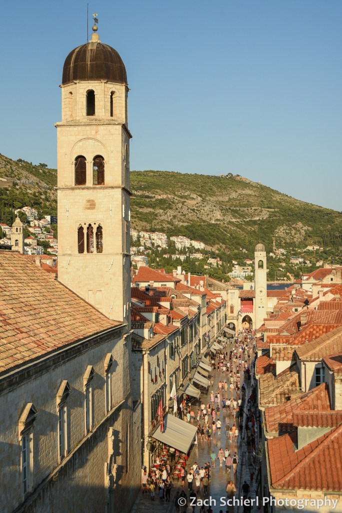
Dubrovnik, long a major trading center along the Adriatic coast, is well-fortified with a ring of tall, thick stone walls completely encircling the old town. A highlight of our visit was a late evening stroll around the top of the walls, with amazing views down into the city on one side, and out into the sea on the other. From above, you can see different colored tile roofs representing buildings of different ages. Most of the city was rebuilt after a big earthquake in 1600, and parts were bombed during Croatia’s war for independence in the 1990s.

As amazing as the city was, it was so hot and humid that we wanted to be in the water the whole time. There were a few small pebbly beaches a short walk from the old town, but these were packed to the point that it was hard to find anywhere to spread out a towel. We found a more relaxing scene by taking a 10-minute ferry ride to an island just offshore: Otok Lokrum. This island is a nature preserve with no permanent population, so there was plenty of room to spread out. There were lots of hiking trails, botanical gardens, some old ruins, a fort, rocky beaches…and cicadas. Lots and lots of very loud cicadas. The cicadas are the ubiquitous soundtrack of the Adriatic coast. Eventually you sort of tune them out, but when you pause to think about them, it is unbelievable how loud they are! We enjoyed swimming and relaxing on a pair of rocky beaches, though we did have to fend off several of the island’s resident peacocks, and avoid the abundant sharp black sea urchins when getting in and out of the water. The following day we kayaked around Otok Lokrum, going into a pair of beautiful sea caves, and getting a seaside view of the imposing Dubrovnik city walls.

After several days in Dubrovnik (and over a week of being in larger cities), we were ready for a change of pace. Just off the coast of Croatia lies an archipelago of long, narrow islands that are collectively the main tourist destination in Croatia. We settled on a trip to Mljet, one of the larger but least populated islands, of which the western third is protected as one of Croatia’s eight national parks. We arrived on Mljet after an uneventful 1.5 hour ride on a high-speed catamaran from Dubrovnik (less exciting than it sounds…actually quite cheap, with airplane-like seating inside. But comfortable and air conditioned!)
The ferry deposited us in the tiny town of Pomena: a few dozen houses, one hotel, a small market, and a handful of restaurants. The main attraction of Mljet National Park is a pair of lakes: one big, one small. These lakes are connected to the sea (and each other) via a pair of narrow channels, so while they look like lakes and are quite calm, they are actually salty. The small lake (Malo Jezero), was only a 10 minute walk from our rented apartment. We purchased some sandwich ingredients from the small market and headed to the lake for a picnic dinner and a sunset swim in the wonderfully warm water.

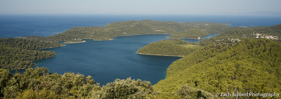
The following day we rented bikes to explore the island. A mostly level and paved bike/pedestrian path encircles the large lake, Veliko Jezero, which makes getting around very enjoyable and peaceful…save for the aforementioned cicadas. Along the way, we stopped to read many of the well-done interpretive signs explaining the natural and cultural history of the park. We ended up biking to the village of Soline, which is on the channel that connects Veliko Jezero to the sea. We enjoyed swimming and snorkeling in the channel, where the water was very shallow and had a mix of vivid blue and green hues. It wasn’t exactly the Virgin Islands from a snorkeling standpoint, but we did see lots of colorful fish, huge sea cucumbers, and various sponges. Thanks to some internet intelligence, we also found the largest coral reef in the Mediterranean. Given that there isn’t much coral at all in the Mediterranean, this also isn’t quite as exciting as it sounds. The coral was a muted brown color, and deep enough that it was hard to get a clear look. More exciting was the fact that I spotted several jellyfish a few seconds after getting into the water, and quickly realized they were ALL over the place. This freaked us out for a moment until we looked them up (because there is cell service everywhere in Europe, even in relatively remote national parks!) and realized that this species was harmless to humans.
On day 2, we got up early to hike up to Montokuc, the highest point in the national park, before it got too hot. Our bikes got us halfway there before we had to actually start walking, so the hike itself was pretty short. The summit is only about 250 meters (a little over 800 feet for the metrically challenged) above sea level, but there is a fire lookout tower at the top with spectacular views. We could see the whole western end of Mljet, the large and small lakes, the channel connecting them to the sea, and several other islands along the Dalmatian Coast. We only saw a few other hikers the whole time…probably the fewest people we had been around since the trip began!
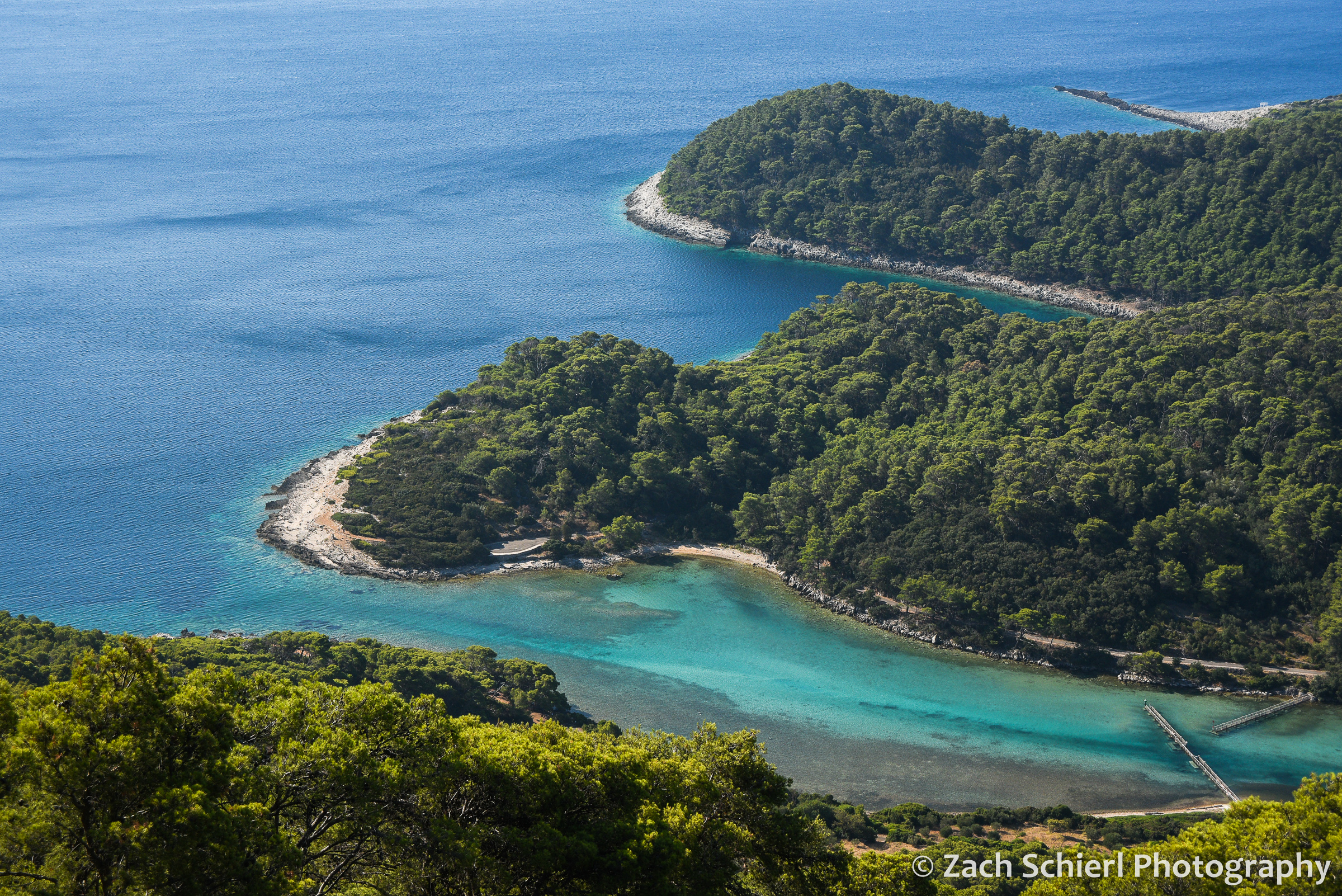
The warm water and air temperature made Mljet feel borderline tropical, though it was clear from the vegetation that it is actually a pretty dry place. Wildfire is a major concern on the island in summer, and there was quite a bit of smoke in the air during our visit, wafting in from fires on other islands and the mainland. Overall, Mljet was a much needed change of pace and probably the most relaxing stop on our month-long trip. While we were far from alone, it was certainly less crowded and more peaceful than most nearby destinations. We would have loved to stay for another day…or week!
From Mljet we hopped back on the ferry to Dubrovnik, and then headed south to Montenegro and Albania!

