Europe Part 5: Dubrovnik and the Dalmatian Coast


Links to previous posts: Part 1, Part 2, Part 3, Part 4
From Mostar we hopped a bus to Dubrovnik, in theory just a few hours south along Croatia’s Dalmatian Coast. I’m not going to describe that journey in detail here, but it was definitely the most unpleasant travel experience of the trip, and possibly our lives. (Our bout of food poisoning in Italy a few years back, which involved copious vomiting first on a train and then in an elderly Italian woman’s bathroom, didn’t last as long and it wasn’t 100 degrees…)
After crossing the border from Bosnia into Croatia (a crossing that was, thankfully, almost deserted thanks to the opening of the Pelješac Bridge just a few days earlier), the travel gods finally took mercy on us and we arrived in Dubrovnik. We took a taxi to our apartment, and I quickly realized Dubrovnik was another place I was thankful to not be driving. The roads weren’t quite as anarchic as in Sarajevo, but there were a lot of very steep and narrow one way streets, tons of people, and almost non-existent parking. The view from our apartment was gorgeous and expansive due to its location a few hundred feet uphill from the coast. We could see a wide swath of the Adriatic Sea, several islands, and the historic walled old town of Dubrovnik spread out below us. The disadvantage of this location was that getting anywhere involved descending (and later ascending) a series of long, steep staircases in near 100 degree heat + humidity.

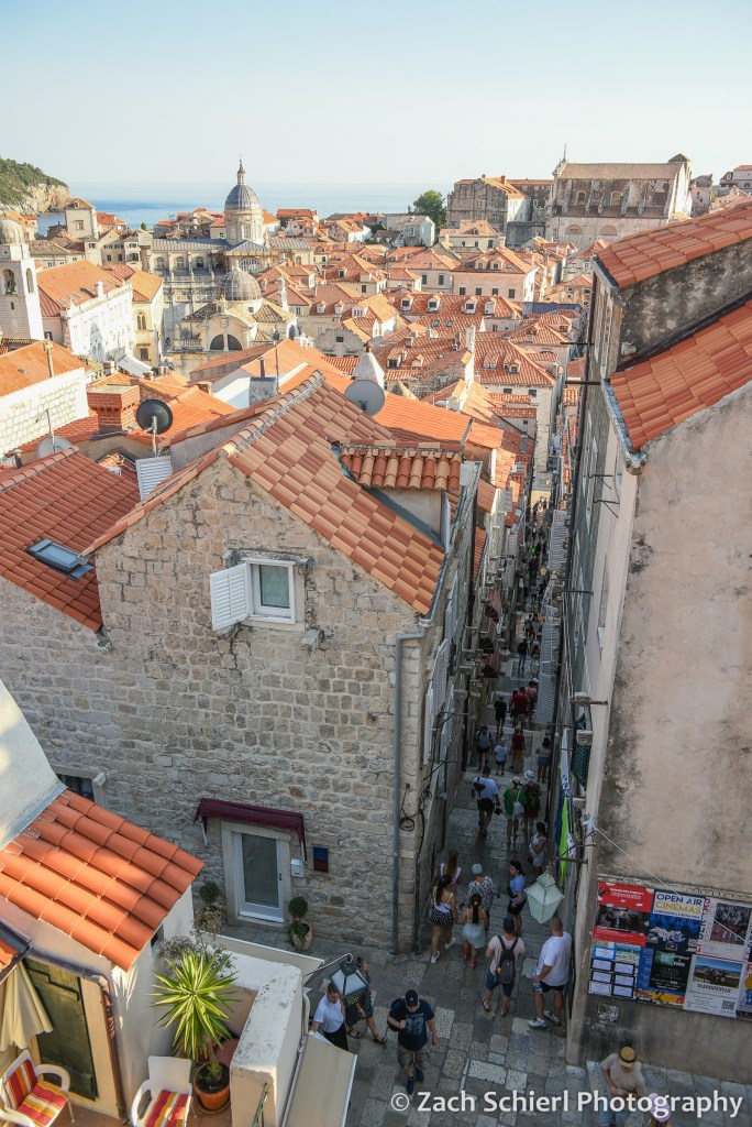
Dubrovnik was pretty much the epitome of what comes to mind when you think of a historic European city: narrow stone streets, lots of churches, lots of tourists, all surrounded by imposing city walls and fortifications. Dubrovnik is extra picturesque in that the whole affair is perched on a rocky peninsula that juts out into the Adriatic Sea. Old town Dubrovnik actually used to be two towns divided by a canal. Eventually the canal was filled in to connect the two towns, forming what is now the wide main boulevard known as the Stradun. (We were told that the loose material used to fill in the canal is likely to collapse in the next major earthquake.) The old town is pedestrian only, and boy were there a lot of pedestrians! Overall though, Dubrovnik was not as busy as we feared. A few years ago, there were often eight or nine cruise ships docked here each day, leading to massive and unsustainable crowds. Through some combination of COVID and limitations imposed by the city, cruise ship traffic has been greatly reduced and there was only one ship docked each of our three days in town. Dubrovnik was the only stop on our entire trip where there seemed to be a lot of other American tourists, roughly 50% of whom seemed to be on a Game of Thrones tour or in a Game of Thrones gift shop at any given moment. (Apparently large portions of GoT were filmed here, though we haven’t seen it so that significance was lost on us…)
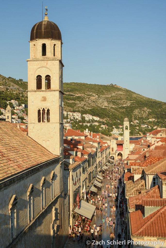
Dubrovnik, long a major trading center along the Adriatic coast, is well-fortified with a ring of tall, thick stone walls completely encircling the old town. A highlight of our visit was a late evening stroll around the top of the walls, with amazing views down into the city on one side, and out into the sea on the other. From above, you can see different colored tile roofs representing buildings of different ages. Most of the city was rebuilt after a big earthquake in 1600, and parts were bombed during Croatia’s war for independence in the 1990s.

As amazing as the city was, it was so hot and humid that we wanted to be in the water the whole time. There were a few small pebbly beaches a short walk from the old town, but these were packed to the point that it was hard to find anywhere to spread out a towel. We found a more relaxing scene by taking a 10-minute ferry ride to an island just offshore: Otok Lokrum. This island is a nature preserve with no permanent population, so there was plenty of room to spread out. There were lots of hiking trails, botanical gardens, some old ruins, a fort, rocky beaches…and cicadas. Lots and lots of very loud cicadas. The cicadas are the ubiquitous soundtrack of the Adriatic coast. Eventually you sort of tune them out, but when you pause to think about them, it is unbelievable how loud they are! We enjoyed swimming and relaxing on a pair of rocky beaches, though we did have to fend off several of the island’s resident peacocks, and avoid the abundant sharp black sea urchins when getting in and out of the water. The following day we kayaked around Otok Lokrum, going into a pair of beautiful sea caves, and getting a seaside view of the imposing Dubrovnik city walls.

After several days in Dubrovnik (and over a week of being in larger cities), we were ready for a change of pace. Just off the coast of Croatia lies an archipelago of long, narrow islands that are collectively the main tourist destination in Croatia. We settled on a trip to Mljet, one of the larger but least populated islands, of which the western third is protected as one of Croatia’s eight national parks. We arrived on Mljet after an uneventful 1.5 hour ride on a high-speed catamaran from Dubrovnik (less exciting than it sounds…actually quite cheap, with airplane-like seating inside. But comfortable and air conditioned!)
The ferry deposited us in the tiny town of Pomena: a few dozen houses, one hotel, a small market, and a handful of restaurants. The main attraction of Mljet National Park is a pair of lakes: one big, one small. These lakes are connected to the sea (and each other) via a pair of narrow channels, so while they look like lakes and are quite calm, they are actually salty. The small lake (Malo Jezero), was only a 10 minute walk from our rented apartment. We purchased some sandwich ingredients from the small market and headed to the lake for a picnic dinner and a sunset swim in the wonderfully warm water.

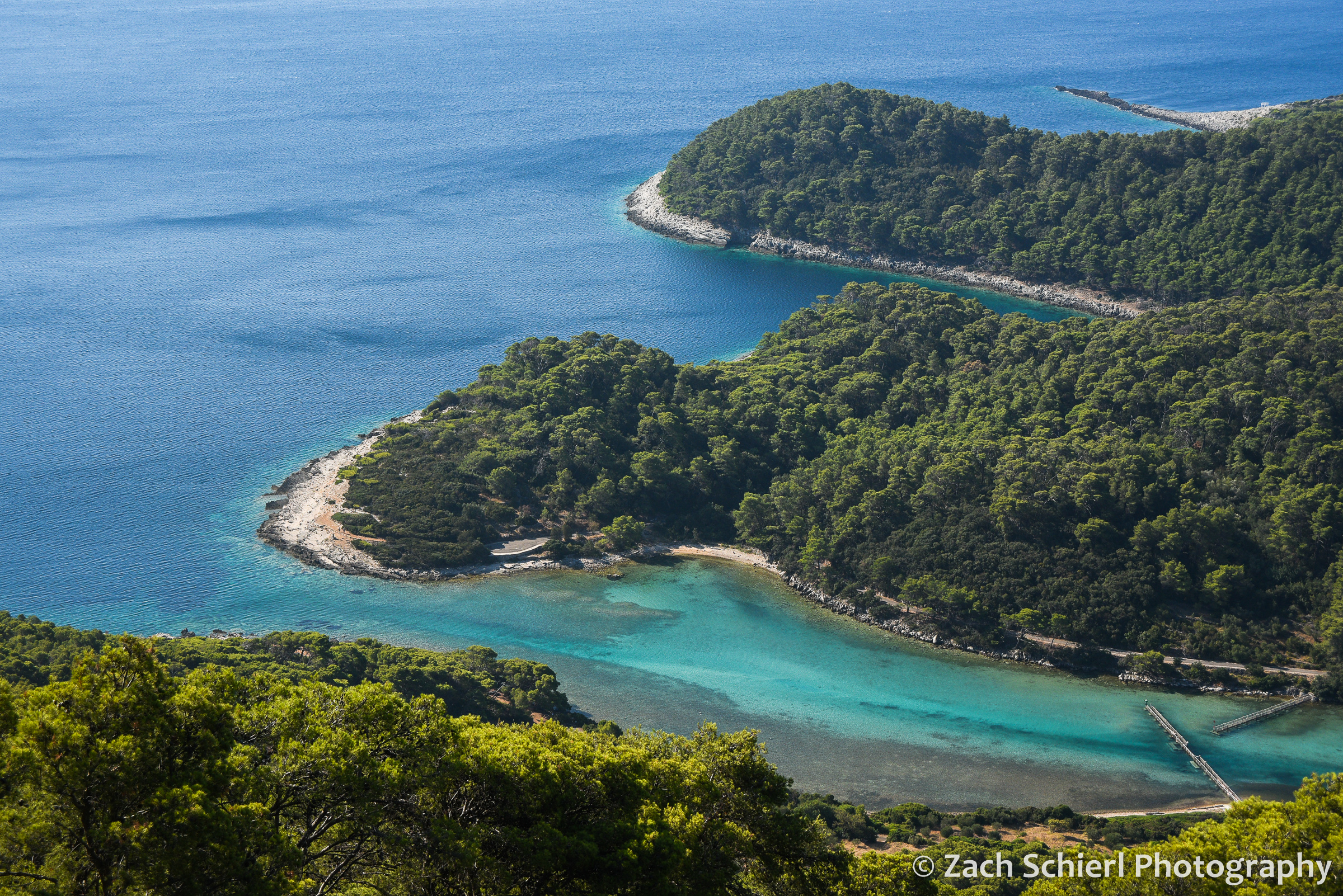
The following day we rented bikes to explore the island. A mostly level and paved bike/pedestrian path encircles the large lake, Veliko Jezero, which makes getting around very enjoyable and peaceful…save for the aforementioned cicadas. Along the way, we stopped to read many of the well-done interpretive signs explaining the natural and cultural history of the park. We ended up biking to the village of Soline, which is on the channel that connects Veliko Jezero to the sea. We enjoyed swimming and snorkeling in the channel, where the water was very shallow and had a mix of vivid blue and green hues. It wasn’t exactly the Virgin Islands from a snorkeling standpoint, but we did see lots of colorful fish, huge sea cucumbers, and various sponges. Thanks to some internet intelligence, we also found the largest coral reef in the Mediterranean. Given that there isn’t much coral at all in the Mediterranean, this also isn’t quite as exciting as it sounds. The coral was a muted brown color, and deep enough that it was hard to get a clear look. More exciting was the fact that I spotted several jellyfish a few seconds after getting into the water, and quickly realized they were ALL over the place. This freaked us out for a moment until we looked them up (because there is cell service everywhere in Europe, even in relatively remote national parks!) and realized that this species was harmless to humans.
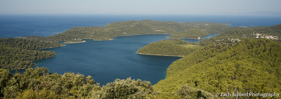
On day 2, we got up early to hike up to Montokuc, the highest point in the national park, before it got too hot. Our bikes got us halfway there before we had to actually start walking, so the hike itself was pretty short. The summit is only about 250 meters (a little over 800 feet for the metrically challenged) above sea level, but there is a fire lookout tower at the top with spectacular views. We could see the whole western end of Mljet, the large and small lakes, the channel connecting them to the sea, and several other islands along the Dalmatian Coast. We only saw a few other hikers the whole time…probably the fewest people we had been around since the trip began!
The warm water and air temperature made Mljet feel borderline tropical, though it was clear from the vegetation that it is actually a pretty dry place. Wildfire is a major concern on the island in summer, and there was quite a bit of smoke in the air during our visit, wafting in from fires on other islands and the mainland. Overall, Mljet was a much needed change of pace and probably the most relaxing stop on our month-long trip. While we were far from alone, it was certainly less crowded and more peaceful than most nearby destinations. We would have loved to stay for another day…or week!
From Mljet we hopped back on the ferry to Dubrovnik, and then headed south to Montenegro and Albania!

Europe Part 4: Sarajevo and Mostar

Links to previous posts: Part 1, Part 2, Part 3
A short 45 minute flight on Croatia Airlines took us to Sarajevo, the capital and largest city of Bosnia and Herzegovina. We arrived around midnight and hailed a taxi from the airport to our lodging in the city center. I was immediately glad to not be piloting a rental car here! Even as the clock approached midnight, the taxi ride was…shall we say…exciting; hilly terrain, pedestrians at every turn, lots of traffic sharing the road with rumbling communist-era trams, and sidewalks seemingly used as an extension of roads and parking lots.
Chaotic start aside, Sarajevo ended up being one of our favorite stops on the entire trip. There is so much complex and fascinating history packed into this relatively small city. Sarajevo has been a meeting point of cultures and a model of religious tolerance for hundreds of years. Ironically and sadly, the city is perhaps best known for two darker moments: the assassination that sparked World War I, and a tragic four-year siege in the early 1990s during Bosnia’s war for independence from Yugoslavia.

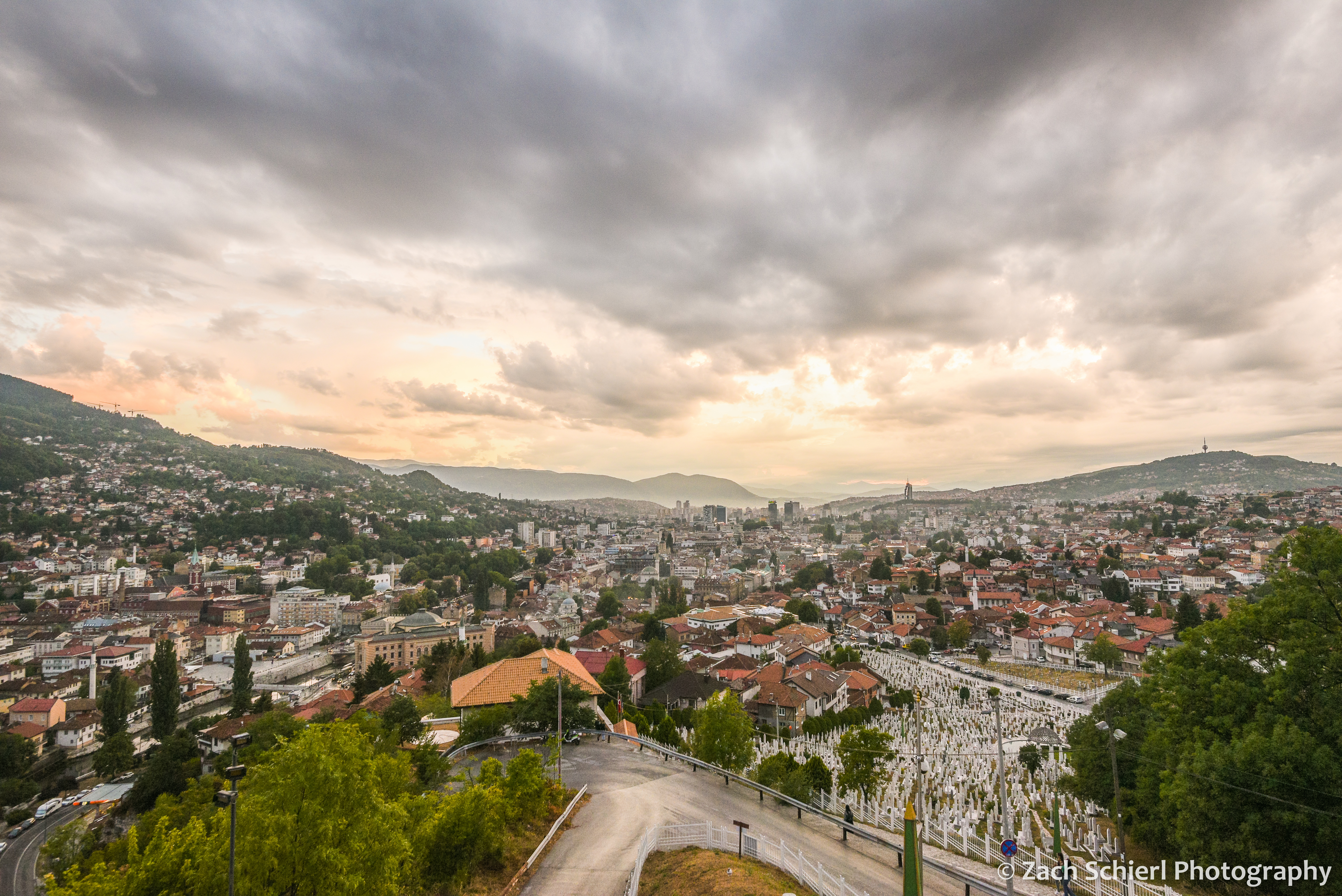
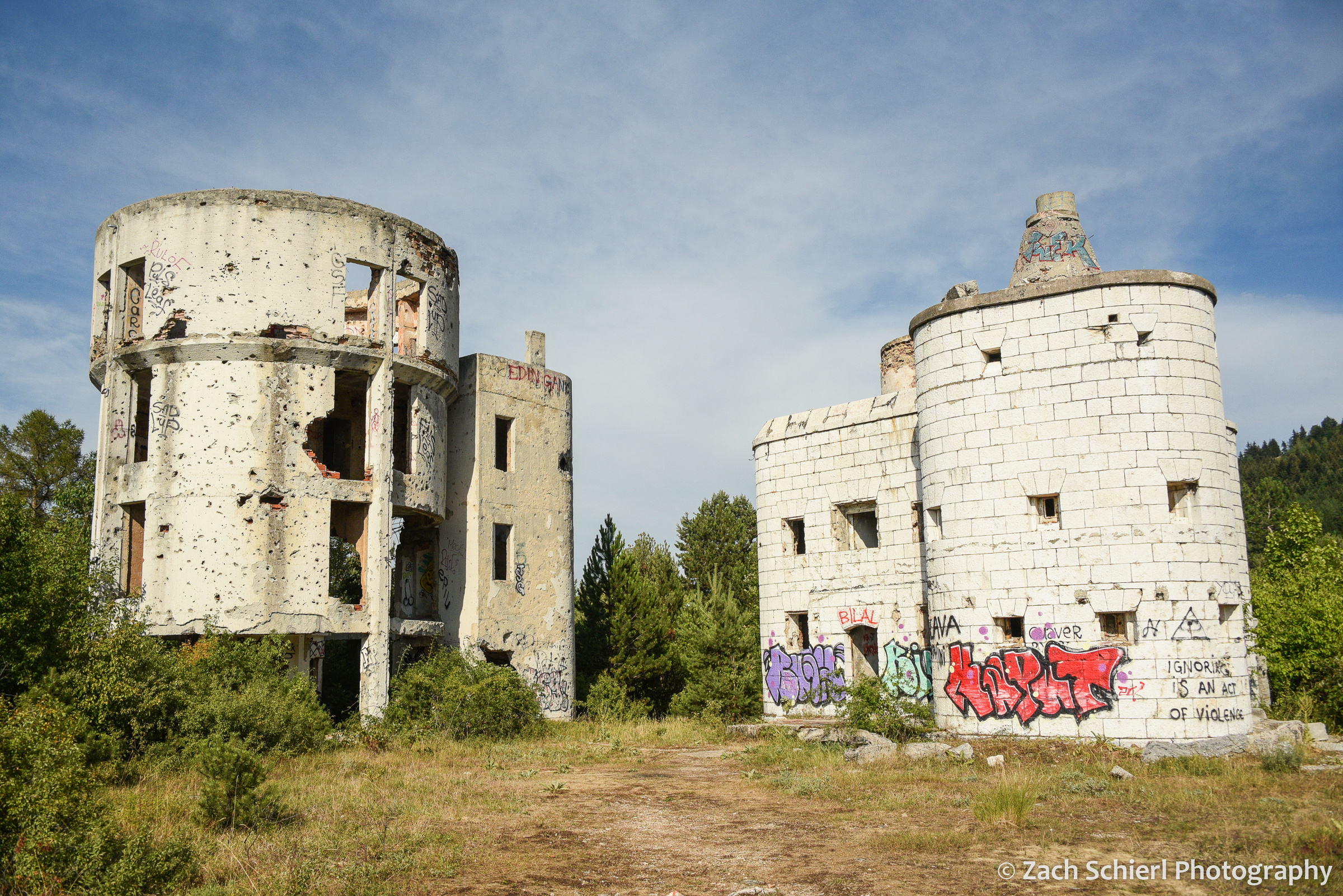
More on the history later, but the first thing that struck us when we looked out the window the following morning was that Sarajevo is situated in an absolutely gorgeous landscape. It’s one of the few cities I can recall that seems to complement the natural landscape rather than detract from it. The bulk of the city is confined to a long, narrow valley that slices through the Dinaric Alps, with the Miljacka River winding along its bottom. Mt. Trebević rises more than a thousand feet above the city to the south, while other hills bound the valley immediately to the north and east. While this makes for gorgeous scenery, the unique geography was what allowed the Bosnian Serb Army to besiege and terrorize residents of Sarajevo from 1992 to 1996. One prominent casualty of the siege is the bobsled track used in the 1984 Winter Olympics, located on the slopes of Trebević above town. The track was used as fortification during the war and is now abandoned, as are the shelled out remains of the Čolina Kapa Astronomical Observatory (the only professional observatory in Bosnia) nearby. We took the recently (2018) rebuilt cable car to the top of Trebević to get a bird’s eye view of Sarajevo and then enjoyed a pleasant, though at times eerie, hike back down into town, past the crumbling, graffiti covered bobsled track and through several residential neighborhoods perched above the main city.

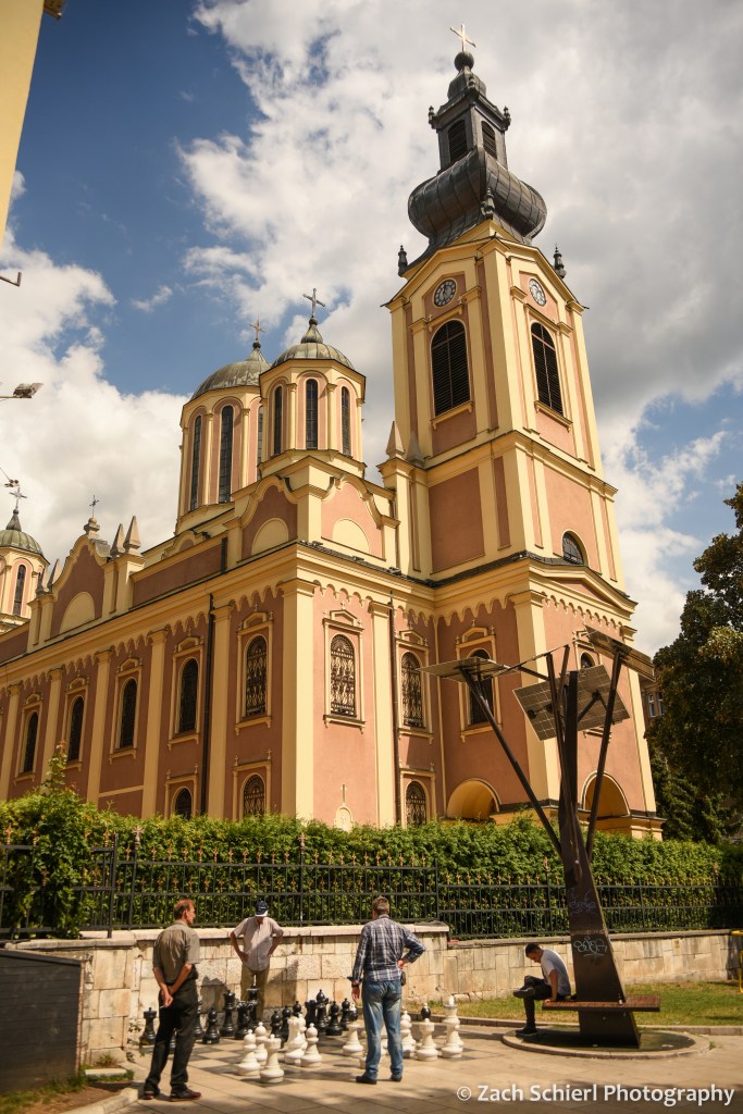
Today, Sarajevo (and Bosnia itself) is majority Muslim. Half a dozen mosques, with their pointy minarets, are visible from just about any point in town, and the city is punctuated with the sounds of the Adhan (Muslim call to prayer) issuing from the minaret loudspeakers five times a day. Interspersed among the mosques are several Catholic cathedral spires, eastern Orthodox churches, and a Jewish synagogue, indicative of how people of many faiths have converged and lived together peacefully in Sarajevo throughout most of its history.
At the east end of Sarajevo is the Baščaršija, the “old town” with architecture dating from the era when Bosnia was part of the Ottoman Empire. The tiled roofs, narrow lanes, and bazaars seem transported here from Turkey or the Middle East.


West of the Baščaršija is a newer section of town with buildings resembling those in Ljubljana, built during the late 1800s when Bosnia was part of Austria-Hungary. Speaking of Austria-Hungary, the heir to that throne, Archduke Franz Ferdinand, was on an official visit to Sarajevo in 1914 when he was assassinated by a Serbian separatist on a non-descript street corner along the Miljacka River. Austria-Hungary demanded that Serbia investigate the assassination, and when they refused, Austria-Hungary declared war on Serbia, triggering alliances that plunged the globe into World War I. The site today is home to a small museum and marked by a a plaque and metal plates showing where Ferdinand’s convertible was stopped during the shooting.
Even further west is the modern business and government district, with its large hotels, skyscrapers, shopping malls, and lots of traffic. It is also home to the U.S. Embassy, which appeared to be better fortified than the Bosnian parliament building across the street. We explored this area a bit on our final morning in Sarajevo, on our way to the nearby train station. After a short ride on one one of the extremely rickety but charismatic communist-era trams, we took the elevator up to the 35th floor of the Avaz Twist Tower skyscraper for an aerial view of the city.

We ended up spending almost an entire day with a local guide, journalist, and siege veteran, Amir Telibećirović, who wove a powerful narrative of Bosnian history, from ancient times up through the present day, while walking with us around town to visit a variety of sights. Especially striking were the many small cemeteries containing hundreds of white headstones from the siege. These cemeteries were located right in the middle of town, in strategic locations where the risk of sniper fire was minimized. Even then, residents typically waited to conduct burials during periods of heavy fog. While Sarajevo is a bustling city filled with tourists today, the scars of war are still quite obvious here, more so than anywhere else on our journey through the former Yugoslavia. Many buildings remain riddled with holes from shrapnel and bullets, especially if you stray away from the main tourist destinations. And beyond building facades, Bosnia’s economy has been slow to recover and unemployment remains quite high compared to other Balkan countries.
In addition to soaking up the local history, we also spent a fair amount of time soaking up calories by trying the many delicious local foods, including strong Bosnian coffee, burek (filo dough rolls stuffed with meat, cheeses, potatoes, etc) and Ćevapi (little sausages in pita-like bread with a creamy cheese called kajmak). All very tasty, and all very meaty. We frequently remarked on how it would be hard to be a vegetarian in Bosnia! Another highlight was sunset from atop an old fortification called the Yellow Fortress. From here we had a spectacular view looking west down the Miljacka River valley toward the setting sun. With residual clouds from a series of brief thunderstorms earlier in the day, the lighting was truly spectacular, and combined with the illuminated mosques and call to prayer, it made for a very unique and memorable experience.

After several days in Sarajevo, we boarded a train and headed south to Mostar. We were once again reminded of the ease and comfort of European train travel. (It’s a damn shame this mode of transportation isn’t more viable in the U.S.) As we rolled through the scenic mountains of Bosnia, the vegetation changed gradually, from the relatively verdant landscape near Sarajevo to a more desert-like, Mediterranean landscape as we neared Mostar.
From the train station in Mostar, it was a twenty minute walk to our hotel for the evening. It was getting close to sunset so we made a quick detour to see the primary attraction of Mostar: Stari Most (the “Old Bridge”). The Old Bridge is, not surprisingly, a bridge spanning the Neretva River, connecting the east and west halves of Mostar. It is not, however, very old. The bridge was originally built in the 1500s but was sadly destroyed during the Bosnian war in the early 1990s, along with much of Mostar. Today’s bridge was rebuilt in the early 2000s, using the same techniques, tools, and materials used in the original version. Shops and restaurants line the cliffs along the river on either side of the bridge, and it was PACKED! We had a somewhat forgettable dinner in an unforgettable setting on the banks of the river with a beautiful view of the bridge and city.

Mostar was a brief stop en route to the Adriatic coast, so we unfortunately didn’t have much time to explore beyond the main sights. After less than 24 hours, we were walking back to the train station to catch a bus to Dubrovnik, an experience that turned out to be the polar opposite of our train journeys in just about every way possible. That’s next time!

Europe Part 3: A Cavalcade of Capitals

After starting off our trip with a foray through the mountains, the next leg was decidedly more urban as we toured a trio of capital cities: Ljubljana, Zagreb, and Sarajevo.
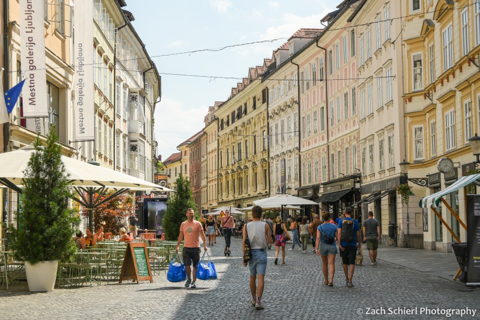
After returning our rental car at the Ljubljana Airport, we took a shuttle into the city center. Ljubljana, the capital of Slovenia, is relatively small for a European capital, with just a few hundred thousand residents. The city was heavily damaged during a large earthquake in 1895. At the time, Slovenia was part of the Austro-Hungarian Empire, so many of the buildings in the city center were rebuilt in the same architectural style prominent in cities like Prague and Vienna. For the last decade or so, the center of Ljubljana has been set aside as a pedestrian zone…no cars allowed! We enjoyed our limited time in town strolling the wonderfully car-free streets, crisscrossing the many bridges over the Ljubljanica River, and riding the funicular up to the castle that overlooks the old town. The highlight was a food and wine tour with a local guide and wine expert who introduced us to a variety of foods and wines from different regions of Slovenia: deep fried sardines from the Adriatic coast, homemade meats and cheeses from the Hungarian-influenced northeast, Carniolan sausages and barley stew from the southwest, and a delicious layered dessert with dumpling, nuts, raisin, breadcrumbs, and creamy cheese.

We also learned more about life in Slovenia and the recent history of the area from our guide. Most of the countries on our trip were part of the former communist republic of Yugoslavia. Slovenia was the first to declare independence in 1991 and fortunately did not experience the brutal conflicts that followed independence declarations in neighboring Croatia and Bosnia. Talking to our guide, we learned that Slovenia’s education system is well-funded, pre-K childcare costs only a little over $100/month, college and housing are relatively affordable, and new mothers are guaranteed a year of paid maternity leave. As a country, Slovenia also seems to be more environmentally conscious that most. After a week in Slovenia, we left with the impression that this is a progressive country that cares about making life better for its residents. What a concept!

Ljubljana was one of many stops where we wished we could stay longer, but after about 24 hours, we were on one of the few train journeys of our trip to Zagreb, the capital and largest city of Croatia. Zagreb is much larger than Ljubljana, with roughly one million inhabitants, and the difference was noticeable from the moment we stepped off the train. The overall atmosphere of Zagreb felt like a much larger, faster paced urban center compared to the relative tranquility of Ljubljana.
Most of Zagreb is relatively young by European standards, with much of the city center built up over just the past 150 years. (Quite a few buildings, including all of the major cathedrals, were in scaffolding during our visit, still under repair from damage incurred during a major earthquake in March 2020.) Our room for the night was in the small “old town” section of Zagreb, which consists of two adjacent hills with buildings dating back to the 1500s. At odds with one another for most of history, these two towns officially merged in the 1850s, leading to the creation of the greater Zagreb that exists today.
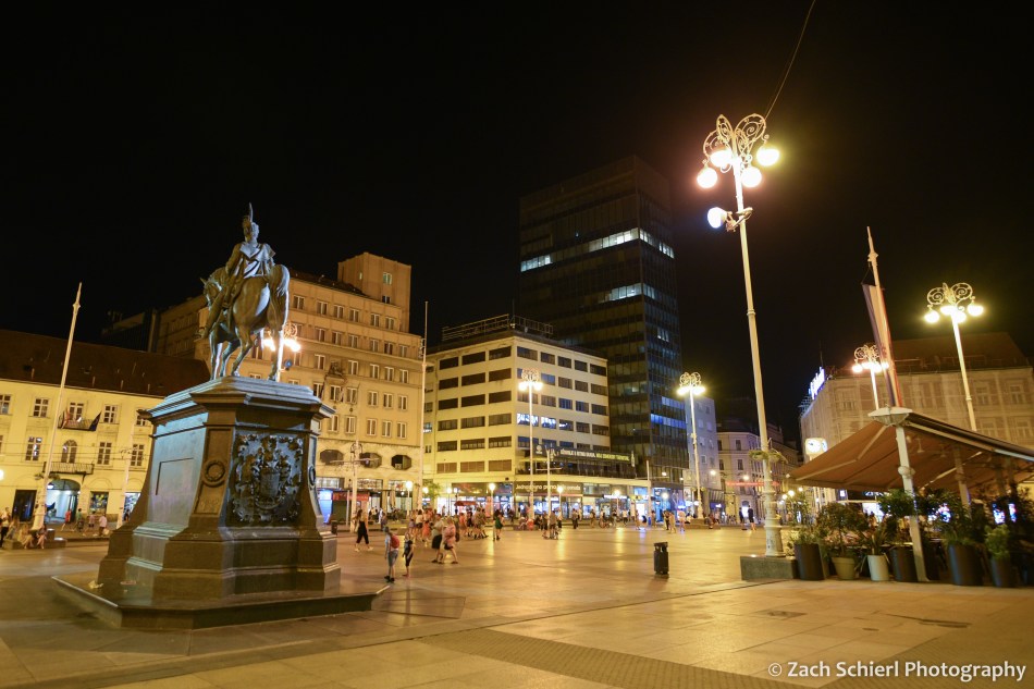
Like all of the cities we visited on this trip, Zagreb was bumping. We never ceased to be amazed by how many people (tourists and locals alike) were out and about late into the evening, regardless of whether it was a Tuesday, Thursday, or Saturday. Sitting on Jelačić Square (the central social and transportation hub of Zagreb, pictured above) late at night, watching a steady stream of electric trams whisk people back to all parts of the city, definitely made us reflect on how the U.S. cities we’ve lived in are built so differently.
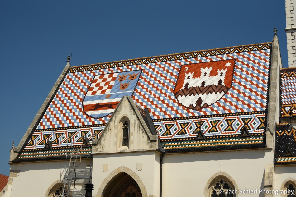
Our time in Zagreb was also limited, so the following morning we took a free walking tour to get our bearings. At the top of the town was St. Marks Church, with its unique roof covered in colorful tiles depicting the coat of arms of Croatia (left) and the city of Zagreb (right):
In the afternoon, we took another walking tour focusing on the war for Croatia’s independence in the early 1990s. The events that led to this war (and the others in the Balkans around the same time) are, of course, incredibly complex and require a good understanding of history going all the way back to at least World War I to truly understand. While summarizing this history is not really within the scope or intent of this photography blog, I will say that it was absolutely fascinating to hear the varying perspectives on these conflicts via museums, tours, and conversations in several different countries. On our tour in Zagreb, we walked through some of the underground tunnels and bunkers that were originally built during WWII and then used again as bomb shelters during the recent war. Today, many of these tunnels remain in use as “shortcuts” for residents to get from one part of the city to another. (As an added bonus, it was a solid 30 degrees cooler down there than on the surface!)
Ultimately, I didn’t take a ton of photos in Zagreb or Ljubljana. Both cities were at their best after nightfall, and I definitely could have used a tripod. Many of the night scenes I photographed turned out rather blurry. From Zagreb we caught a short, late evening flight to Sarajevo which ended up being one of the highlights of our trip and will get its own post next time!
