Where the Rivers Run Orange: Remnants of a Colorado Silver Rush
The San Juan Mountains have a way of making you feel uneasy. Perhaps this has something to do with the fact that the most infamous cannibal of our time, one Alferd Packer, consumed five of his fellow prospectors here during the winter of 1873-1874. But while the alpine scenery rivals or exceeds that of any mountain range I’ve ever visited, the fact that many of the streams cascading down the steep slopes run with a neon, metallic orange color that coats every last pebble along the streambed in a golden veneer lets you know that something is wrong.

A very orange and acidic Red Mountain Creek
While you might think that someone dumped a truckload of kool-aid into the mountains, in reality it’s because the San Juan’s used to be gold and silver country. Looking at a topographic map of the San Juan’s is like looking at some sort of twisted and tortuous treasure map, with literally thousands upon thousands of tiny crosses marking the locations of long defunct mine shafts, many of them waiting to swallow up the unaware hiker. The majority of these mines were established in the later 1800’s when silver in previously unheard of concentrations was discovered in the mountains, along with smaller amounts of gold, zinc, copper, and other heavy metals. Like an enormous hardrock gopher mound, the San Juan’s are riddled with underground mining tunnels. It is possible to travel between the towns of Silverton and Telluride, several hours apart by road, without ever setting foot on the surface of the Earth. While few active mines still exist, the imprint that the mining had on the land is readily apparent to anyone traveling between Ouray and Silverton on U.S. Highway 550, commonly known as the Million Dollar Highway (for reasons which are disputed…) which, due to the persistent lack of guardrails along its more perilous stretches, is not for the faint of heart.

Ouray, Colorado: founded as a mining town in 1876 and the self-proclaimed “Switzerland of America”
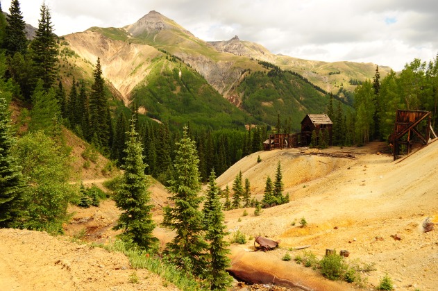
Remnant buildings and tailings of the Guston Mine
Ouray County Road 31 branches off of Hwy 550 about halfway between Ouray and Silverton and winds through the Red Mountain Mining District for several miles. This area, located about 10,000 feet above sea level, was home to a number of rowdy mining towns during the its heyday in the 1800’s. Since I am rarely (ok, never) mistaken for a history buff, an excellent history of the Red Mountain District written by people who know what they are talking about more than I do can be found here. The road is marked as a 4WD on maps road but seemed very well maintained. I ventured that I could have gotten my trusty Toyota Corolla down it when dry, but probably not at a rate much faster than I could walk it. As a result, I parked my car along the highway and struck out on foot. In hindsight this was both a good and a bad idea. Bad in that the skies of Colorado decided to unleash their first drops of moisture in months, when naturally I had left my rainjacket at home. Thankfully, old mine buildings make for decent shelter if you can find one that doesn’t look like it will collapse in the slightest gust of wind. However this was good considering that the road basically turned into a clay bog as soon as it started raining which means that I would have been S.O.L had I decided to drive instead of walk.

The mainframe of the Yankee Girl Mine, one of the most productive and lucrative silver mines in the San Juan’s
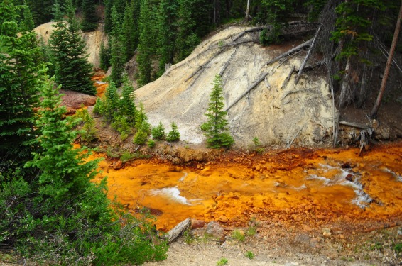
Acid mine drainage along a creek near Red Mountain
A short walk in along Road 31 and it becomes immediately apparent that the land has been completely and utterly gutted by the silver mining process. It is the bright orange creeks and streams catch your eye first. This phenomenon is known as acid mine drainage, and occurs when rainwater or snowmelt comes into contact with metal-rich rocks, such as the rock that composes the tailings piles that surround all of the old mines. The water leaches metals, most commonly iron, out of the rock and into to the water. The iron then oxidizes resulting in the highly acidic, bright orange water that flows throughout the region. Perhaps even more pervasive than the orange creeks though is the smell. Nearly all of the mines and tailings piles are accompanied by a metallic, musty odor that leaves you with the funny feeling that it would probably be a bad life decision to inhale the air for an extended period of time. The smell is truly difficult to describe, the closest analogy I can think of is the hydrogen sulfide so commonly associated with the geysers and hot springs of Yellowstone, although this still falls short. This smell was much less sulfurous and disagreeable, and while I wouldn’t go as far as to say it was pleasant, it wasn’t bad enough to make me cover my airways with a bandanna or seek refuge somewhere else.

The National Belle Mine overlooks the former site of Red Mountain Town

One of the last remaining structures in Red Mountain Town
Stop number two for the day was the remains of another 19th century mining camp: Ironton. Unlike the Red Mountain District, which was so extensively mined that it is essentially located on a barren hillside that has been mostly stripped of trees, Ironton and its associated mines, such as the Colorado Boy seen below, are nestled deeper within the forest. A well marked trail leads to Colorado Boy but many of the other sites in the area are located along routes that have been nearly completely reclaimed by the forest, making them difficult to find without a good map and good sense of direction since GPS devices don’t work worth a darn in the dense woods.
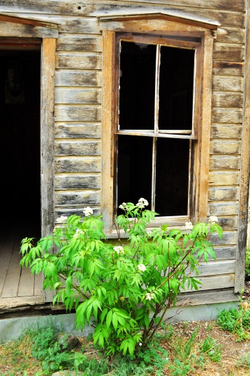
One of about a dozen structures still standing in Ironton
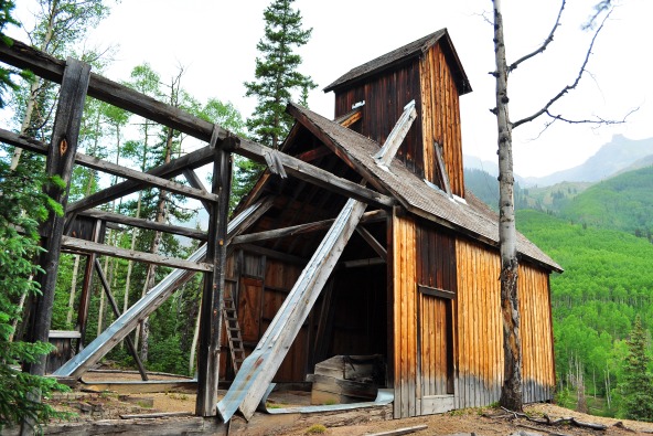
Mainframe of the Colorado Boy Mine
Just south of Ironton, spanning a large gully known as Corkscrew Gulch, lies a bridge that I am convinced was the inspiration for the rickety wooden span in Shrek that Donkey and Shrek traverse in order to cross the boiling lake of lava. Oddly, this interesting relic isn’t listed on any maps of the area and I was unable to find many pictures of it online, yet it was one of the highlights of the day. I initially spotted the bridge from below, it wasn’t even obvious that it was a bridge at first but being the curious cat that I am, I was naturally intrigued. After about a half hour of bushwhacking my way up the ridge on the west side of the gulch, I located the trace of an old, overgrown wagon road that eventually led me to the edge of the canyon and the bridge abutments. Now this bridge, missing as many planks as it was, would have been completely impassable regardless but for whatever reason, one of the two cables spanning the gulch had been cut causing the span of the bridge to hang like a limp wet noodle across the canyon. The bridge is in such bad shape that the weight of a house fly alighting on the remaining cable would likely cause the remainder of the structure to plummet several hundred feet to the streambed below. Interestingly, upon further research, this bridge was at one point the longest suspension bridge in Colorado. To this day, it holds the unofficial title of “sketchiest bridge in Colorado” and I don’t envision it relinquishing this title any time soon.
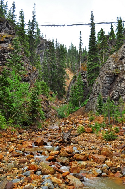
Sketchy bridge from the bottom of Corkscrew Gulch

View of the bridge from slightly uphill
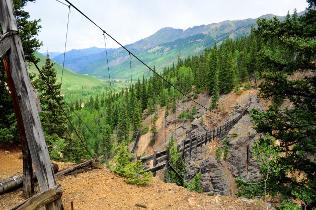
A closer and more detailed view of the sketchiness
Despite the glaring environmental ramifications and water quality issues associated with the mining that took place here, , spending an afternoon exploring the mines was a fascinating step back into the exciting history of the San Juan Mountains and southwestern Colorado. The mines are so prevalent and such a seemingly integral part of the landscape here that it is sort of difficult to imagine the San Juan’s without them. Just don’t drink the water….

I loved your post! You’re right, I think I would have liked exploring this area with you, it’s very beautiful although the orange water is definitely a little eerie. See you in a few weeks 🙂
June 29, 2012 at 9:59 pm
Pingback: Boulders to Bullion: A Tour Through the Mayflower Gold Mill | Pyroclastic Pixels